Robla Community Plan
During the update of the 2040 General Plan, City staff received concerns from the community about the Robla neighborhood. It was evident that more work was needed to better understand the issues and determine what could be done to address them. A land use and placemaking policy was included in the North Sacramento Community Plan that states:
NS-LUP-3, Engage North of I-80, the City shall engage the neighborhoods north of I-80 in an effort to assess community needs and identify the appropriate level of planning study required for the area.
Over the next few years, City staff will be working with Robla residents, businesses, and other community partners to understand the issues, create a shared vision for Robla, and determine which issues may be addressed through the next general plan update.
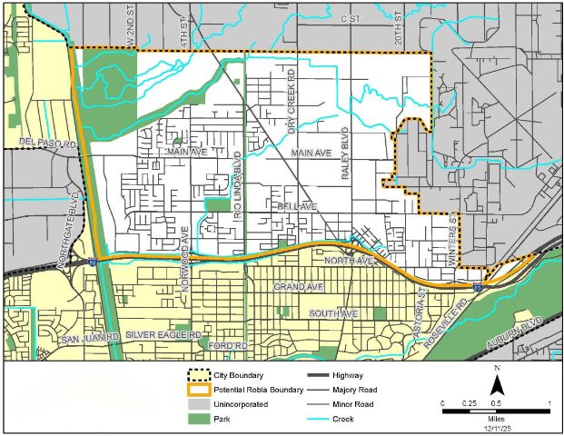
Robla Area
If you would like to be kept up-to-date of upcoming events or see when new documents are posted, please sign up for our mailing list.
Get in touch with the Robla Team
Sign up for the email list to get updates
Meetings and events
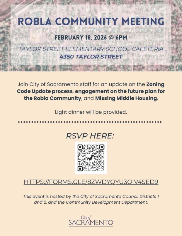
Robla Community Meeting – February 18, 2026
Council Districts 1 and 2, and City of Sacramento staff held a community meeting to provide an update on the Zoning Code Update process, engagement on the future plan for the Robla Community, and Missing Middle Housing.
Date: February 18, 2026
Time: 6:00 PM
Location: Taylor Street Elementary School Cafeteria
Address: 4350 Taylor St
Staff provided a brief presentation and then hosted three topical stations. Photos of the boards and comments received are available here.
Council Districts 1 and 2 hosted a community meeting to provide Robla residents updates and receive comments.
Robla Park Community Association Action Committee Meeting – November 5, 2025
At a regularly scheduled hybrid meeting, the Robla Park Community Association Action Committee invited City staff to discuss issues in Robla and to follow-up on the September 30, 2025, community listening session. There were approximately 15 people attending in person. Staff listened and compiled the notes based on what was shared by the community during the conversation which can be read here.
Date: November 05, 2025
Time: 6:30-7:30 PM
Location: Roundtable Pizza
Listening Session – September 30, 2025
The offices of councilmembers Dickinson (District 2) and Kaplan (District 1) conducted a listening session:
Date: September 30, 2025
Time: 6:00-7:30 PM
Location: Taylor Street Elementary School
During this meeting, City staff provided an overview of local land use planning processes and asked for community input on key questions to better understand the issues. Approximately 25 people attended. Staff distributed a handout to attendees and asked them to respond to the following questions:
- What do you like about Robla?
- What concerns/issues would you like us to know about?
- Who should City staff interview/engage with?
- Are there upcoming events where staff can meet with residents/businesses?
Meeting attendees submitted responses to these questions at the meeting and some input was emailed to staff after the meeting. Staff compiled the responses, the meeting summary can be read here.