Sacramento River Parkway Project
Welcome to the Sacramento River Parkway Project webpage. This page provides current information about the Sacramento River Parkway Project's progress and the historical work to date.
- Frequently asked questions (FAQs)
- Virtual Community Meetings
- Public Open House Meetings
- Sacramento River Parkway safety plan
The City of Sacramento Department of Public Works is currently designing the Sacramento River Parkway Project and wants to hear from you. Attend the Sacramento River Parkway Project community meeting and open house to learn about the planning and design work underway and share your feedback on the creation of a neighborhood safety plan and proposed neighborhood locations for trail access points.
Background
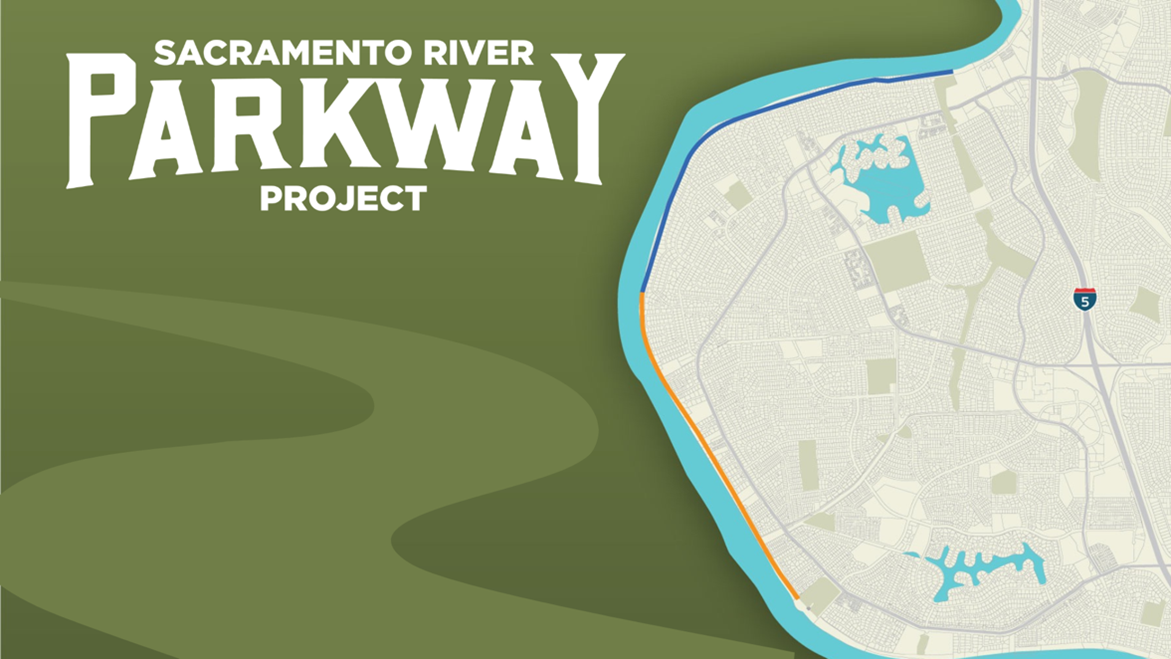
The Sacramento River Parkway Project is a multi-phase project to complete a levee top trail through the Pocket neighborhood. The trail will run along the top of the levee of the Sacramento River, between Garcia Bend Park and Zacharias Park. The project is being designed to be constructed in two segments, depending on funding availability. The first stage of the project is from Garcia Bend Park to Arabella Way, and the second stage is from Arabella Way to Zacharias Park.
SRPP quick facts
What’s happening now? Preliminary design and environmental clearance.
How long will that take? Environmental clearance typically takes 18 months, but will vary depending on the findings.
What is under construction right now? The US Army Corps of Engineers is constructing levee improvements. For more information, visit the Sacramento River Levee upgrades website.
The project will include:
- Construction of a paved ADA-compliant levee top trail between Garcia Bend Park and Zacharias Park.
- ADA-compliant access ramps at locations along the trail.
- Improved connections between the Pocket Canal Parkway and the Sacramento River Parkway Project.
- The development and implementation of the Sacramento River Parkway Project neighborhood safety plan.
Current status of public access
The Sacramento River levee top through the Pocket neighborhood has a mix of public- and private-ownership.
The levee top south of Aquapher Way (just north of the Pocket Canal Sump Station) to the Freeport Regional Water Authority Intake Facility is public property, and the existing paved trail begins at Garcia Bend Park and runs down stream to the south.
North of Aquapher Way is a mix of public and private ownership of the levee top. The privately-owned segments of the levee top typically provide easements for flood control and maintenance activities, but do not include easement for public access. The locations of private ownership may or may not have cross-levee fences to delineate their locations, but a lack of fence does not indicate a right to public access along the top of the levee and must not be trespassed. (Note: requests for cross-levee fences are submitted to, reviewed, and approved by the Central Valley Flood Protection Board. The City of Sacramento does not have jurisdiction over cross-levee fences) The City of Sacramento will work with potentially affected property owners to obtain any necessary rights to public access the proposed trail, following completion of the environmental reviews, project approvals, and prior to the construction of the trail.
Sacramento river parkway project history
The vision for a riverfront trail has been in plans for nearly 50 years. The Sacramento River Parkway was first envisioned in the 1975 Sacramento River Parkway master plan and was subsequently added to the 1979 Pocket Area Community plans. The Parkway plan was revisited with the 1997 Sacramento River Parkway plan update. In the 1997 update, a preferred trail alternative was identified, locating the trail on top of the Sacramento River Levee.
In 2012, the City created an implementation plan to further the Sacramento River Parkway project.
In 2015, the Public Works Department began initial work toward an early phase of the Sacramento River Parkway Project, focusing on the limits between Garcia Bend Park and the Pocket Canal. In 2017, the City Council appropriated additional funds for the next segment of the project, analyzing the trail up to Arabella Way.
While initially envisioned to be constructed in small segments using local funds. In 2020, the decision was made to apply for federal funding. The project was awarded federal funds allowing the project to be designed and constructed in larger segments. This would also reduce construction impacts on neighborhoods and enable the entire trail to be completed sooner. The City of Sacramento applied for federal funding from the regional allocation programmed by the Sacramento Area Council of Governments (SACOG) in 2021. SACOG has provided funding to complete the preliminary engineering and environmental clearance and prepare the final design.
The project will require right-of-way acquisitions and/or easements from private property owners at some locations along the project alignment. The right-of-way process will begin only after the completion of environmental clearance. Additional funding will be pursued for right-of-way work for both segments (between Garcia Bend Park and Zacharias Park) and the construction of both phases. In early 2022, the City began preliminary engineering, design, and environmental clearance; to develop subsequent plans, specifications, and estimates (PS&E) and acquire the right-of-way (ROW) required for both segments of the trail.
The current work underway includes the development of a project schedule and work plan which incorporates surveying, preliminary engineering, design, and geotechnical studies. Other activities involve assembling the necessary studies to create comprehensive environmental reports consistent with the California Environmental Quality Act (CEQA) and the National Environmental Protection Act (NEPA).
With the current grant funds available, the project will specifically address the Preliminary Engineering, Environmental Clearance, and Final Design for both Segments. Additionally, they are addressing right-of-way services for Segment 1 while pursuing additional funding for right-of-way services for Segment 2. The following is an overview of the broad categories of work the project team will perform during this phase of the project:
Survey and data collection
Survey work began in April 2022. This includes project site visits, walking the levee at locations to take measurements, and using drone technology to establish the site's topography without impacting private property or the ongoing levee construction project. Additional field topographic surveys will occur at a later stage of design after the completion of the levee improvements. Other tasks include reviewing title reports and right-of-way exhibits to understand property ownership along the project alignment.
Design
The Sacramento River Parkway Project will provide the community access to the new trail by creating new ADA-compliant ramps at several locations. The project team will evaluate many potential access points and consider many factors, including connections to other trails and bike routes, impacts on trees or rights-of-way, and potential impacts on parking. Community input will be included in selecting access points to the Sacramento River Parkway.
The project will also include the development of a safety plan.
Preliminary engineering
Preliminary engineering services will include:
- Conceptual layout of the proposed alignment
- Identification of potential environmental constraints
- Development of landscaping concepts at access points
- Providing ADA compliance at ramps
- Review of the existing and proposed right-of-way
The engineering work will include coordination with utility partners and other public agencies, geotechnical studies, permit coordination, and preparing cost estimates for construction.
Environmental review
The Sacramento River Parkway Project is required to obtain environmental clearance through the California Environmental Quality Act (CEQA), and because the project was awarded federal funding, the National Environmental Policy Act (NEPA). As part of the environmental clearance process, the project will study its potential environmental impacts through the completion of various technical studies. It will document the findings in compliance with both CEQA and NEPA.
Following the completion of the preliminary engineering and environmental clearance, the project team will begin the final design phase, which will prepare the Plans, Specifications, and Estimates (PS&E) for construction.
Public outreach
Throughout the duration of the Sacramento River Parkway Project, we will conduct outreach with the community to obtain input and create opportunities to discuss and receive feedback on the project design, and answer questions. The outreach program will seek input on the potential access ramp locations and design, operations of the parkway, as well the development of the safety plan. We have planned for small group meetings with property owners, community and open house format meetings, digital and traditional forms of communication, and the use of tools that allow for community-wide input on the design of the Sacramento River Parkway Project.
Questions or comments?
SacRiverParkway@CityofSacramento.org
916-808-1705