Active Transportation
Active transportation refers to human-powered methods of travel, including walking, biking, using a wheelchair, scootering, or even skateboarding. The City of Sacramento is working towards becoming a more walkable, bikeable, and rollable city to enhance the quality of life for residents of all ages and abilities.
Some of this work includes expanding and improving active transportation infrastructure such as sidewalks, crosswalks, and bike lanes. Creating a safe, connected, and accessible transportation network for all provides residents with more access to everyday destinations and supports the Sacramento 2040 General Plan goals around climate and mobility. Learn more about the City's active transportation efforts on this page!
Streets for People Plan
City Council adopted the Streets for People: Sacramento Active Transportation Plan at the end of 2025. This citywide initiative addresses active transportation needs and focused its community engagement efforts in underresourced areas that currently lack basic transportation infrastructure. The Plan includes recommendations to improve walking, rolling, and bicycling in Sacramento and will guide future City and private development investment.
Click here to read the plan, plus more context about the planning process
View the S4P Network Map to view city-wide active transportation facilities
Walking in the City
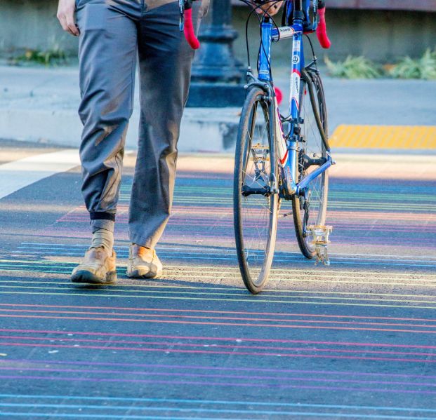
Sacramento's walking environment includes sidewalks, shared use paths, and crosswalks.
New sidewalks and crosswalks are typically built by developers as a part of new development projects or by the City through grant-funded corridor improvement projects. Most funding for transportation projects comes from competitive grants, so new sidewalks are rarely developed by themselves.
The City may install new crosswalks after evaluating a potential cross site for multiple variables including speed, average daily traffic, and roadway geometry. Read more about the City's guidelines for evaluating potential cross sites in the "Walking Resources" section below.
The City of Sacramento is also in the process of updating its policy and guidance for the Creative Crosswalks Program, a program which infuses public art into the active transportation infrastructure through partnerships with local organizations; see the link below for current program guidelines.
Shared use paths are paved pathways - separate from the street - that can be shared by people walking, rolling, bicycling, scooting, and skating. Similar to new sidewalks and crosswalks, these paths are typically built through new development projects or through a competitive grant program.
Read about the City's guidelines for evaluating potential cross sites (2021)
Design and Implementation guidelines for new and existing crosswalks (2021)
Read the Program Handbook for the City's guide to a more walkable Sacramento.
Criteria and guidelines that conform to current state and federal rules
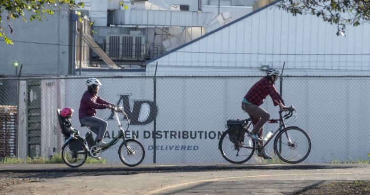
Bicycling and Scooting in the City
The City has a variety of bicycle infrastructure, or "bikeways", including shared use paths and on-street bike lanes. In addition to bicycles, this infrastructure serves many types of manual and electric modes of transportation such as skateboards and scooters.
New bikeways are built based on a citywide bicycle plan, which was recently updated through the Streets for People Active Transportation Plan. They are typically funded through competitive grant programs or occasionally large development projects.
Existing bikeways are maintained in a number of different ways; the Street Maintenance team sweep and repair shared use paths and the Recycling and Solid Waste team sweep the city’s gutters and on-street separated bikeways.

No bike? No problem! Shared-rideables, or shared micromobility devices such as motorized scooters, are available for rent throughout the city. The City of Sacramento issues permits to shared micromobility companies operating in the city and conducts regular evaluations of operations and regulations.
Educational classes on how to ride your personal vehicle safely and legally
Resources for understanding the rules for electric micromobility options
Read more about the City's role in permitting shared micromobility operations
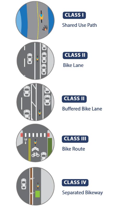
Types of Bikeways
Bikeways are categorized by Class I through IV in the California Streets and Highways code section 890.4. Take a look at each type of bikeway shown and described below.
- Shared Use Paths (Class I) are completely separated from the street and are shared with people walking and rolling.
- Bike Lanes (Class II) provide space for people to ride bikes and scooters outside of the travel lane.
- Buffered Bike Lanes (Class II) are lanes for those biking and scooting with a painted buffer separating the bike lane from the travel lane.
- Bike Routes (Class III) are streets designated for bicycle travel where those biking and those driving are sharing the same lane. Bike routes are typically on low speed, low volume streets and have signs.
- Separated Bikeways (Class IV) are separated from the travel lane with a physical separation such as parked cars, planters, curbs, or bollards and can be used by those biking and scooting.
Separated bikeways (Class IV) are typically on streets with higher traffic volumes and speeds. Separation types can range from painted buffers and flexible delineators (like on 19th Street and 21st Street here in Sacramento), to more substantial barriers including concrete curbs. Sacramento’s specific designs are based on State and Federal design standards, with technical expertise and community input helping to guide specific designs for each street.
There are numerous benefits of separated bikeways, including:
- Creating safer conditions, including providing better safety outcomes for all modes of travel including walking, biking, and driving (Marshall and Ferenchak, 2019), reducing the risk of crashing between people bicycling and driving (Lusk et. al, 2013), and reducing the risk of crashes by 50% compared to standard bike lanes (Harris et. al, 2013)
- Encouraging more people to shift to active transportation, including increasing the overall number of people bicycling (Buhler and Dill, 2015), increasing the number of women who bicycle (Dill et. all, 2014), and increasing the number of bikers at a higher rate than standard bike lanes (Monsere et. al, 2014 )
- Supporting and even boosting the local economy (Liu, 2019)
A printable map of all the existing bikeways in the city (Updated Summer 2025)
An interactive look at the City's existing and planned bike and ped facilities
Find the schedule for services in your neighborhood including street sweeping
Bike Parking
The City also has electronic bike lockers (eLockers) and a bike SPA (Secure Parking Area) at the Sacramento Valley Train Station, in addition to city-owned parking garages including Tower Bridge, Memorial Auditorium, City Hall and Capitol garage. To use the eLocker (costing 5 cents an hour), you must purchase and activate a BikeLink card in advance. Cards are available online and at the ticket counter at the station.
In an effort to expand the network of publicly available, long-term bike parking in the city, staff has recently launched a Secure Bike Parking Pilot to identify new locations for secure bike parking citywide. Click here to learn more about the pilot.
Updated map with both City-owned and private bicycle parking locations
Link to purchase a BikeLink card, link a transit card, or download the app
Link for more info on the bicycle Secure Parking Areas
The City's standards for bicycle parking design and placement, adopted in 2017
Learn how to request new bike parking facilities on public or private sites
Stay in the Loop

Active transportation projects in the planning phase

Projects in the design, environmental review, or construction phase

Sign up for the Transportation Planning Newsletter

Attend Active Transportation Commission meetings virtually or in person