
102-Acre Site Frequently Asked Questions
What is the 102-acre site?
The 102-acre site is a vacant, City-owned property at 3100 Meadowview Road in south Sacramento. On September 29, 2026, the City Council declared the property surplus land, beginning the process required by the California Surplus Land Act. The declaration did not approve a sale or a specific development project.
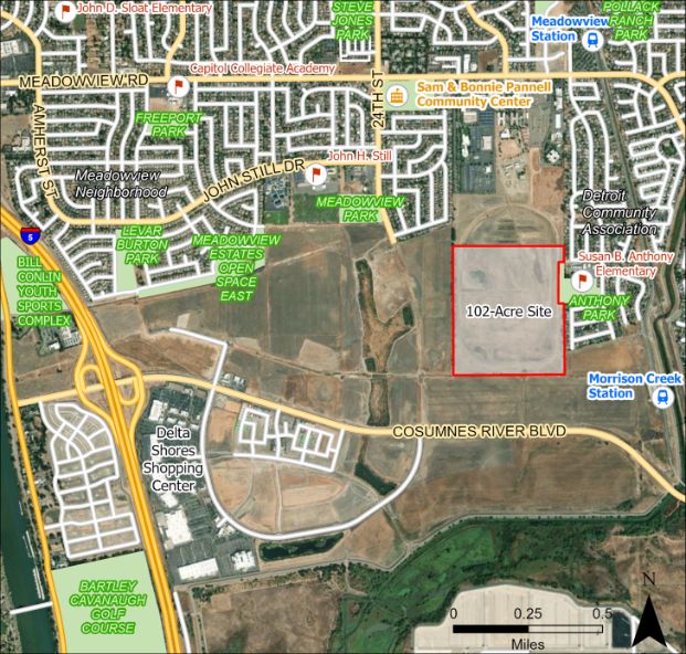
The 102-acre site is between Meadowview Road and Consumnes River Boulevard
How did the City acquire the site?
The City purchased the site from the U.S. Department of Labor for $12.3 million in January 2022.
Why did the City purchase the site?
The City purchased the site because Council saw there was short-term potential for the site to provide for a safe parking site for unhoused neighbors in the short-term and a long-term potential to develop in a way that served the surrounding community.
Why did the City conduct an opportunities and constraints analysis?
The City completed the analysis to inform the public and City Council about the site’s existing conditions, potential land uses, development constraints, infrastructure needs, and financial feasibility. The analysis evaluated four preliminary land-use scenarios and found that development would require substantial upfront investment, including at least $50 million for roads, utilities, and other basic infrastructure.
The analysis did not select a final development plan. It provided information for Council decision-making and for the City’s subsequent market outreach.
What did the analysis find about the site's initial conditions?
- Past users disturbed the site, having moved soil around to build a driving track for the California Highway Patrol and dug a stormwater catchment pond, both of which are present today.
- While past users disturbed the site from a “natural” condition, the man-made stormwater pond and seasonal wetlands trigger State and/or federal oversight.
- The site provides suitable habitat for some special status species, including Swainson’s hawk and vernal pool fairy shrimp, though it is unclear if these species are present at the site at this time.
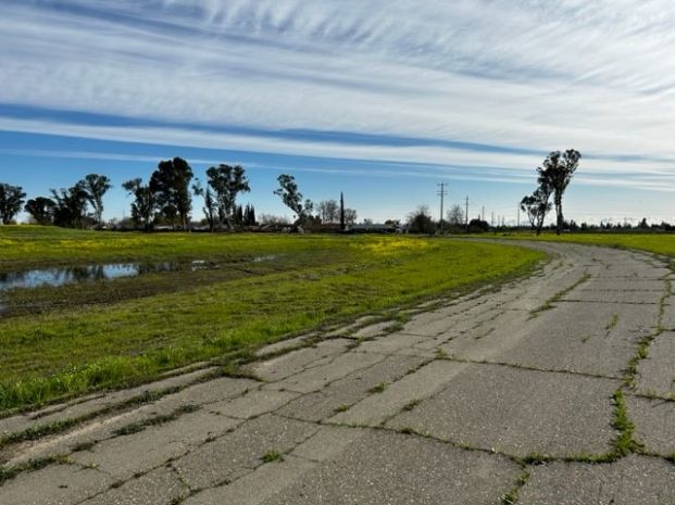
The site has a driving track from past users.
What are the results from the market study regarding feasible land uses that could be developed on the site?
The market study found that some uses had more demand than others, due to the site’s location and proximity to other existing and planned uses. Table 1, below, indicates the uses (with stars) that were included in the land use concepts for additional investigation.
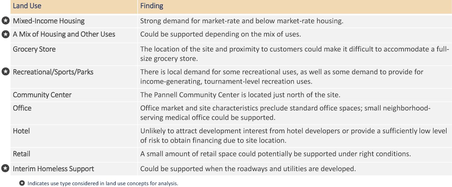
Table-1 Land Use Market Study Findings
What land use concepts were studied in more detail?
Based on community input on desirable land uses as well as a planning charette and a market study, the following concepts were created.
- Concept 1: All sports/recreation uses.
- Concept 2a: A mix of sports/recreation, residential, and wetland preservation uses.
- Concept 2b: A mix of sports/recreation and residential uses, but no wetland preservation.
- Concept 3: All residential uses.
Please note that these concepts are not the only ones possible; however, the goal was to provide concepts that represented the most likely land use types as well as being conservative in terms of what scenarios would have the highest costs to the City. The proportion and placement of the land uses may change; however, due to State law regarding the sale or lease of City-owned land as well as the findings of the market study, it’s likely that the final use for the site would include one or more of the represented land uses: residential, sports/recreation, parks, and open space.
What assumptions did the analysis consider in order to evaluate the costs and revenues associated with each potential concept?
To calculate the potential costs and revenues, the analysis had to make certain assumptions. If any of these assumptions were to change, the costs and revenues would also change.
Development Process. The analysis assumed:
- City provides necessary approvals for a development plan before sale.
- City mitigates for environmental impacts.
- City develops the main (backbone) infrastructure, such as key roadways, sewer and water mains, and detention basins.
- City develops and operates a sports/recreation complex or a neighborhood park.
Costs. The analysis assumed:
- One-time development costs, including backbone infrastructure, mitigation costs, and construction of public amenities.
- Cost sharing of off-site infrastructure with adjacent developments.
- Ongoing operations and maintenance over a 30-year period.
Revenues. The analysis included:
- One-time land sale of residential.
- Sports/recreation complex revenue from Transient Occupancy Tax (TOT), sales tax, and use fees over a 30-year period.
What are the results for costs and revenues for each concept and how should these findings be interpreted?
- Concept 1: All sports/recreation uses results in negative net revenue.
- Concept 2a: A mix of sports/recreation, residential, and wetland preservation uses results in negative net revenue; however, this would be less negative than Concept 1.
- Concept 2b: A mix of sports/recreation and residential uses, but no wetland preservation results in negative net revenue; however, this would be less negative than either Concept 1 or Concept 2a.
- Concept 3: All residential uses results in positive net revenue.
Concepts 1, 2a, and 2b assume the City would develop and operate a sports/recreation complex, whereas Concept 3 assumes the City would develop and maintain a neighborhood park. If the size of the complex was different or if there were a private developer or operator, the costs and revenues could change substantially.
What are the estimated costs and revenues for each concept?
Depending on the land use scenario, the following costs and revenues were estimated (in 2023 dollars):
- The estimated costs for on-site development range from approximately $40 million to $123 million depending on the mix of land uses and the intensity of their infrastructure demands. Residential uses require more infrastructure than sports and recreation uses.
- The estimated costs for off-site utilities, roadways, and storm drainage range from approximately $4 million to $13 million depending on the mix of land uses and the intensity of their infrastructure demands. Residential uses require more infrastructure than sports and recreation uses.
- The estimated revenue over 30 years from a City-owned and -operated sports/recreation complex ranges from approximately $3 million to $8 million, depending on the size of the complex.
- The estimated revenue from the sale of entitled residential land ranges from approximately $23 million to $86 million, depending on the amount of residential land.
- The overall net revenue over 30 years is estimated to range from a loss of approximately $120 million to a gain of up to $34 million depending on whether there is a sports complex, the size of the sports complex, and the amount of residential land.
What will the site be used for?
The City Council’s September 29, 2026, action did not select a development proposal or determine the site’s future use. The site could include homes, parks and recreation, businesses, open space, trails, or other uses, guided by City Council’s direction on the general types of uses; however, the specific uses that end up on the site will depend on several factors, including policy direction from City Council, market feasibility, and available funding.
The City is responsible for regulating private development, determining the general types of uses, such as residential, commercial, and parks, on a site and providing a framework for what specific types of uses would be allowed. The City may build infrastructure and community amenities, such as parks or community centers. The City may encourage or incentivize specific uses on the site.
How much time will development take?
Development of a large site with environmental constraints, limited access, and no existing infrastructure will take many years. The earlier analysis estimated that planning, entitlement, environmental review, permitting, and construction would take at least six years. The Surplus Land Act process occurs before a development plan is known and will add time to the overall schedule.
At minimum, the following steps would need to occur:
- Complete the Surplus Land Act process, including a Notice of Availability that remains open for at least 60 days and, if a qualified entity submits a notice of interest, at least 90 days of good-faith negotiations.
- . Obtain City Council review and approval of any proposed disposition or development action.
- Complete planning and entitlement for the site.
- Review potential environmental impacts.
- Obtain required State and federal permits for work in protected environmental areas.
- Design and construct the necessary infrastructure and buildings.
The timing and sequence may change depending on the outcome of the Surplus Land Act process and any future proposal. Community priorities will continue to inform the City’s evaluation of future opportunities.
Are there any restrictions on the sale or use of the site?
On September 29, 2026, the City Council declared the property surplus land. The City must now follow the California Surplus Land Act before it may dispose of the property. The process gives priority to qualified entities proposing affordable housing.
The declaration did not approve a sale, lease, or development project. Any future development must also comply with the City’s General Plan, zoning regulations, environmental review requirements, and other applicable laws.
I noticed that the site does not have any roadways to it. How will the development be accessed?
The site is adjacent to federally owned property to the north. No permanent roadway access is available through the federal property. To the east, there are a few potential locations for pedestrian and bicycle access, and potentially for emergency vehicle access. To the south, is a planned development called Stone Beetland, which includes a plan for an east-west roadway that could potentially connect the 102-acre site through north-south roadways. Lastly, to the west, the planned development called Delta Shores is expected to include a north-south extension of 24th Street, and will provide a connection point to the 102-acre site.
What are the immediate next steps for the site?
On September 29, 2026, the City Council declared the property surplus land, beginning the process required by the California Surplus Land Act.
The City will issue a Notice of Availability, which must remain open for at least 60 days. If a qualified entity submits a notice of interest, the City must negotiate in good faith for at least 90 days. If the City does not reach an agreement through that process, it may consider other disposition options consistent with State law.
The surplus declaration did not approve a sale or a specific development project. Any future disposition or development action will require separate review and approval by the City Council.
What can residents do to express their needs/wants related to the development of the site?
Residents may continue to share their priorities for the site and stay informed by:
- Submitting a comment through the project website;
- Signing up for the project email list; and
- Participating in future public meetings and City Council consideration of the site.