Central City Mobility Project
Central City Mobility project map
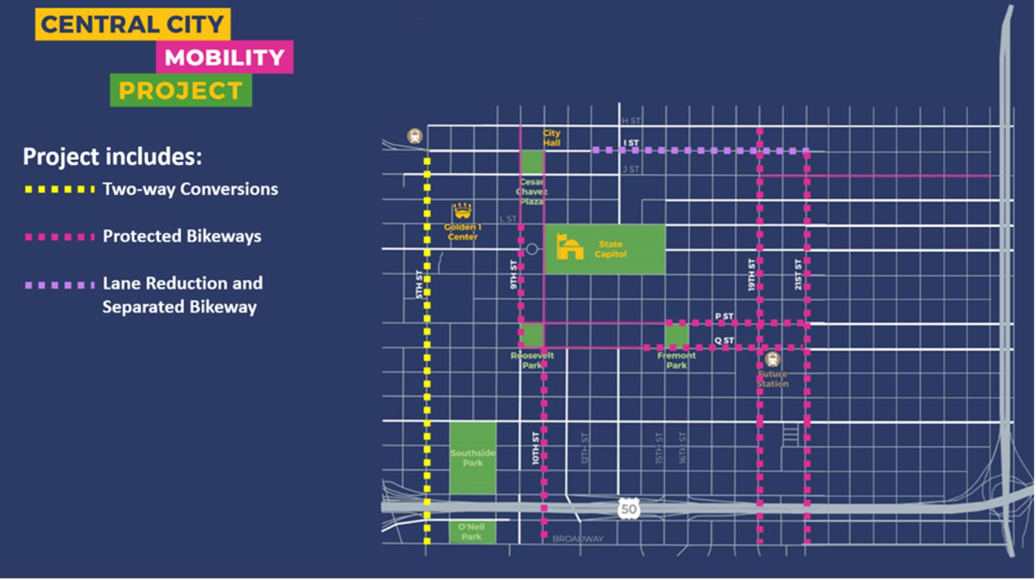
The Central City Mobility Project (formerly Downtown Mobility) is expanding the protected bikeway network on the grid and implementing traffic circulation changes to enhance travel options for all modes. This project is an implementation of the recommended mobility improvements outlined in the Central City specific plan, which aims to improve connections in the urban center for biking, walking, and transit.
Project hotline
916-314-6339
SacramentoMobilityProject@gmail.com
Click below (or keep scrolling) for information about:
Project description
Two-way conversion
5th Street will be converted from a one-way to a two-way street, between Broadway and H Street, and bike lanes will be added in both directions.
Protected bikeways
The project will extend the protected bikeway network on:
- 9th Street (Q Street to L Street)
- 10th Street (Broadway to Q Street),
- 19th Street (H Street to Broadway),
- 21st Street (I Street to Broadway),
- P Street (15th Street to 21st Street), and
- Q Street (14th Street to 21st Street).
The improvements on I Street will include a reduction from 3 lanes to 2 lanes, to provide space for the bicycle facilities.
Community meeting November 2022
On Thursday, November 10, 2022, the City of Sacramento hosted a community workshop about the Central City Mobility Plan at the Capitol Events Center. Community members had a chance to hear project updates and provide feedback prior to construction.
Project features
Two-way conversion
Changes to the lane configurations: N/A
Protected bikeways
Changes to the Lane Configurations: N/A
Note: Bikeways will be on the left side of the street (with regards to the direction of vehicle travel) on 9th Street, 19th Street, 21st Street, P Street, and Q Street, to avoid conflicts with bus stops. Bikeways will be on the right side of the street on 10th Street and I Street.
Turn wedges and intersections
The project will install “turn wedges” at intersections to slow vehicles turning across the bikeway.
Bikeway transitions
The side of the street selected for the bikeways was chosen to minimize conflicts with bus routes and driveways/intersections. There are some locations where the bike facility must transition from one side of the street to the other, to conform to the existing street configuration. At these locations, the bicyclist will use a two-stage turn box to make the transition:
Why bikeways and two-way conversions?
Studies have shown that many people are interested in riding bikes to get around, but have concerns about riding next to moving vehicle traffic. These “interested but concerned” people benefit from protected bikeways, which provide separation from moving cars. Providing bike facilities that are comfortable for a wide range of users will help Sacramento provide equity in transportation choices, and support our efforts to reduce air pollution and greenhouse gas emissions.
A two-way conversion on 5th Street will provide bi-directional access for both cars and bicyclists, linking Upper Land Park, Broadway, Southside Park, Downtown, and the Railyards. It will also calm traffic, as two-way streets generally have lower vehicular speeds than one-way streets.
Parking changes and City services
The installation of protected bikeways and the two-way conversion will require some changes to parking. There are a few reasons that parking may be changed:
- Parking-protected bikeways require parking restrictions near driveways and intersections to provide visibility to bicyclists who may be riding behind parked vehicles.
- The project will restrict parking adjacent to crosswalks to provide improved visibility to crossing pedestrians.
- Parking restrictions will also be enforced near fire hydrants.
- At isolated locations, parking may be eliminated to provide space for a bike lane.
For residents with city services (including trash and leaf pile collection), bins and leaf piles should be placed within the buffer space between the parking stall and bikeway, or the buffer space at the ends of the parking aisles. At these locations, the buffer space will be wider than typical, to provide more space for the bins and piles. Trash bins and leaf piles should not be placed against the curb or in the bikeway.
Most of the streets within the project limits already have parking restrictions on City services days, which will allow the collection vehicles to access the bins and piles in the buffer space. On 10th Street, between V and Q Street, new parking restrictions on City services days will be implemented, to allow for that access.
The Division of Recycling and Solid Waste is incorporating the bikeway locations into the route of our bikeway sweepers.
Construction schedule
Construction will begin in Spring 2023 and is anticipated to last for approximately 12 months. This webpage will be updated with more information when the construction contract is awarded and contractor scheduling is available.
Funding and project cost
The City received a $5 million grant through the competitive Local Partnership Program (SB1) for construction of the improvements on 9th Street, 10th Street, P Street, Q Street, 5th Street and I Street. The City also entered into an agreement for $3 million in TIRCP (Transit and Intercity Rail Capital Program) funds with the San Joaquin Regional Rail Commission and San Joaquin Joint Powers Authority (SJRRC) as part of their Valley Rail project, to design and construct the protected bikeways on 19th Street and 21st Street to serve their proposed Midtown station. Additional funding for the construction of bikeways on 19th Street, 21st Street, P Street and Q Street was awarded through a $2.5 million grant through the Affordable Housing & Sustainable Community Program. Project design and grant match are funded through the Downtown Impact Fees and Transportation Development Impact Fees, and pavement rehabilitation will be supplemented with RMRA (Road Maintenance and Rehabilitation Account)(SB1) funding.
The anticipated construction cost for the project will be approximately $12.6M.
Getting around during construction
The construction of this project will affect several streets. Other projects, including the Broadway Complete Street project and other private development projects, will also impact traffic operations. Information about timing for lane closures and other construction traffic control measures will be provided when construction starts in early 2023.
Residents, motorists, and other users of the affected roadways can expect intermittent delays, sidewalk closures, and lane closures throughout the construction effort. This project affects multiple road corridors within the Central City area. The contractor is expected focus construction efforts and traffic control (lane closures) on 1-2 roadways concurrently so these impacts to the public will shift around to different locations throughout the construction phase.
Options for getting around:
Transit:
Light rail service will be unaffected by construction activities. Use the Regional Transit’s trip planner to help identify the best transit options.
Bicycling:
Reference the bike map to plan out your trip (although make note of streets with construction).
Unsure where to lock your bike? Search for bike racks.