- City Departments
-
-
Community Development
-
Community Response
-
Convention and Cultural Services
-
Finance
-
Fire Department
-
Human Resources
-
Information Technology
-
Mayor and Council
-
Office of Public Safety Accountability
-
Office of the City Attorney
-
Office of the City Auditor
-
Office of the City Clerk
-
Office of the City Manager
-
Office of the City Treasurer
-
Police Department
-
Public Works
-
Utilities
-
Youth, Parks, & Community Enrichment
-
- Browse by categories
-
-
hiking Activities
-
pets Animals & Pets
-
domain_add Building & Planning
-
store Business
-
account_tree City Administration
-
category City Assets & Data
-
explore City Regions
-
diversity_4 Community Support
-
theater_comedy Culture & History
-
business_center Employment
-
directions Infrastructure
-
gavel Law, Code & Compliance
-
payments Money
-
park Outdoors & Sustainability
-
local_police Safety
-
directions_car Transportation
-
delete_sweep Utility Services
-
Use the menus above to navigate by City Departments or Categories.
- Convention and Cultural Services
- Arts and Culture
- Convention and Cultural Services
- Convention and Cultural Services
- Convention and Cultural Services
- Convention and Cultural Services
- Home
- Entertainment Services Division
- Arts and Culture
- Arts and Culture
- Arts and Culture
- Mayor McCarty Memo
- Arts and Culture
- Arts and Culture
- Convention and Cultural Services
- SVS Connectivity Projects
- Access Leisure
- Recreation
- Recreation
- Recreation
- Youth, Parks, & Community Enrichment
- Public Art Projects
- Community Engagement
- Community Engagement
- About YPCE
- Hart Senior Center
- Recreation
- Youth Workforce Development
- Older Adult Services
- Youth, Parks, & Community Enrichment
- Long Range
- Public Art
- Youth, Parks, & Community Enrichment
- Recreation
- Recreation
- Recreation
- Home
- Youth, Parks, & Community Enrichment
- About YPCE
- About YPCE
- Older Adult Services
- Recreation
- Home
- Parking
- Innovation and Grants
- Aquatics
- CCS Partners
- Convention and Cultural Services
- Public Art
- Community Engagement
- Office of Public Safety Accountability
- Public Art Projects
- District 7 - Rick Jennings
- Request a Permit
- Convention and Cultural Services
- CCS Partners
- Fire Department
- About YPCE
- Recycling & Solid Waste
- River District Specific Plan
- Convention and Cultural Services
- CCS Partners
- CCS Partners
- Mayor Kevin McCarty
- District 5 - Caity Maple
- Commercial Waste Services
- Entertainment Services Division
- Entertainment Services Division
- Home
- Recreation
- Access Leisure
- Recreation
- Recreation
- Recreation
- Specialty Parks
- Mayor McCarty Memo
- Specialty Parks
- Permits for YPCE
- Recreation
- Youth, Parks, & Community Enrichment
- About YPCE
- Youth, Parks, & Community Enrichment
- Aquatics
- Recreation
- Home
- Animal Care
- Animal Care
- Community Development
- Animal Care
- Animal Care
- Animal Care
- Animal Care
- Animal Care
- Animal Care
- Specialty Parks
- Animal Care
- Animal Care
- Street Landscape Maintenance
- Accessory Dwelling Units
- City Government
- Community Development
- Building
- Contact CDD
- Building
- Building
- Building
- Building
- Business Waste Requirements
- Commercial Waste Services
- Maintenance Services
- Procurement Services Division
- Parks
- Utilities
- Public Works
- Engineering
- Fire Prevention
- Building
- Building
- Building
- Building
- Engineering
- Home
- Public Works
- Housing
- Engineering
- Housing
- Planning
- Fire Prevention
- Contact CDD
- Building
- Recycling & Solid Waste
- Fire Prevention
- Fire Prevention
- Community Development
- Community Development
- Building Programs
- Community Development
- Locate & Grow in Sacramento
- Planning
- Permit Services
- Planning
- Planning
- Climate Action Initiatives
- Planning
- Planning
- Public Works
- Parks
- Community Development
- Community Development
- Planning
- List of City Manager's Office Projects and Programs
- Public Works
- Planning
- Planning
- Public Works
- Mobility and Sustainability
- Transportation
- Planning
- Planning
- City of Sacramento Public Art Forms & Policies
- Engineering
- 102-Acre Site
- Major Planning Projects
- Community Development Meetings and Hearings
- City of Sacramento Public Art Forms & Policies
- Locate & Grow in Sacramento
- Major Planning Projects
- Planning
- City Government
- Innovation and Economic Development
- Code Compliance
- Revenue Division
- Revenue Division
- Innovation and Economic Development
- Finance
- Recycling & Solid Waste
- Entertainment Services Division
- Business
- Business
- Procurement Services Division
- Mayor McCarty Memo
- Revenue Division
- Business
- Major Planning Projects
- City Auditor Reports
- City Auditor Reports
- Cannabis Management
- Cannabis Management
- Cannabis Management
- Business Operations Tax
- Cannabis Management
- Finance
- Cannabis Management
- City Auditor Reports
- Cannabis Management
- Major Planning Projects
- Parking
- COVID-19 Programs
- Transportation Projects
- Innovation and Economic Development
- Innovation and Economic Development
- Business
- Public Art
- Community Engagement
- Innovation and Economic Development
- Innovation and Economic Development
- Innovation and Economic Development
- Transportation
- Innovation and Economic Development
- Office of the City Manager
- Business
- Business
- Innovation and Economic Development
- Innovation and Economic Development
- Mayor McCarty Memo
- Business
- Innovation and Economic Development
- Information Technology
- Information Technology
- Public Art
- Office of the City Manager
- Business
- Finance
- Accounting Division
- Police Services
- Procurement Services Division
- City Government
- Public Art
- Code Compliance Programs
- Code Compliance Programs
- Commercial Waste Services
- Procurement Services Division
- Procurement Services Division
- Home
- Commercial Waste Services
- Procurement Services Division
- Finance
- Finance
- Procurement Services Division
- Procurement Services Division
- Office of the City Auditor
- Police Transparency
- Office of the City Auditor
- Office of the City Auditor
- Accounting Division
- Office of the City Clerk
- City of Sacramento Public Art Forms & Policies
- Home
- About YPCE
- Arts and Culture
- SVS Projects - Current, Past, and Future
- Diversity and Equity
- Records Management
- Office of the City Auditor
- Director Hearings
- Director Hearings
- Director Hearings
- Director Hearings
- District 1 - Lisa Kaplan
- District 2 - Roger Dickinson
- City Auditor Reports
- Office of the City Clerk
- City of Sacramento Public Art Forms & Policies
- About YPCE
- Police Transparency
- Home
- Records Management
- Office of the City Manager
- Office of the City Manager
- Neighborhood Directory
- Neighborhood Directory
- Community Engagement
- Public Art
- Office of the City Manager
- Innovation and Grants
- Office of the City Manager
- Office of the City Manager
- Office of the City Manager
- Home
- River District Specific Plan
- Public Art
- City Government
- Engineering
- City Government
- Long Range
- City Government
- City Government
- City Government
- City Government
- Information Technology
- Information Technology
- Camp Sacramento
- Public Art
- Parking
- About YPCE
- Finance
- Drinking Water Quality
- Utilities
- Permit Services
- Office of Public Safety Accountability
- Pay Your Utility Bill
- Police Services
- Police Services
- Marina
- Police Services
- Contact Us
- Police Services
- Office of the City Clerk
- Home
- Public Art
- Mayor and Council
- Mayor and Council
- Mayor and Council
- Mayor and Council
- Mayor and Council
- Mayor and Council
- Mayor and Council
- Mayor and Council
- Mayor and Council
- Office of the City Clerk
- Mayor and Council
- Home
- Diversity and Equity
- Office of the City Clerk
- Office of the City Auditor
- Office of Public Safety Accountability
- About the City Attorney's Office
- Office of the City Auditor
- Office of the City Auditor
- Police Department
- Maps and Geographic Information Systems
- Office of Public Safety Accountability
- Police Department
- City Government
- Office of the City Auditor
- Sacramento for All: Housing Education Resource Center
- 102-Acre Site
- 102-Acre Site
- 102-Acre Site
- Public Art
- Public Works
- Construction & Demolition Recycling
- About SPD
- Facilities & Real Property Management
- Public Works
- Adult Sports Activities and Resources
- Climate Action Initiatives
- Fleet Services
- Public Works
- Director Hearings
- Director Hearings
- Director Hearings
- Director Hearings
- Director Hearings
- Director Hearings
- General Plans
- Police Transparency
- Convention and Cultural Services
- Public Art
- Legislative Management
- District 1 - Lisa Kaplan
- Home
- Maps and Geographic Information Systems
- Public Art
- Office of the City Clerk
- Office of the City Clerk
- Police Services
- Office of the City Auditor
- Office of Public Safety Accountability
- About the City Attorney's Office
- Office of the City Auditor
- Office of the City Auditor
- Police Department
- Maps and Geographic Information Systems
- Office of Public Safety Accountability
- Police Department
- City Government
- Office of the City Auditor
- Public Art Projects
- Public Art
- Public Art Projects
- Mayor and Council
- Mayor and Council
- Mayor and Council
- Mayor and Council
- Mayor and Council
- Mayor and Council
- Mayor and Council
- Mayor and Council
- Maps and Geographic Information Systems
- City Elections
- Public Art Projects
- Major Planning Projects
- Public Art
- District 5 - Caity Maple
- Public Art Projects
- Police News
- Community Resources and Financial Empowerment
- Community Engagement
- Youth Workforce Development
- Locate & Grow in Sacramento
- Public Art
- Transportation Planning: Current Efforts
- Major Planning Projects
- Public Art Projects
- City of Sacramento Public Art Forms & Policies
- Engineering
- 102-Acre Site
- Major Planning Projects
- Community Development Meetings and Hearings
- City of Sacramento Public Art Forms & Policies
- Locate & Grow in Sacramento
- Major Planning Projects
- Planning
- Youth, Parks, & Community Enrichment
- Specialty Parks
- Long Range
- Public Art
- City Government
- Parking
- Transportation Projects
- About YPCE
- Home
- Engineering Programs & Services
- About OAC
- SVS Projects - Current, Past, and Future
- Youth, Parks, & Community Enrichment
- Maintenance Services
- City Government
- Older Adult Services
- Housing
- Home
- Youth, Parks, & Community Enrichment
- About YPCE
- About YPCE
- Older Adult Services
- Recreation
- Home
- 102-Acre Site
- Sacramento for All: Housing Education Resource Center
- Long Range
- City Auditor Reports
- Public Art Projects
- Central City Specific Plan
- Public Art
- Priority Projects/Investments
- Community Engagement
- Innovation and Economic Development
- Office of Public Safety Accountability
- Diversity and Equity
- Join Sacramento Fire
- Innovation and Economic Development
- District 5 - Caity Maple
- Public Art Projects
- Responding to Homelessness
- Fire Department
- Measure U
- Office of the City Manager
- Police News
- Safety and Crime Prevention Tips
- Youth Workforce Development
- Police Department
- Community Development Meetings and Hearings
- River District Specific Plan
- Diversity and Equity
- Youth Civic Engagement
- Transportation Planning
- Older Adult Services
- Vision Zero: Transportation Safety
- About Access Leisure
- Access Leisure Sports
- Access Leisure Sports
- Cannabis Management
- Office of the City Auditor
- Office of the City Auditor
- Public Art
- Public Art Projects
- Human Resources
- Financial Empowerment
- Home
- Innovation and Economic Development
- Police Community Programs
- Community Response
- Mayor McCarty Memo
- Community Response
- District 5 - Caity Maple
- Workforce Development
- Police Community Programs
- Community Response
- Mayor McCarty Memo
- Community Response
- Housing
- Office of the City Manager
- Planning
- Housing
- Mayor McCarty Memo
- District 5 - Caity Maple
- Housing Development Toolkit
- Permit Services
- City and County Partnership
- Housing Development Toolkit
- Housing
- Housing
- Housing
- City and County Partnership
- Code Compliance
- Housing
- Revenue Division
- Priority Projects/Investments
- Housing
- Long Range
- District 5 - Caity Maple
- District 1 - Lisa Kaplan
- About YPCE
- Older Adult Services
- Recreation
- Older Adult Services
- Youth, Parks, & Community Enrichment
- Youth, Parks, & Community Enrichment
- Older Adult Services
- Housing
- Home
- About the Office of the City Auditor
- Join Sacramento Fire
- Animal Care
- District 7 Resources
- District 1 - Lisa Kaplan
- Community Engagement
- Police Community Programs
- About YPCE
- Police Department
- Youth, Parks, & Community Enrichment
- Specialty Parks
- Aquatics Programs
- Funding and Grants for Arts and Culture
- District 7 Resources
- Youth, Parks, & Community Enrichment
- CCS Partners
- Join Sacramento Fire
- About YPCE
- Aquatics Programs
- Recreation
- Aquatics
- City Auditor Reports
- Police Community Programs
- Youth, Parks, & Community Enrichment
- Public Art Projects
- Youth, Parks, & Community Enrichment
- Police Community Programs
- Youth, Parks, & Community Enrichment
- Youth, Parks, & Community Enrichment
- Recreation
- Recreation
- Youth, Parks, & Community Enrichment
- Home
- Convention and Cultural Services
- Arts and Culture
- Convention and Cultural Services
- Convention and Cultural Services
- Convention and Cultural Services
- Convention and Cultural Services
- Home
- Entertainment Services Division
- Arts and Culture
- Arts and Culture
- Arts and Culture
- Mayor McCarty Memo
- Arts and Culture
- Arts and Culture
- Convention and Cultural Services
- SVS Connectivity Projects
- Parking
- Innovation and Grants
- Aquatics
- CCS Partners
- Convention and Cultural Services
- Public Art
- Community Engagement
- Office of Public Safety Accountability
- Public Art Projects
- District 7 - Rick Jennings
- Request a Permit
- Convention and Cultural Services
- CCS Partners
- Fire Department
- About YPCE
- Recycling & Solid Waste
- River District Specific Plan
- Convention and Cultural Services
- CCS Partners
- CCS Partners
- Mayor Kevin McCarty
- District 5 - Caity Maple
- Commercial Waste Services
- Entertainment Services Division
- Entertainment Services Division
- Home
- Sacramento for All: Housing Education Resource Center
- Sacramento for All: Housing Education Resource Center
- Public Art Projects
- Convention and Cultural Services
- About the City Attorney's Office
- Specialty Parks
- Planning
- City of Sacramento Public Art Forms & Policies
- Public Art
- Public Art Projects
- About Sacramento Fire
- CCS Partners
- Public Works
- Office of the City Clerk
- Police Department
- About Access Leisure
- Access Leisure Sports
- Access Leisure Sports
- Cannabis Management
- Office of the City Auditor
- Office of the City Auditor
- Public Art
- Public Art Projects
- Human Resources
- Financial Empowerment
- Home
- Innovation and Economic Development
- Police Community Programs
- Human Resources
- Human Resources
- Human Resources
- Human Resources
- Home
- Human Resources
- Payroll Division
- Camp Sacramento
- HR Documents & Resources
- Human Resources
- Human Resources
- Home
- District 7 Resources
- Fire Department
- Leisure Enrichment
- Employee & Retiree Benefits
- Youth Workforce Development
- Sacramento START
- Police Services
- About the Office of the City Auditor
- Join Sacramento Fire
- Animal Care
- District 7 Resources
- District 1 - Lisa Kaplan
- Community Engagement
- Police Community Programs
- About YPCE
- Police Department
- Funding and Grants for Arts and Culture
- Youth Workforce Development
- Innovation and Economic Development
- Transportation Projects
- Transportation Projects
- Transportation Projects
- Transportation Projects
- Transportation Planning: Current Efforts
- Utilities
- Utilities
- Utilities
- Utilities
- Utilities
- Utilities
- Utilities
- Home
- Utilities
- Information Technology
- Information Technology
- Information Technology
- Information Technology
- Information Technology
- City Government
- Information Technology
- Information Technology
- Information Technology
- Information Technology
- Home
- Fire Operations
- Information Technology
- Information Technology
- Collection Calendar
- City Government
- Infrastructure Finance Division
- Home
- Infrastructure Finance Division
- Finance
- Infrastructure Finance Division
- Infrastructure Finance Division
- Building Programs
- Utilities
- Utilities
- Fire Department
- Utilities
- Utilities
- Utilities
- Utilities
- Utilities
- Utilities
- Home
- Safety Tips
- Construction Coordination
- Public Art
- Public Art Projects
- Utilities
- Public Works
- Maintenance Services
- Public Works
- Public Works
- Police Community Programs
- Public Art
- Home
- Survey Services
- Maintenance Services
- Maintenance Services
- Maintenance Services
- Maintenance Services
- Collection Services
- Tree Permits and Ordinances
- Public Works
- Transportation
- Mobility and Sustainability
- Engineering
- Transportation
- Transportation
- Park Planning & Development
- Public Art Projects
- Parks
- Public Works
- Transportation Projects
- Parks
- Public Art
- Transportation Projects
- Transportation Projects
- Transportation Projects
- Utilities
- Utilities
- Utilities
- Stormwater Quality
- Utilities
- Utilities
- Utilities
- Stormwater Quality
- Home
- Community Development
- Community Development
- Code Compliance
- Public Art
- Code Compliance
- Community Development
- Code Compliance
- Code Compliance
- Community Development
- Entertainment Services Division
- Fire Prevention
- Construction & Demolition Recycling
- Code Compliance
- Recycling & Solid Waste
- Code Compliance
- Franchise Waste Haulers
- Residential Permit Parking (RPP)
- Code Compliance
- Building Inspections
- Fire Prevention
- Contact CDD
- Building
- Recycling & Solid Waste
- Fire Prevention
- Fire Prevention
- Commercial Waste Services
- Cannabis Management
- City Government
- Recycling & Solid Waste
- Commercial Waste Services
- Disabled Person Parking
- Electric Vehicle Parking
- Fire Code Enforcement
- Police Transparency
- Commercial Waste Services
- City of Sacramento Public Art Forms & Policies
- Contact Parking Services
- Residential Permit Parking (RPP)
- Building Inspections
- Community Development
- Request a Permit
- Request a Permit
- Fire Prevention
- Contact CDD
- Public Records
- Code Compliance
- Revenue Division
- Cannabis Management
- Request a Permit
- Request a Permit
- Public Art
- Engineering
- Request a Permit
- Entertainment Services Division
- Convention and Cultural Services
- Housing Development Incentives
- Entertainment Services Division
- Housing Development Incentives
- Public Works
- Public Works
- Building
- Youth, Parks, & Community Enrichment
- Locate & Grow in Sacramento
- Building
- Request a Permit
- Public Works
- Revenue Division
- Commercial Waste Services
- Entertainment Services Division
- Building Programs
- Mayor McCarty Memo
- Urban Forestry
- Building Inspections
- Planning
- Finance
- Accounting Division
- Home
- Accounting Division
- City Auditor Reports
- Collection Services
- Payroll Division
- Mayor McCarty Memo
- Office of the City Manager
- Finance
- Budget Division
- Budget Division
- Home
- Measure U
- Mayor McCarty Memo
- Access Leisure
- Climate and Sustainability Planning
- Pay Your Utility Bill
- Hart Senior Center
- Recycling & Solid Waste
- Discount Deals
- Water Conservation
- Youth, Parks, & Community Enrichment
- Aquatics
- Finance
- Utility User Tax
- Recreation
- Office of the City Treasurer
- Office of the City Treasurer
- Office of the City Treasurer
- Home
- Office of the City Treasurer
- Parking
- COVID-19 Programs
- Transportation Projects
- Innovation and Economic Development
- Innovation and Economic Development
- Business
- Public Art
- Community Engagement
- Innovation and Economic Development
- Innovation and Economic Development
- Innovation and Economic Development
- Transportation
- Innovation and Economic Development
- Office of the City Manager
- Business
- Business
- Innovation and Economic Development
- Innovation and Economic Development
- Mayor McCarty Memo
- Business
- Innovation and Economic Development
- Small Organization Sustainability Fund
- Small Organization Sustainability Fund
- CORE
- Convention and Cultural Services
- Stormwater Quality
- Funding and Grants for Arts and Culture
- Funding and Grants for Arts and Culture
- Funding and Grants for Arts and Culture
- Economic Gardening
- Entertainment Services Division
- Forward Together Pilot Grant for North Sacramento
- Innovation and Grants
- Recycling & Solid Waste
- Innovation and Grants
- Innovation and Grants
- About OAC
- Engineering
- Youth, Parks, & Community Enrichment
- Infrastructure Finance Division
- Home
- Infrastructure Finance Division
- Finance
- Infrastructure Finance Division
- Infrastructure Finance Division
- Building Programs
- Office of the City Treasurer
- Office of the City Treasurer
- Home
- Office of the City Treasurer
- Building
- Revenue Division
- Cannabis Business Operating Permits
- Recycling & Solid Waste
- Revenue Division
- Development Standards
- Development Standards
- Emergency Medical Services
- Finance
- Community Engagement
- Marina
- Household Hazardous Waste
- City of Sacramento Public Art Forms & Policies
- Public Works
- Community Development
- Utilities
- City Government
- Finance
- Animal Care
- Home
- Revenue Division
- Development Standards
- Marina
- Permits for YPCE
- Revenue Division
- Infrastructure Finance Division
- Home
- Workforce Development
- List of City Manager's Office Projects and Programs
- About YPCE
- Revenue Division
- Budget Division
- Revenue Division
- Revenue Division
- Transportation Planning
- Transportation Planning: Current Efforts
- Public Art Projects
- Transportation Projects
- Climate Action Initiatives
- Housing
- Public Art
- Transportation Planning: Current Efforts
- Public Works
- Transportation Planning: Current Efforts
- Transportation Planning: Current Efforts
- Transportation Projects
- Transportation Planning: Current Efforts
- Transportation Planning: Current Efforts
- Public Works
- Home
- Access Leisure
- Recreation
- Recreation
- Recreation
- Street Landscape Maintenance
- Public Art
- Climate Action and Sustainability
- Climate Action and Sustainability
- Mobility and Sustainability
- Climate Action and Sustainability
- Climate and Sustainability Planning
- Public Art Projects
- Planning
- Fleet Services
- Public Works
- Climate Action and Sustainability
- Procurement Services Division
- Business Waste Requirements
- Permit Services
- Utilities
- Climate Action and Sustainability
- Utilities
- Recreation
- Public Art Projects
- Public Art
- About YPCE
- Public Works
- Youth, Parks, & Community Enrichment
- About YPCE
- Public Art
- Public Art Projects
- Commercial Waste Services
- Permits for YPCE
- About YPCE
- Home
- Transportation Planning: Current Efforts
- Recreation
- Access Leisure
- Recreation
- Recreation
- Recreation
- Specialty Parks
- Mayor McCarty Memo
- Specialty Parks
- Permits for YPCE
- Recreation
- Youth, Parks, & Community Enrichment
- About YPCE
- Youth, Parks, & Community Enrichment
- Aquatics
- Recreation
- Home
- Park Planning & Development
- Public Art Projects
- Parks
- Public Works
- Transportation Projects
- Parks
- Public Art
- Transportation Projects
- Transportation Projects
- Transportation Projects
- Urban Forestry
- Parks
- Public Works
- Parks
- Home
- Urban Forestry
- Urban Forestry
- Urban Forestry
- Climate Action Initiatives
- Maintenance Services
- Safety Tips
- Fire Department
- Specialty Parks
- Community Response
- Community Response
- Home
- Office of the City Manager
- Contact Us
- Contact Us
- Crime and Safety
- Crime and Safety
- Crime and Safety
- Crime and Safety
- Crime and Safety
- Police Services
- Fire Prevention
- Crime and Safety
- Police Services
- Crime and Safety
- Pay Your Utility Bill
- Crime and Safety
- Office of the City Auditor
- City Auditor Reports
- Fire Prevention
- Fire Department
- Fire Department
- Crime and Safety
- Join Sacramento Fire
- Join Sacramento Fire
- Emergency Management
- Fire Department
- Fire Department
- Fire Department
- Fire Department
- Home
- Fire Department
- Fire Department
- Fire Department
- Home
- Fire Department
- Fire Prevention
- Contact CDD
- Building
- Recycling & Solid Waste
- Fire Prevention
- Fire Prevention
- Request a Permit
- Request a Permit
- Police Services
- Police Services
- Request a Permit
- Request a Permit
- Police Services
- Police Department
- Request a Permit
- Police Services
- Police Services
- Police Services
- Police Services
- Public Information Office
- Police Services
- Home
- Police Department
- Home
- Police Department
- Police Department
- Request a Permit
- Police Services
- Police Services
- Police Services
- Police Services
- Police Services
- Police Services
- Police Department
- Emergency Management
- Police Department
- Information Technology
- Flood Preparedness
- Fire Department
- District 1 - Lisa Kaplan
- Mobility and Sustainability
- Utilities
- Utilities
- Fire Department
- Utilities
- Utilities
- Utilities
- Utilities
- Utilities
- Utilities
- Home
- Safety Tips
- Safety Tips
- Fire Department
- Specialty Parks
- Transportation Planning
- Transportation Planning: Current Efforts
- Public Art Projects
- Transportation Projects
- Climate Action Initiatives
- Housing
- Public Art
- Transportation Planning: Current Efforts
- Public Works
- Transportation Planning: Current Efforts
- Transportation Planning: Current Efforts
- Transportation Projects
- Transportation Planning: Current Efforts
- Transportation Planning: Current Efforts
- Public Works
- Home
- Transportation Planning: Current Efforts
- Public Art Projects
- Transportation Technology
- Transportation Planning: Current Efforts
- SVS Connectivity Projects
- Transportation Planning: Current Efforts
- Parking
- Fleet Services
- Climate Action Initiatives
- Transportation Planning: Current Efforts
- Police Services
- Marina
- Marina
- Public Works
- Housing
- Home
- Public Works
- Transportation Planning: Current Efforts
- Collection Services
- Sacramento Valley Station
- Transportation Projects
- Transportation Planning: Current Efforts
- Public Art Projects
- Transportation Projects
- Transportation Planning: Current Efforts
- Public Works
- Transportation Projects
- Long Range
- Transportation Planning: Current Efforts
- Transportation Projects
- Public Works
- Home
- Public Works
- File a Police Report
- Public Works
- Transportation Planning
- Transportation
- Transportation Planning
- Transportation
- Transportation
- Transportation Planning
- Transportation Planning
- Public Art Projects
- Public Art Projects
- Public Art
- Transportation Planning
- Engineering
- Transportation
- Transportation Planning
- Utilities
- Utilities
- Utilities
- Utilities
- Utilities
- Utilities
- Utilities
- Home
- Utilities
- Recycling & Solid Waste
- Recycling & Solid Waste
- Recycling & Solid Waste
- Recycling & Solid Waste
- Recycling & Solid Waste
- Recycling & Solid Waste
- Recycling & Solid Waste
- Public Works
- Climate Action Initiatives
- Recycling & Solid Waste
- Recycling & Solid Waste
- Recycling & Solid Waste
- Recycling & Solid Waste
- Recycling & Solid Waste
- Recycling & Solid Waste
- Recycling & Solid Waste
- Recycling & Solid Waste
- Recycling & Solid Waste
- Public Works
- Climate Action Initiatives
- Recycling & Solid Waste
- Utilities
- Utilities
- Utilities
- Stormwater Quality
- Utilities
- Utilities
- Utilities
- Stormwater Quality
- Home
- City Departments
-
-
Community Development
-
Community Response
-
Convention and Cultural Services
-
Finance
-
Fire Department
-
Human Resources
-
Information Technology
-
Mayor and Council
-
Office of Public Safety Accountability
-
Office of the City Attorney
-
Office of the City Auditor
-
Office of the City Clerk
-
Office of the City Manager
-
Office of the City Treasurer
-
Police Department
-
Public Works
-
Utilities
-
Youth, Parks, & Community Enrichment
-
- Browse by categories
-
-
hiking Activities
-
pets Animals & Pets
-
domain_add Building & Planning
-
store Business
-
account_tree City Administration
-
category City Assets & Data
-
explore City Regions
-
diversity_4 Community Support
-
theater_comedy Culture & History
-
business_center Employment
-
directions Infrastructure
-
gavel Law, Code & Compliance
-
payments Money
-
park Outdoors & Sustainability
-
local_police Safety
-
directions_car Transportation
-
delete_sweep Utility Services
-
Use the menus above to navigate by City Departments or Categories.
You can also use the Search function below to find specific content on our site.
- Convention and Cultural Services
- Arts and Culture
- Convention and Cultural Services
- Convention and Cultural Services
- Convention and Cultural Services
- Convention and Cultural Services
- Home
- Entertainment Services Division
- Arts and Culture
- Arts and Culture
- Arts and Culture
- Mayor McCarty Memo
- Arts and Culture
- Arts and Culture
- Convention and Cultural Services
- SVS Connectivity Projects
- Access Leisure
- Recreation
- Recreation
- Recreation
- Youth, Parks, & Community Enrichment
- Public Art Projects
- Community Engagement
- Community Engagement
- About YPCE
- Hart Senior Center
- Recreation
- Youth Workforce Development
- Older Adult Services
- Youth, Parks, & Community Enrichment
- Long Range
- Public Art
- Youth, Parks, & Community Enrichment
- Recreation
- Recreation
- Recreation
- Home
- Youth, Parks, & Community Enrichment
- About YPCE
- About YPCE
- Older Adult Services
- Recreation
- Home
- Parking
- Innovation and Grants
- Aquatics
- CCS Partners
- Convention and Cultural Services
- Public Art
- Community Engagement
- Office of Public Safety Accountability
- Public Art Projects
- District 7 - Rick Jennings
- Request a Permit
- Convention and Cultural Services
- CCS Partners
- Fire Department
- About YPCE
- Recycling & Solid Waste
- River District Specific Plan
- Convention and Cultural Services
- CCS Partners
- CCS Partners
- Mayor Kevin McCarty
- District 5 - Caity Maple
- Commercial Waste Services
- Entertainment Services Division
- Entertainment Services Division
- Home
- Recreation
- Access Leisure
- Recreation
- Recreation
- Recreation
- Specialty Parks
- Mayor McCarty Memo
- Specialty Parks
- Permits for YPCE
- Recreation
- Youth, Parks, & Community Enrichment
- About YPCE
- Youth, Parks, & Community Enrichment
- Aquatics
- Recreation
- Home
- Animal Care
- Animal Care
- Community Development
- Animal Care
- Animal Care
- Animal Care
- Animal Care
- Animal Care
- Animal Care
- Specialty Parks
- Animal Care
- Animal Care
- Street Landscape Maintenance
- Accessory Dwelling Units
- City Government
- Community Development
- Building
- Contact CDD
- Building
- Building
- Building
- Building
- Business Waste Requirements
- Commercial Waste Services
- Maintenance Services
- Procurement Services Division
- Parks
- Utilities
- Public Works
- Engineering
- Fire Prevention
- Building
- Building
- Building
- Building
- Engineering
- Home
- Public Works
- Housing
- Engineering
- Housing
- Planning
- Fire Prevention
- Contact CDD
- Building
- Recycling & Solid Waste
- Fire Prevention
- Fire Prevention
- Community Development
- Community Development
- Building Programs
- Community Development
- Locate & Grow in Sacramento
- Planning
- Permit Services
- Planning
- Planning
- Climate Action Initiatives
- Planning
- Planning
- Public Works
- Parks
- Community Development
- Community Development
- Planning
- List of City Manager's Office Projects and Programs
- Public Works
- Planning
- Planning
- Public Works
- Mobility and Sustainability
- Transportation
- Planning
- Planning
- City of Sacramento Public Art Forms & Policies
- Engineering
- 102-Acre Site
- Major Planning Projects
- Community Development Meetings and Hearings
- City of Sacramento Public Art Forms & Policies
- Locate & Grow in Sacramento
- Major Planning Projects
- Planning
- City Government
- Innovation and Economic Development
- Code Compliance
- Revenue Division
- Revenue Division
- Innovation and Economic Development
- Finance
- Recycling & Solid Waste
- Entertainment Services Division
- Business
- Business
- Procurement Services Division
- Mayor McCarty Memo
- Revenue Division
- Business
- Major Planning Projects
- City Auditor Reports
- City Auditor Reports
- Cannabis Management
- Cannabis Management
- Cannabis Management
- Business Operations Tax
- Cannabis Management
- Finance
- Cannabis Management
- City Auditor Reports
- Cannabis Management
- Major Planning Projects
- Parking
- COVID-19 Programs
- Transportation Projects
- Innovation and Economic Development
- Innovation and Economic Development
- Business
- Public Art
- Community Engagement
- Innovation and Economic Development
- Innovation and Economic Development
- Innovation and Economic Development
- Transportation
- Innovation and Economic Development
- Office of the City Manager
- Business
- Business
- Innovation and Economic Development
- Innovation and Economic Development
- Mayor McCarty Memo
- Business
- Innovation and Economic Development
- Information Technology
- Information Technology
- Public Art
- Office of the City Manager
- Business
- Finance
- Accounting Division
- Police Services
- Procurement Services Division
- City Government
- Public Art
- Code Compliance Programs
- Code Compliance Programs
- Commercial Waste Services
- Procurement Services Division
- Procurement Services Division
- Home
- Commercial Waste Services
- Procurement Services Division
- Finance
- Finance
- Procurement Services Division
- Procurement Services Division
- Office of the City Auditor
- Police Transparency
- Office of the City Auditor
- Office of the City Auditor
- Accounting Division
- Office of the City Clerk
- City of Sacramento Public Art Forms & Policies
- Home
- About YPCE
- Arts and Culture
- SVS Projects - Current, Past, and Future
- Diversity and Equity
- Records Management
- Office of the City Auditor
- Director Hearings
- Director Hearings
- Director Hearings
- Director Hearings
- District 1 - Lisa Kaplan
- District 2 - Roger Dickinson
- City Auditor Reports
- Office of the City Clerk
- City of Sacramento Public Art Forms & Policies
- About YPCE
- Police Transparency
- Home
- Records Management
- Office of the City Manager
- Office of the City Manager
- Neighborhood Directory
- Neighborhood Directory
- Community Engagement
- Public Art
- Office of the City Manager
- Innovation and Grants
- Office of the City Manager
- Office of the City Manager
- Office of the City Manager
- Home
- River District Specific Plan
- Public Art
- City Government
- Engineering
- City Government
- Long Range
- City Government
- City Government
- City Government
- City Government
- Information Technology
- Information Technology
- Camp Sacramento
- Public Art
- Parking
- About YPCE
- Finance
- Drinking Water Quality
- Utilities
- Permit Services
- Office of Public Safety Accountability
- Pay Your Utility Bill
- Police Services
- Police Services
- Marina
- Police Services
- Contact Us
- Police Services
- Office of the City Clerk
- Home
- Public Art
- Mayor and Council
- Mayor and Council
- Mayor and Council
- Mayor and Council
- Mayor and Council
- Mayor and Council
- Mayor and Council
- Mayor and Council
- Mayor and Council
- Office of the City Clerk
- Mayor and Council
- Home
- Diversity and Equity
- Office of the City Clerk
- Office of the City Auditor
- Office of Public Safety Accountability
- About the City Attorney's Office
- Office of the City Auditor
- Office of the City Auditor
- Police Department
- Maps and Geographic Information Systems
- Office of Public Safety Accountability
- Police Department
- City Government
- Office of the City Auditor
- Sacramento for All: Housing Education Resource Center
- 102-Acre Site
- 102-Acre Site
- 102-Acre Site
- Public Art
- Public Works
- Construction & Demolition Recycling
- About SPD
- Facilities & Real Property Management
- Public Works
- Adult Sports Activities and Resources
- Climate Action Initiatives
- Fleet Services
- Public Works
- Director Hearings
- Director Hearings
- Director Hearings
- Director Hearings
- Director Hearings
- Director Hearings
- General Plans
- Police Transparency
- Convention and Cultural Services
- Public Art
- Legislative Management
- District 1 - Lisa Kaplan
- Home
- Maps and Geographic Information Systems
- Public Art
- Office of the City Clerk
- Office of the City Clerk
- Police Services
- Office of the City Auditor
- Office of Public Safety Accountability
- About the City Attorney's Office
- Office of the City Auditor
- Office of the City Auditor
- Police Department
- Maps and Geographic Information Systems
- Office of Public Safety Accountability
- Police Department
- City Government
- Office of the City Auditor
- Public Art Projects
- Public Art
- Public Art Projects
- Mayor and Council
- Mayor and Council
- Mayor and Council
- Mayor and Council
- Mayor and Council
- Mayor and Council
- Mayor and Council
- Mayor and Council
- Maps and Geographic Information Systems
- City Elections
- Public Art Projects
- Major Planning Projects
- Public Art
- District 5 - Caity Maple
- Public Art Projects
- Police News
- Community Resources and Financial Empowerment
- Community Engagement
- Youth Workforce Development
- Locate & Grow in Sacramento
- Public Art
- Transportation Planning: Current Efforts
- Major Planning Projects
- Public Art Projects
- City of Sacramento Public Art Forms & Policies
- Engineering
- 102-Acre Site
- Major Planning Projects
- Community Development Meetings and Hearings
- City of Sacramento Public Art Forms & Policies
- Locate & Grow in Sacramento
- Major Planning Projects
- Planning
- Youth, Parks, & Community Enrichment
- Specialty Parks
- Long Range
- Public Art
- City Government
- Parking
- Transportation Projects
- About YPCE
- Home
- Engineering Programs & Services
- About OAC
- SVS Projects - Current, Past, and Future
- Youth, Parks, & Community Enrichment
- Maintenance Services
- City Government
- Older Adult Services
- Housing
- Home
- Youth, Parks, & Community Enrichment
- About YPCE
- About YPCE
- Older Adult Services
- Recreation
- Home
- 102-Acre Site
- Sacramento for All: Housing Education Resource Center
- Long Range
- City Auditor Reports
- Public Art Projects
- Central City Specific Plan
- Public Art
- Priority Projects/Investments
- Community Engagement
- Innovation and Economic Development
- Office of Public Safety Accountability
- Diversity and Equity
- Join Sacramento Fire
- Innovation and Economic Development
- District 5 - Caity Maple
- Public Art Projects
- Responding to Homelessness
- Fire Department
- Measure U
- Office of the City Manager
- Police News
- Safety and Crime Prevention Tips
- Youth Workforce Development
- Police Department
- Community Development Meetings and Hearings
- River District Specific Plan
- Diversity and Equity
- Youth Civic Engagement
- Transportation Planning
- Older Adult Services
- Vision Zero: Transportation Safety
- About Access Leisure
- Access Leisure Sports
- Access Leisure Sports
- Cannabis Management
- Office of the City Auditor
- Office of the City Auditor
- Public Art
- Public Art Projects
- Human Resources
- Financial Empowerment
- Home
- Innovation and Economic Development
- Police Community Programs
- Community Response
- Mayor McCarty Memo
- Community Response
- District 5 - Caity Maple
- Workforce Development
- Police Community Programs
- Community Response
- Mayor McCarty Memo
- Community Response
- Housing
- Office of the City Manager
- Planning
- Housing
- Mayor McCarty Memo
- District 5 - Caity Maple
- Housing Development Toolkit
- Permit Services
- City and County Partnership
- Housing Development Toolkit
- Housing
- Housing
- Housing
- City and County Partnership
- Code Compliance
- Housing
- Revenue Division
- Priority Projects/Investments
- Housing
- Long Range
- District 5 - Caity Maple
- District 1 - Lisa Kaplan
- About YPCE
- Older Adult Services
- Recreation
- Older Adult Services
- Youth, Parks, & Community Enrichment
- Youth, Parks, & Community Enrichment
- Older Adult Services
- Housing
- Home
- About the Office of the City Auditor
- Join Sacramento Fire
- Animal Care
- District 7 Resources
- District 1 - Lisa Kaplan
- Community Engagement
- Police Community Programs
- About YPCE
- Police Department
- Youth, Parks, & Community Enrichment
- Specialty Parks
- Aquatics Programs
- Funding and Grants for Arts and Culture
- District 7 Resources
- Youth, Parks, & Community Enrichment
- CCS Partners
- Join Sacramento Fire
- About YPCE
- Aquatics Programs
- Recreation
- Aquatics
- City Auditor Reports
- Police Community Programs
- Youth, Parks, & Community Enrichment
- Public Art Projects
- Youth, Parks, & Community Enrichment
- Police Community Programs
- Youth, Parks, & Community Enrichment
- Youth, Parks, & Community Enrichment
- Recreation
- Recreation
- Youth, Parks, & Community Enrichment
- Home
- Convention and Cultural Services
- Arts and Culture
- Convention and Cultural Services
- Convention and Cultural Services
- Convention and Cultural Services
- Convention and Cultural Services
- Home
- Entertainment Services Division
- Arts and Culture
- Arts and Culture
- Arts and Culture
- Mayor McCarty Memo
- Arts and Culture
- Arts and Culture
- Convention and Cultural Services
- SVS Connectivity Projects
- Parking
- Innovation and Grants
- Aquatics
- CCS Partners
- Convention and Cultural Services
- Public Art
- Community Engagement
- Office of Public Safety Accountability
- Public Art Projects
- District 7 - Rick Jennings
- Request a Permit
- Convention and Cultural Services
- CCS Partners
- Fire Department
- About YPCE
- Recycling & Solid Waste
- River District Specific Plan
- Convention and Cultural Services
- CCS Partners
- CCS Partners
- Mayor Kevin McCarty
- District 5 - Caity Maple
- Commercial Waste Services
- Entertainment Services Division
- Entertainment Services Division
- Home
- Sacramento for All: Housing Education Resource Center
- Sacramento for All: Housing Education Resource Center
- Public Art Projects
- Convention and Cultural Services
- About the City Attorney's Office
- Specialty Parks
- Planning
- City of Sacramento Public Art Forms & Policies
- Public Art
- Public Art Projects
- About Sacramento Fire
- CCS Partners
- Public Works
- Office of the City Clerk
- Police Department
- About Access Leisure
- Access Leisure Sports
- Access Leisure Sports
- Cannabis Management
- Office of the City Auditor
- Office of the City Auditor
- Public Art
- Public Art Projects
- Human Resources
- Financial Empowerment
- Home
- Innovation and Economic Development
- Police Community Programs
- Human Resources
- Human Resources
- Human Resources
- Human Resources
- Home
- Human Resources
- Payroll Division
- Camp Sacramento
- HR Documents & Resources
- Human Resources
- Human Resources
- Home
- District 7 Resources
- Fire Department
- Leisure Enrichment
- Employee & Retiree Benefits
- Youth Workforce Development
- Sacramento START
- Police Services
- About the Office of the City Auditor
- Join Sacramento Fire
- Animal Care
- District 7 Resources
- District 1 - Lisa Kaplan
- Community Engagement
- Police Community Programs
- About YPCE
- Police Department
- Funding and Grants for Arts and Culture
- Youth Workforce Development
- Innovation and Economic Development
- Transportation Projects
- Transportation Projects
- Transportation Projects
- Transportation Projects
- Transportation Planning: Current Efforts
- Utilities
- Utilities
- Utilities
- Utilities
- Utilities
- Utilities
- Utilities
- Home
- Utilities
- Information Technology
- Information Technology
- Information Technology
- Information Technology
- Information Technology
- City Government
- Information Technology
- Information Technology
- Information Technology
- Information Technology
- Home
- Fire Operations
- Information Technology
- Information Technology
- Collection Calendar
- City Government
- Infrastructure Finance Division
- Home
- Infrastructure Finance Division
- Finance
- Infrastructure Finance Division
- Infrastructure Finance Division
- Building Programs
- Utilities
- Utilities
- Fire Department
- Utilities
- Utilities
- Utilities
- Utilities
- Utilities
- Utilities
- Home
- Safety Tips
- Construction Coordination
- Public Art
- Public Art Projects
- Utilities
- Public Works
- Maintenance Services
- Public Works
- Public Works
- Police Community Programs
- Public Art
- Home
- Survey Services
- Maintenance Services
- Maintenance Services
- Maintenance Services
- Maintenance Services
- Collection Services
- Tree Permits and Ordinances
- Public Works
- Transportation
- Mobility and Sustainability
- Engineering
- Transportation
- Transportation
- Park Planning & Development
- Public Art Projects
- Parks
- Public Works
- Transportation Projects
- Parks
- Public Art
- Transportation Projects
- Transportation Projects
- Transportation Projects
- Utilities
- Utilities
- Utilities
- Stormwater Quality
- Utilities
- Utilities
- Utilities
- Stormwater Quality
- Home
- Community Development
- Community Development
- Code Compliance
- Public Art
- Code Compliance
- Community Development
- Code Compliance
- Code Compliance
- Community Development
- Entertainment Services Division
- Fire Prevention
- Construction & Demolition Recycling
- Code Compliance
- Recycling & Solid Waste
- Code Compliance
- Franchise Waste Haulers
- Residential Permit Parking (RPP)
- Code Compliance
- Building Inspections
- Fire Prevention
- Contact CDD
- Building
- Recycling & Solid Waste
- Fire Prevention
- Fire Prevention
- Commercial Waste Services
- Cannabis Management
- City Government
- Recycling & Solid Waste
- Commercial Waste Services
- Disabled Person Parking
- Electric Vehicle Parking
- Fire Code Enforcement
- Police Transparency
- Commercial Waste Services
- City of Sacramento Public Art Forms & Policies
- Contact Parking Services
- Residential Permit Parking (RPP)
- Building Inspections
- Community Development
- Request a Permit
- Request a Permit
- Fire Prevention
- Contact CDD
- Public Records
- Code Compliance
- Revenue Division
- Cannabis Management
- Request a Permit
- Request a Permit
- Public Art
- Engineering
- Request a Permit
- Entertainment Services Division
- Convention and Cultural Services
- Housing Development Incentives
- Entertainment Services Division
- Housing Development Incentives
- Public Works
- Public Works
- Building
- Youth, Parks, & Community Enrichment
- Locate & Grow in Sacramento
- Building
- Request a Permit
- Public Works
- Revenue Division
- Commercial Waste Services
- Entertainment Services Division
- Building Programs
- Mayor McCarty Memo
- Urban Forestry
- Building Inspections
- Planning
- Finance
- Accounting Division
- Home
- Accounting Division
- City Auditor Reports
- Collection Services
- Payroll Division
- Mayor McCarty Memo
- Office of the City Manager
- Finance
- Budget Division
- Budget Division
- Home
- Measure U
- Mayor McCarty Memo
- Access Leisure
- Climate and Sustainability Planning
- Pay Your Utility Bill
- Hart Senior Center
- Recycling & Solid Waste
- Discount Deals
- Water Conservation
- Youth, Parks, & Community Enrichment
- Aquatics
- Finance
- Utility User Tax
- Recreation
- Office of the City Treasurer
- Office of the City Treasurer
- Office of the City Treasurer
- Home
- Office of the City Treasurer
- Parking
- COVID-19 Programs
- Transportation Projects
- Innovation and Economic Development
- Innovation and Economic Development
- Business
- Public Art
- Community Engagement
- Innovation and Economic Development
- Innovation and Economic Development
- Innovation and Economic Development
- Transportation
- Innovation and Economic Development
- Office of the City Manager
- Business
- Business
- Innovation and Economic Development
- Innovation and Economic Development
- Mayor McCarty Memo
- Business
- Innovation and Economic Development
- Small Organization Sustainability Fund
- Small Organization Sustainability Fund
- CORE
- Convention and Cultural Services
- Stormwater Quality
- Funding and Grants for Arts and Culture
- Funding and Grants for Arts and Culture
- Funding and Grants for Arts and Culture
- Economic Gardening
- Entertainment Services Division
- Forward Together Pilot Grant for North Sacramento
- Innovation and Grants
- Recycling & Solid Waste
- Innovation and Grants
- Innovation and Grants
- About OAC
- Engineering
- Youth, Parks, & Community Enrichment
- Infrastructure Finance Division
- Home
- Infrastructure Finance Division
- Finance
- Infrastructure Finance Division
- Infrastructure Finance Division
- Building Programs
- Office of the City Treasurer
- Office of the City Treasurer
- Home
- Office of the City Treasurer
- Building
- Revenue Division
- Cannabis Business Operating Permits
- Recycling & Solid Waste
- Revenue Division
- Development Standards
- Development Standards
- Emergency Medical Services
- Finance
- Community Engagement
- Marina
- Household Hazardous Waste
- City of Sacramento Public Art Forms & Policies
- Public Works
- Community Development
- Utilities
- City Government
- Finance
- Animal Care
- Home
- Revenue Division
- Development Standards
- Marina
- Permits for YPCE
- Revenue Division
- Infrastructure Finance Division
- Home
- Workforce Development
- List of City Manager's Office Projects and Programs
- About YPCE
- Revenue Division
- Budget Division
- Revenue Division
- Revenue Division
- Transportation Planning
- Transportation Planning: Current Efforts
- Public Art Projects
- Transportation Projects
- Climate Action Initiatives
- Housing
- Public Art
- Transportation Planning: Current Efforts
- Public Works
- Transportation Planning: Current Efforts
- Transportation Planning: Current Efforts
- Transportation Projects
- Transportation Planning: Current Efforts
- Transportation Planning: Current Efforts
- Public Works
- Home
- Access Leisure
- Recreation
- Recreation
- Recreation
- Street Landscape Maintenance
- Public Art
- Climate Action and Sustainability
- Climate Action and Sustainability
- Mobility and Sustainability
- Climate Action and Sustainability
- Climate and Sustainability Planning
- Public Art Projects
- Planning
- Fleet Services
- Public Works
- Climate Action and Sustainability
- Procurement Services Division
- Business Waste Requirements
- Permit Services
- Utilities
- Climate Action and Sustainability
- Utilities
- Recreation
- Public Art Projects
- Public Art
- About YPCE
- Public Works
- Youth, Parks, & Community Enrichment
- About YPCE
- Public Art
- Public Art Projects
- Commercial Waste Services
- Permits for YPCE
- About YPCE
- Home
- Transportation Planning: Current Efforts
- Recreation
- Access Leisure
- Recreation
- Recreation
- Recreation
- Specialty Parks
- Mayor McCarty Memo
- Specialty Parks
- Permits for YPCE
- Recreation
- Youth, Parks, & Community Enrichment
- About YPCE
- Youth, Parks, & Community Enrichment
- Aquatics
- Recreation
- Home
- Park Planning & Development
- Public Art Projects
- Parks
- Public Works
- Transportation Projects
- Parks
- Public Art
- Transportation Projects
- Transportation Projects
- Transportation Projects
- Urban Forestry
- Parks
- Public Works
- Parks
- Home
- Urban Forestry
- Urban Forestry
- Urban Forestry
- Climate Action Initiatives
- Maintenance Services
- Safety Tips
- Fire Department
- Specialty Parks
- Community Response
- Community Response
- Home
- Office of the City Manager
- Contact Us
- Contact Us
- Crime and Safety
- Crime and Safety
- Crime and Safety
- Crime and Safety
- Crime and Safety
- Police Services
- Fire Prevention
- Crime and Safety
- Police Services
- Crime and Safety
- Pay Your Utility Bill
- Crime and Safety
- Office of the City Auditor
- City Auditor Reports
- Fire Prevention
- Fire Department
- Fire Department
- Crime and Safety
- Join Sacramento Fire
- Join Sacramento Fire
- Emergency Management
- Fire Department
- Fire Department
- Fire Department
- Fire Department
- Home
- Fire Department
- Fire Department
- Fire Department
- Home
- Fire Department
- Fire Prevention
- Contact CDD
- Building
- Recycling & Solid Waste
- Fire Prevention
- Fire Prevention
- Request a Permit
- Request a Permit
- Police Services
- Police Services
- Request a Permit
- Request a Permit
- Police Services
- Police Department
- Request a Permit
- Police Services
- Police Services
- Police Services
- Police Services
- Public Information Office
- Police Services
- Home
- Police Department
- Home
- Police Department
- Police Department
- Request a Permit
- Police Services
- Police Services
- Police Services
- Police Services
- Police Services
- Police Services
- Police Department
- Emergency Management
- Police Department
- Information Technology
- Flood Preparedness
- Fire Department
- District 1 - Lisa Kaplan
- Mobility and Sustainability
- Utilities
- Utilities
- Fire Department
- Utilities
- Utilities
- Utilities
- Utilities
- Utilities
- Utilities
- Home
- Safety Tips
- Safety Tips
- Fire Department
- Specialty Parks
- Transportation Planning
- Transportation Planning: Current Efforts
- Public Art Projects
- Transportation Projects
- Climate Action Initiatives
- Housing
- Public Art
- Transportation Planning: Current Efforts
- Public Works
- Transportation Planning: Current Efforts
- Transportation Planning: Current Efforts
- Transportation Projects
- Transportation Planning: Current Efforts
- Transportation Planning: Current Efforts
- Public Works
- Home
- Transportation Planning: Current Efforts
- Public Art Projects
- Transportation Technology
- Transportation Planning: Current Efforts
- SVS Connectivity Projects
- Transportation Planning: Current Efforts
- Parking
- Fleet Services
- Climate Action Initiatives
- Transportation Planning: Current Efforts
- Police Services
- Marina
- Marina
- Public Works
- Housing
- Home
- Public Works
- Transportation Planning: Current Efforts
- Collection Services
- Sacramento Valley Station
- Transportation Projects
- Transportation Planning: Current Efforts
- Public Art Projects
- Transportation Projects
- Transportation Planning: Current Efforts
- Public Works
- Transportation Projects
- Long Range
- Transportation Planning: Current Efforts
- Transportation Projects
- Public Works
- Home
- Public Works
- File a Police Report
- Public Works
- Transportation Planning
- Transportation
- Transportation Planning
- Transportation
- Transportation
- Transportation Planning
- Transportation Planning
- Public Art Projects
- Public Art Projects
- Public Art
- Transportation Planning
- Engineering
- Transportation
- Transportation Planning
- Utilities
- Utilities
- Utilities
- Utilities
- Utilities
- Utilities
- Utilities
- Home
- Utilities
- Recycling & Solid Waste
- Recycling & Solid Waste
- Recycling & Solid Waste
- Recycling & Solid Waste
- Recycling & Solid Waste
- Recycling & Solid Waste
- Recycling & Solid Waste
- Public Works
- Climate Action Initiatives
- Recycling & Solid Waste
- Recycling & Solid Waste
- Recycling & Solid Waste
- Recycling & Solid Waste
- Recycling & Solid Waste
- Recycling & Solid Waste
- Recycling & Solid Waste
- Recycling & Solid Waste
- Recycling & Solid Waste
- Public Works
- Climate Action Initiatives
- Recycling & Solid Waste
- Utilities
- Utilities
- Utilities
- Stormwater Quality
- Utilities
- Utilities
- Utilities
- Stormwater Quality
- Home
Search for content
- Home
- Public Works
- Transportation
- Fruitridge Road Safety and Mobility Plan
Fruitridge Road Safety and Mobility Plan
 open_in_full
Project Overview
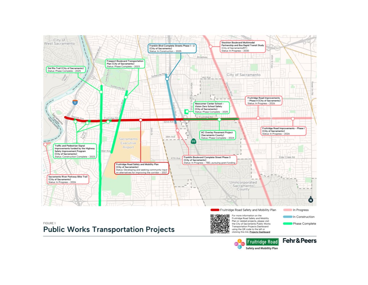
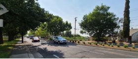
The Fruitridge Road Safety and Mobility Plan is a transportation planning effort by the City of Sacramento to reimagine this important corridor from Riverside Boulevard in the west, where it is named Seamus Avenue, to Stockton Boulevard to the east. Fruitridge Road serves a diversity of neighborhoods, schools, churches, cultural centers, and small businesses. Several important multimodal connections exist along the project including the recently completed Del Rio Trail and transit access including SacRT’s Blue Line and bus routes 61, 205, and 252.
This stretch of roadway, however, is on the City’s Vision Zero High Injury Network, which identifies corridors within the City that have the highest number of fatalities and severe-injury crashes involving people walking, biking, and driving. Fruitridge Road has also been identified as a high-priority project by the City’s Transportation Priorities Plan.
The map below provides a high-level overview of the City’s ongoing and completed transportation projects as they relate to the Fruitridge Road Safety and Mobility Plan. To learn more about each related project, you can follow this link to access the City’s Transportation Projects Dashboard.
 open_in_full
The Fruitridge Road Safety and Mobility Plan will:
- Facilitate a community-guided vision for the corridor to support all ages and abilities
- Improve access to schools, parks, businesses, and transit
- Support vibrant local businesses and cultural spaces
- Develop design options and planning-level cost estimates
- Create a toolkit for funding, implementation, and future community partnerships
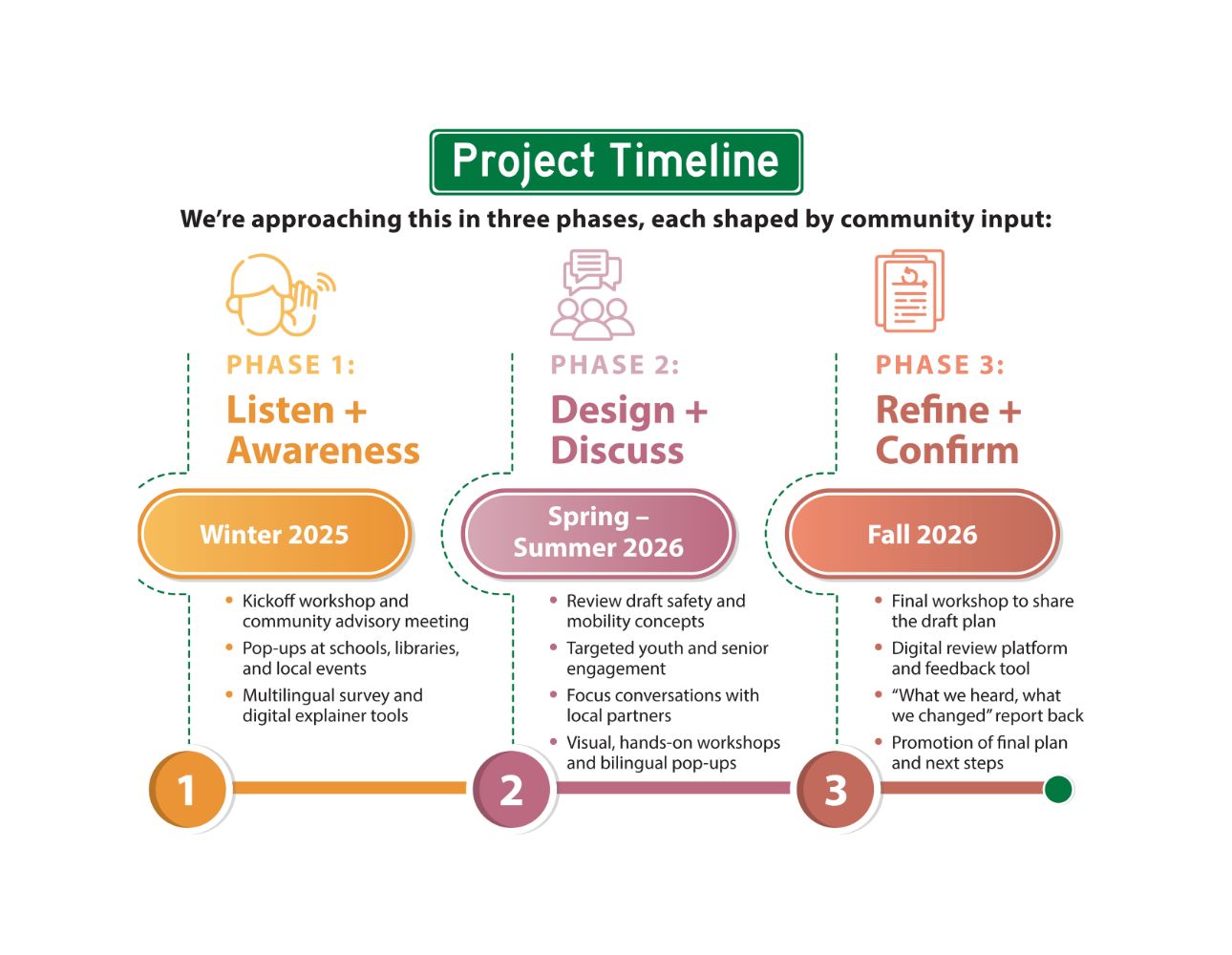
Project Timeline
We’re approaching this in three phases, each shaped by community input:
 open_in_full
How to Get Involved
This plan is shaped by the lived experiences of the communities who use Fruitridge Road. Engagement efforts are rooted in partnership with local schools, small businesses, community-based organizations, and neighborhood groups, ensuring that the outcomes truly reflect the people most impacted. Whether you live nearby, run a local business, walk your kids to school, or ride Route 61—your experience matters. We’ll be hosting workshops, pop-ups, and digital tools to make sharing your ideas easy and accessible.
Sign up for the project newsletter to learn more and stay up to date on upcoming events.
Project Documents
Coming soon!
Project Contact
Jeff Jelsma
Transportation Planner
City of Sacramento, Department of Public Works Mobility & Sustainability Division
Email: JJelsma@cityofsacramento.org
Resources
Fruitridge Road Improvements Project
Transportation Priorities Plan
Streets for People: Sacramento Active Transportation Plan
ON THIS PAGE