- City Departments
-
-
Community Development
-
Community Response
-
Convention and Cultural Services
-
Finance
-
Fire Department
-
Human Resources
-
Information Technology
-
Mayor and Council
-
Office of Public Safety Accountability
-
Office of the City Attorney
-
Office of the City Auditor
-
Office of the City Clerk
-
Office of the City Manager
-
Office of the City Treasurer
-
Police Department
-
Public Works
-
Utilities
-
Youth, Parks, & Community Enrichment
-
- Browse by categories
-
-
hiking Activities
-
pets Animals & Pets
-
domain_add Building & Planning
-
store Business
-
account_tree City Administration
-
category City Assets & Data
-
explore City Regions
-
diversity_4 Community Support
-
theater_comedy Culture & History
-
business_center Employment
-
directions Infrastructure
-
gavel Law, Code & Compliance
-
payments Money
-
park Outdoors & Sustainability
-
local_police Safety
-
directions_car Transportation
-
delete_sweep Utility Services
-
Use the menus above to navigate by City Departments or Categories.
- Convention and Cultural Services
- Arts and Culture
- Convention and Cultural Services
- Convention and Cultural Services
- Convention and Cultural Services
- Convention and Cultural Services
- Home
- Entertainment Services Division
- Arts and Culture
- Arts and Culture
- Arts and Culture
- Mayor McCarty Memo
- Arts and Culture
- Arts and Culture
- Convention and Cultural Services
- Access Leisure
- Recreation
- Recreation
- Recreation
- Youth, Parks, & Community Enrichment
- Public Art Projects
- Community Engagement
- Community Engagement
- About YPCE
- Hart Senior Center
- Recreation
- Youth Workforce Development
- Older Adult Services
- Youth, Parks, & Community Enrichment
- Long Range
- Public Art
- Youth, Parks, & Community Enrichment
- Recreation
- Recreation
- Recreation
- Home
- Youth, Parks, & Community Enrichment
- About YPCE
- About YPCE
- Older Adult Services
- Recreation
- Home
- Parking
- Innovation and Grants
- Aquatics
- CCS Partners
- District 5 - Caity Maple
- Convention and Cultural Services
- Public Art
- Community Engagement
- Office of Public Safety Accountability
- Public Art Projects
- District 7 - Rick Jennings
- Request a Permit
- Convention and Cultural Services
- CCS Partners
- Fire Department
- About YPCE
- Recycling & Solid Waste
- River District Specific Plan
- Convention and Cultural Services
- CCS Partners
- CCS Partners
- Commercial Waste Services
- Entertainment Services Division
- Entertainment Services Division
- Home
- Recreation
- Access Leisure
- Recreation
- Recreation
- Recreation
- Specialty Parks
- Mayor McCarty Memo
- Specialty Parks
- Permits for YPCE
- Recreation
- Youth, Parks, & Community Enrichment
- About YPCE
- Youth, Parks, & Community Enrichment
- Aquatics
- Recreation
- Home
- Animal Care
- Animal Care
- Community Development
- Animal Care
- Animal Care
- Animal Care
- Animal Care
- Animal Care
- Animal Care
- Specialty Parks
- Animal Care
- Animal Care
- Street Landscape Maintenance
- Accessory Dwelling Units
- City Government
- Community Development
- Building
- Contact CDD
- Building
- Building
- Building
- Building
- Business Waste Requirements
- Commercial Waste Services
- Maintenance Services
- Procurement Services Division
- Parks
- Utilities
- Public Works
- Engineering
- Fire Prevention
- Building
- Building
- Building
- Building
- Engineering
- Home
- Public Works
- Housing
- Engineering
- Housing
- Planning
- Fire Prevention
- Contact CDD
- Building
- Recycling & Solid Waste
- Fire Prevention
- Fire Prevention
- Community Development
- Community Development
- Building Programs
- Community Development
- Transportation
- Locate & Grow in Sacramento
- Planning
- Permit Services
- Planning
- Planning
- Climate Action Initiatives
- Planning
- Planning
- Parks
- Community Development
- Community Development
- Planning
- List of City Manager's Office Projects and Programs
- Public Works
- Planning
- Planning
- Public Works
- Transportation
- Planning
- Planning
- Engineering
- 102-Acre Site
- Major Planning Projects
- Community Development Meetings and Hearings
- Locate & Grow in Sacramento
- Major Planning Projects
- Planning
- City Government
- Innovation and Economic Development
- Code Compliance
- Revenue Division
- Revenue Division
- Innovation and Economic Development
- Office of the City Manager
- Recycling & Solid Waste
- Entertainment Services Division
- Business
- Business
- Procurement Services Division
- Mayor McCarty Memo
- Revenue Division
- Business
- Major Planning Projects
- City Auditor Reports
- City Auditor Reports
- Cannabis Management
- Cannabis Management
- Cannabis Management
- Business Operations Tax
- Cannabis Management
- Office of the City Manager
- Cannabis Management
- City Auditor Reports
- Cannabis Management
- Major Planning Projects
- Parking
- COVID-19 Programs
- Transportation Projects
- Innovation and Economic Development
- Innovation and Economic Development
- Business
- Public Art
- Community Engagement
- Innovation and Economic Development
- Innovation and Economic Development
- Innovation and Economic Development
- Innovation and Economic Development
- Office of the City Manager
- Business
- Business
- Innovation and Economic Development
- Innovation and Economic Development
- Mayor McCarty Memo
- Business
- Innovation and Economic Development
- Information Technology
- Public Art
- Office of the City Manager
- Business
- Finance
- Accounting Division
- Police Services
- Procurement Services Division
- City Government
- Public Art
- Code Compliance Programs
- Code Compliance Programs
- Commercial Waste Services
- Procurement Services Division
- Procurement Services Division
- Home
- Commercial Waste Services
- Procurement Services Division
- Finance
- Finance
- Procurement Services Division
- Procurement Services Division
- Office of the City Auditor
- Police Transparency
- Office of the City Auditor
- Office of the City Auditor
- Accounting Division
- Office of the City Clerk
- Home
- About YPCE
- Arts and Culture
- SVS Projects - Current, Past, and Future
- Diversity and Equity
- Records Management
- Office of the City Auditor
- Director Hearings
- Director Hearings
- Director Hearings
- Director Hearings
- District 1 - Lisa Kaplan
- District 2 - Roger Dickinson
- City Auditor Reports
- Office of the City Clerk
- About YPCE
- Police Transparency
- Home
- Records Management
- Office of the City Manager
- Office of the City Manager
- Neighborhood Directory
- Neighborhood Directory
- Community Engagement
- Public Art
- Office of the City Manager
- Innovation and Grants
- Office of the City Manager
- Office of the City Manager
- Office of the City Manager
- Home
- River District Specific Plan
- Public Art
- City Government
- Engineering
- City Government
- Long Range
- City Government
- City Government
- City Government
- City Government
- Information Technology
- Camp Sacramento
- Public Art
- Parking
- About YPCE
- Finance
- Drinking Water Quality
- Utilities
- Permit Services
- Office of Public Safety Accountability
- Pay Your Utility Bill
- Police Services
- Police Services
- Marina
- Police Services
- Contact Us
- Police Services
- Office of the City Clerk
- Home
- Public Art
- Mayor and Council
- Mayor and Council
- Mayor and Council
- Mayor and Council
- Mayor and Council
- Mayor and Council
- Mayor and Council
- Mayor and Council
- Mayor and Council
- Office of the City Clerk
- Mayor and Council
- Home
- Diversity and Equity
- Office of the City Auditor
- Office of Public Safety Accountability
- About the City Attorney's Office
- Office of the City Auditor
- Office of the City Auditor
- Police Department
- Maps and Geographic Information Systems
- Office of Public Safety Accountability
- Police Department
- City Government
- Office of the City Auditor
- Sacramento for All: Housing Education Resource Center
- 102-Acre Site
- 102-Acre Site
- 102-Acre Site
- Public Art
- Public Works
- Construction & Demolition Recycling
- About SPD
- Facilities & Real Property Management
- Public Works
- Adult Sports Activities and Resources
- Climate Action Initiatives
- Fleet Services
- Public Works
- Director Hearings
- Director Hearings
- Director Hearings
- Director Hearings
- Director Hearings
- Director Hearings
- General Plans
- Police Transparency
- Convention and Cultural Services
- Public Art
- Legislative Management
- District 1 - Lisa Kaplan
- Home
- Maps and Geographic Information Systems
- Public Art
- Office of the City Clerk
- Police Services
- Office of the City Auditor
- Office of Public Safety Accountability
- About the City Attorney's Office
- Office of the City Auditor
- Office of the City Auditor
- Police Department
- Maps and Geographic Information Systems
- Office of Public Safety Accountability
- Police Department
- City Government
- Office of the City Auditor
- Public Art Projects
- Public Art
- Public Art Projects
- Mayor and Council
- Mayor and Council
- Mayor and Council
- Mayor and Council
- Mayor and Council
- Mayor and Council
- Mayor and Council
- Mayor and Council
- Maps and Geographic Information Systems
- City Elections
- Public Art Projects
- Major Planning Projects
- Public Art
- Public Art Projects
- Police News
- Community Resources and Financial Empowerment
- Community Engagement
- Youth Workforce Development
- Locate & Grow in Sacramento
- Public Art
- Current Transportation Efforts, Plans and Programs
- Major Planning Projects
- Public Art Projects
- Engineering
- 102-Acre Site
- Major Planning Projects
- Community Development Meetings and Hearings
- Locate & Grow in Sacramento
- Major Planning Projects
- Planning
- Youth, Parks, & Community Enrichment
- Specialty Parks
- Long Range
- Public Art
- City Government
- Parking
- Transportation Projects
- About YPCE
- Home
- Engineering Programs & Services
- Current Transportation Efforts, Plans and Programs
- About OAC
- SVS Projects - Current, Past, and Future
- Youth, Parks, & Community Enrichment
- Maintenance Services
- City Government
- Older Adult Services
- Housing
- Home
- Youth, Parks, & Community Enrichment
- About YPCE
- About YPCE
- Older Adult Services
- Recreation
- Home
- 102-Acre Site
- Sacramento for All: Housing Education Resource Center
- Long Range
- City Auditor Reports
- Public Art Projects
- Central City Specific Plan
- Public Art
- Priority Projects/Investments
- Community Engagement
- Innovation and Economic Development
- Office of Public Safety Accountability
- Diversity and Equity
- Join Sacramento Fire
- Innovation and Economic Development
- Public Art Projects
- Transportation
- Responding to Homelessness
- Fire Department
- Measure U
- Office of the City Manager
- Police News
- Safety and Crime Prevention Tips
- Youth Workforce Development
- Police Department
- Community Development Meetings and Hearings
- River District Specific Plan
- Diversity and Equity
- Youth Civic Engagement
- Older Adult Services
- Vision Zero: Transportation Safety
- About Access Leisure
- Access Leisure Sports
- Access Leisure Sports
- Cannabis Management
- Office of the City Auditor
- Office of the City Auditor
- Public Art
- Public Art Projects
- Human Resources
- Financial Empowerment
- Home
- Innovation and Economic Development
- Police Community Programs
- Community Response
- Mayor McCarty Memo
- Community Response
- Workforce Development
- Police Community Programs
- Community Response
- Mayor McCarty Memo
- Community Response
- Housing
- Office of the City Manager
- Planning
- Housing
- Mayor McCarty Memo
- Housing Development Toolkit
- Permit Services
- City and County Partnership
- Housing Development Toolkit
- Housing
- Housing
- Housing
- City and County Partnership
- Code Compliance
- Housing
- Revenue Division
- Priority Projects/Investments
- Housing
- Long Range
- District 1 - Lisa Kaplan
- About YPCE
- Older Adult Services
- Recreation
- Older Adult Services
- Youth, Parks, & Community Enrichment
- Youth, Parks, & Community Enrichment
- Older Adult Services
- Housing
- Home
- About the Office of the City Auditor
- Join Sacramento Fire
- Animal Care
- District 7 Resources
- District 1 - Lisa Kaplan
- Community Engagement
- Police Community Programs
- About YPCE
- Police Department
- Youth, Parks, & Community Enrichment
- Specialty Parks
- Aquatics Programs
- Funding and Grants for Arts and Culture
- District 7 Resources
- Youth, Parks, & Community Enrichment
- CCS Partners
- Join Sacramento Fire
- About YPCE
- Aquatics Programs
- Recreation
- Aquatics
- City Auditor Reports
- Police Community Programs
- Youth, Parks, & Community Enrichment
- Public Art Projects
- Youth, Parks, & Community Enrichment
- Police Community Programs
- Youth, Parks, & Community Enrichment
- Youth, Parks, & Community Enrichment
- Recreation
- Recreation
- Youth, Parks, & Community Enrichment
- Home
- Convention and Cultural Services
- Arts and Culture
- Convention and Cultural Services
- Convention and Cultural Services
- Convention and Cultural Services
- Convention and Cultural Services
- Home
- Entertainment Services Division
- Arts and Culture
- Arts and Culture
- Arts and Culture
- Mayor McCarty Memo
- Arts and Culture
- Arts and Culture
- Convention and Cultural Services
- Parking
- Innovation and Grants
- Aquatics
- CCS Partners
- District 5 - Caity Maple
- Convention and Cultural Services
- Public Art
- Community Engagement
- Office of Public Safety Accountability
- Public Art Projects
- District 7 - Rick Jennings
- Request a Permit
- Convention and Cultural Services
- CCS Partners
- Fire Department
- About YPCE
- Recycling & Solid Waste
- River District Specific Plan
- Convention and Cultural Services
- CCS Partners
- CCS Partners
- Commercial Waste Services
- Entertainment Services Division
- Entertainment Services Division
- Home
- Sacramento for All: Housing Education Resource Center
- Sacramento for All: Housing Education Resource Center
- Public Art Projects
- Convention and Cultural Services
- About the City Attorney's Office
- Specialty Parks
- Planning
- Public Art
- Public Art Projects
- About Sacramento Fire
- CCS Partners
- Public Works
- Police Department
- About Access Leisure
- Access Leisure Sports
- Access Leisure Sports
- Cannabis Management
- Office of the City Auditor
- Office of the City Auditor
- Public Art
- Public Art Projects
- Human Resources
- Financial Empowerment
- Home
- Innovation and Economic Development
- Police Community Programs
- Human Resources
- Human Resources
- Human Resources
- Human Resources
- Home
- Human Resources
- Payroll Division
- Camp Sacramento
- HR Documents & Resources
- Human Resources
- Human Resources
- Home
- District 7 Resources
- Fire Department
- Leisure Enrichment
- Employee & Retiree Benefits
- Youth Workforce Development
- Sacramento START
- Police Services
- About the Office of the City Auditor
- Join Sacramento Fire
- Animal Care
- District 7 Resources
- District 1 - Lisa Kaplan
- Community Engagement
- Police Community Programs
- About YPCE
- Police Department
- Funding and Grants for Arts and Culture
- Youth Workforce Development
- Innovation and Economic Development
- Transportation Projects
- Transportation Projects
- Transportation Projects
- Transportation Projects
- Current Transportation Efforts, Plans and Programs
- Utilities
- Utilities
- Utilities
- Utilities
- Utilities
- Utilities
- Utilities
- Home
- Utilities
- Information Technology
- Information Technology
- Information Technology
- Information Technology
- City Government
- Information Technology
- Information Technology
- Information Technology
- Information Technology
- Home
- Fire Operations
- Information Technology
- Information Technology
- Collection Calendar
- City Government
- Information Technology
- Infrastructure Finance Division
- Home
- Infrastructure Finance Division
- Finance
- Infrastructure Finance Division
- Infrastructure Finance Division
- Building Programs
- Utilities
- Utilities
- Fire Department
- Utilities
- Utilities
- Utilities
- Utilities
- Utilities
- Utilities
- Home
- Safety Tips
- Construction Coordination
- Transportation
- Public Art
- Public Art Projects
- Transportation
- Utilities
- Public Works
- Maintenance Services
- Public Works
- Police Community Programs
- Public Art
- Home
- Survey Services
- Maintenance Services
- Maintenance Services
- Maintenance Services
- Maintenance Services
- Collection Services
- Tree Permits and Ordinances
- Public Works
- Transportation
- Transportation
- Engineering
- Transportation
- Transportation
- Park Planning & Development
- Public Art Projects
- Parks
- Public Works
- Transportation Projects
- Parks
- Public Art
- Transportation Projects
- Transportation Projects
- Transportation Projects
- Utilities
- Utilities
- Utilities
- Stormwater Quality
- Utilities
- Utilities
- Utilities
- Stormwater Quality
- Home
- Community Development
- Community Development
- Code Compliance
- Public Art
- Code Compliance
- Community Development
- Code Compliance
- Code Compliance
- Community Development
- Entertainment Services Division
- Fire Prevention
- Construction & Demolition Recycling
- Code Compliance
- Recycling & Solid Waste
- Code Compliance
- Franchise Waste Haulers
- Residential Permit Parking (RPP)
- Code Compliance
- Fire Prevention
- Contact CDD
- Building
- Recycling & Solid Waste
- Fire Prevention
- Fire Prevention
- Commercial Waste Services
- Cannabis Management
- City Government
- Recycling & Solid Waste
- Commercial Waste Services
- Disabled Person Parking
- Electric Vehicle Parking
- Fire Code Enforcement
- Police Transparency
- Commercial Waste Services
- Contact Parking Services
- Residential Permit Parking (RPP)
- Community Development
- Request a Permit
- Request a Permit
- Fire Prevention
- Contact CDD
- Public Records
- Code Compliance
- Revenue Division
- Cannabis Management
- Request a Permit
- Request a Permit
- Public Art
- Engineering
- Request a Permit
- Entertainment Services Division
- Convention and Cultural Services
- Housing Development Incentives
- Entertainment Services Division
- Housing Development Incentives
- Public Works
- Public Works
- Building
- Youth, Parks, & Community Enrichment
- Locate & Grow in Sacramento
- Building
- Request a Permit
- Public Works
- Revenue Division
- Commercial Waste Services
- Entertainment Services Division
- Building Programs
- Mayor McCarty Memo
- Urban Forestry
- Planning
- Finance
- Accounting Division
- Home
- Accounting Division
- City Auditor Reports
- Collection Services
- Payroll Division
- Mayor McCarty Memo
- Office of the City Manager
- Finance
- Budget Division
- Budget Division
- Home
- Measure U
- Mayor McCarty Memo
- Access Leisure
- Climate and Sustainability Planning
- Pay Your Utility Bill
- Hart Senior Center
- Recycling & Solid Waste
- Discount Deals
- Water Conservation
- Youth, Parks, & Community Enrichment
- Aquatics
- Finance
- Utility User Tax
- Recreation
- Office of the City Treasurer
- Office of the City Treasurer
- Office of the City Treasurer
- Home
- Office of the City Treasurer
- Parking
- COVID-19 Programs
- Transportation Projects
- Innovation and Economic Development
- Innovation and Economic Development
- Business
- Public Art
- Community Engagement
- Innovation and Economic Development
- Innovation and Economic Development
- Innovation and Economic Development
- Innovation and Economic Development
- Office of the City Manager
- Business
- Business
- Innovation and Economic Development
- Innovation and Economic Development
- Mayor McCarty Memo
- Business
- Innovation and Economic Development
- CORE
- Convention and Cultural Services
- Stormwater Quality
- Funding and Grants for Arts and Culture
- Funding and Grants for Arts and Culture
- Funding and Grants for Arts and Culture
- Economic Gardening
- Entertainment Services Division
- Forward Together Pilot Grant for North Sacramento
- Innovation and Grants
- Recycling & Solid Waste
- Innovation and Grants
- Innovation and Grants
- About OAC
- Engineering
- Youth, Parks, & Community Enrichment
- Infrastructure Finance Division
- Home
- Infrastructure Finance Division
- Finance
- Infrastructure Finance Division
- Infrastructure Finance Division
- Building Programs
- Office of the City Treasurer
- Office of the City Treasurer
- Home
- Office of the City Treasurer
- Building
- Revenue Division
- Cannabis Business Operating Permits
- Recycling & Solid Waste
- Revenue Division
- Development Standards
- Development Standards
- Emergency Medical Services
- Finance
- Community Engagement
- Marina
- Household Hazardous Waste
- Public Works
- Community Development
- Utilities
- City Government
- Finance
- Animal Care
- Home
- Revenue Division
- Development Standards
- Marina
- Permits for YPCE
- Revenue Division
- Infrastructure Finance Division
- Home
- Workforce Development
- List of City Manager's Office Projects and Programs
- About YPCE
- Revenue Division
- Budget Division
- Revenue Division
- Revenue Division
- Transportation
- Current Transportation Efforts, Plans and Programs
- Public Art Projects
- Transportation Projects
- Climate Action Initiatives
- Housing
- Public Art
- Current Transportation Efforts, Plans and Programs
- Public Works
- Current Transportation Efforts, Plans and Programs
- Current Transportation Efforts, Plans and Programs
- Current Transportation Efforts, Plans and Programs
- Current Transportation Efforts, Plans and Programs
- Public Works
- Home
- Access Leisure
- Recreation
- Recreation
- Recreation
- Street Landscape Maintenance
- Public Art
- Climate Action and Sustainability
- Climate Action and Sustainability
- Public Works
- Climate Action and Sustainability
- Climate and Sustainability Planning
- Public Art Projects
- Planning
- Fleet Services
- Climate Action and Sustainability
- Procurement Services Division
- Business Waste Requirements
- Permit Services
- Utilities
- Climate Action and Sustainability
- Utilities
- Recreation
- Public Art Projects
- Public Art
- About YPCE
- Public Works
- Youth, Parks, & Community Enrichment
- About YPCE
- Public Art
- Public Art Projects
- Commercial Waste Services
- Permits for YPCE
- About YPCE
- Home
- Current Transportation Efforts, Plans and Programs
- Recreation
- Access Leisure
- Recreation
- Recreation
- Recreation
- Specialty Parks
- Mayor McCarty Memo
- Specialty Parks
- Permits for YPCE
- Recreation
- Youth, Parks, & Community Enrichment
- About YPCE
- Youth, Parks, & Community Enrichment
- Aquatics
- Recreation
- Home
- Park Planning & Development
- Public Art Projects
- Parks
- Public Works
- Transportation Projects
- Parks
- Public Art
- Transportation Projects
- Transportation Projects
- Transportation Projects
- Urban Forestry
- Parks
- Public Works
- Parks
- Home
- Urban Forestry
- Urban Forestry
- Urban Forestry
- Climate Action Initiatives
- Maintenance Services
- Safety Tips
- Fire Department
- Specialty Parks
- Community Response
- Community Response
- Home
- Office of the City Manager
- Contact Us
- Contact Us
- Crime and Safety
- Crime and Safety
- Crime and Safety
- Crime and Safety
- Crime and Safety
- Police Services
- Fire Prevention
- Crime and Safety
- Police Services
- Crime and Safety
- Pay Your Utility Bill
- Crime and Safety
- Office of the City Auditor
- City Auditor Reports
- Fire Prevention
- Fire Department
- Fire Department
- Crime and Safety
- Join Sacramento Fire
- Join Sacramento Fire
- Emergency Management
- Fire Department
- Fire Department
- Fire Department
- Fire Department
- Home
- Fire Department
- Fire Department
- Fire Department
- Home
- Fire Department
- Fire Prevention
- Contact CDD
- Building
- Recycling & Solid Waste
- Fire Prevention
- Fire Prevention
- Request a Permit
- Request a Permit
- Police Services
- Police Services
- Request a Permit
- Request a Permit
- Police Services
- Police Department
- Request a Permit
- Police Services
- Police Services
- Police Services
- Police Services
- Public Information Office
- Police Services
- Home
- Police Department
- Home
- Police Department
- Police Department
- Request a Permit
- Police Services
- Police Services
- Police Services
- Police Services
- Police Services
- Police Services
- Police Department
- Emergency Management
- Police Department
- Information Technology
- Flood Preparedness
- Fire Department
- District 1 - Lisa Kaplan
- Utilities
- Utilities
- Fire Department
- Utilities
- Utilities
- Utilities
- Utilities
- Utilities
- Utilities
- Home
- Safety Tips
- Safety Tips
- Fire Department
- Specialty Parks
- Transportation
- Current Transportation Efforts, Plans and Programs
- Public Art Projects
- Transportation Projects
- Climate Action Initiatives
- Housing
- Public Art
- Current Transportation Efforts, Plans and Programs
- Public Works
- Current Transportation Efforts, Plans and Programs
- Current Transportation Efforts, Plans and Programs
- Current Transportation Efforts, Plans and Programs
- Current Transportation Efforts, Plans and Programs
- Public Works
- Home
- Current Transportation Efforts, Plans and Programs
- Public Art Projects
- Transportation Technology
- Current Transportation Efforts, Plans and Programs
- SVS Connectivity Projects
- Current Transportation Efforts, Plans and Programs
- Parking
- Fleet Services
- Climate Action Initiatives
- Current Transportation Efforts, Plans and Programs
- Police Services
- Marina
- Marina
- Public Works
- Housing
- Home
- Public Works
- Current Transportation Efforts, Plans and Programs
- Collection Services
- Sacramento Valley Station
- Transportation Projects
- Current Transportation Efforts, Plans and Programs
- Public Art Projects
- Transportation Projects
- Current Transportation Efforts, Plans and Programs
- Public Works
- Transportation Projects
- Long Range
- Current Transportation Efforts, Plans and Programs
- Transportation Projects
- Transportation
- Public Works
- Home
- Public Works
- File a Police Report
- Public Works
- Transportation
- Transportation
- Transportation
- Transportation
- Transportation
- Public Art Projects
- Public Art Projects
- Transportation
- Public Art
- Engineering
- Transportation
- Utilities
- Utilities
- Utilities
- Utilities
- Utilities
- Utilities
- Utilities
- Home
- Utilities
- Recycling & Solid Waste
- Recycling & Solid Waste
- Recycling & Solid Waste
- Recycling & Solid Waste
- Recycling & Solid Waste
- Recycling & Solid Waste
- Recycling & Solid Waste
- Public Works
- Climate Action Initiatives
- Recycling & Solid Waste
- Recycling & Solid Waste
- Recycling & Solid Waste
- Recycling & Solid Waste
- Recycling & Solid Waste
- Recycling & Solid Waste
- Recycling & Solid Waste
- Recycling & Solid Waste
- Recycling & Solid Waste
- Public Works
- Climate Action Initiatives
- Recycling & Solid Waste
- Utilities
- Utilities
- Utilities
- Stormwater Quality
- Utilities
- Utilities
- Utilities
- Stormwater Quality
- Home
- City Departments
-
-
Community Development
-
Community Response
-
Convention and Cultural Services
-
Finance
-
Fire Department
-
Human Resources
-
Information Technology
-
Mayor and Council
-
Office of Public Safety Accountability
-
Office of the City Attorney
-
Office of the City Auditor
-
Office of the City Clerk
-
Office of the City Manager
-
Office of the City Treasurer
-
Police Department
-
Public Works
-
Utilities
-
Youth, Parks, & Community Enrichment
-
- Browse by categories
-
-
hiking Activities
-
pets Animals & Pets
-
domain_add Building & Planning
-
store Business
-
account_tree City Administration
-
category City Assets & Data
-
explore City Regions
-
diversity_4 Community Support
-
theater_comedy Culture & History
-
business_center Employment
-
directions Infrastructure
-
gavel Law, Code & Compliance
-
payments Money
-
park Outdoors & Sustainability
-
local_police Safety
-
directions_car Transportation
-
delete_sweep Utility Services
-
Use the menus above to navigate by City Departments or Categories.
You can also use the Search function below to find specific content on our site.
- Convention and Cultural Services
- Arts and Culture
- Convention and Cultural Services
- Convention and Cultural Services
- Convention and Cultural Services
- Convention and Cultural Services
- Home
- Entertainment Services Division
- Arts and Culture
- Arts and Culture
- Arts and Culture
- Mayor McCarty Memo
- Arts and Culture
- Arts and Culture
- Convention and Cultural Services
- Access Leisure
- Recreation
- Recreation
- Recreation
- Youth, Parks, & Community Enrichment
- Public Art Projects
- Community Engagement
- Community Engagement
- About YPCE
- Hart Senior Center
- Recreation
- Youth Workforce Development
- Older Adult Services
- Youth, Parks, & Community Enrichment
- Long Range
- Public Art
- Youth, Parks, & Community Enrichment
- Recreation
- Recreation
- Recreation
- Home
- Youth, Parks, & Community Enrichment
- About YPCE
- About YPCE
- Older Adult Services
- Recreation
- Home
- Parking
- Innovation and Grants
- Aquatics
- CCS Partners
- District 5 - Caity Maple
- Convention and Cultural Services
- Public Art
- Community Engagement
- Office of Public Safety Accountability
- Public Art Projects
- District 7 - Rick Jennings
- Request a Permit
- Convention and Cultural Services
- CCS Partners
- Fire Department
- About YPCE
- Recycling & Solid Waste
- River District Specific Plan
- Convention and Cultural Services
- CCS Partners
- CCS Partners
- Commercial Waste Services
- Entertainment Services Division
- Entertainment Services Division
- Home
- Recreation
- Access Leisure
- Recreation
- Recreation
- Recreation
- Specialty Parks
- Mayor McCarty Memo
- Specialty Parks
- Permits for YPCE
- Recreation
- Youth, Parks, & Community Enrichment
- About YPCE
- Youth, Parks, & Community Enrichment
- Aquatics
- Recreation
- Home
- Animal Care
- Animal Care
- Community Development
- Animal Care
- Animal Care
- Animal Care
- Animal Care
- Animal Care
- Animal Care
- Specialty Parks
- Animal Care
- Animal Care
- Street Landscape Maintenance
- Accessory Dwelling Units
- City Government
- Community Development
- Building
- Contact CDD
- Building
- Building
- Building
- Building
- Business Waste Requirements
- Commercial Waste Services
- Maintenance Services
- Procurement Services Division
- Parks
- Utilities
- Public Works
- Engineering
- Fire Prevention
- Building
- Building
- Building
- Building
- Engineering
- Home
- Public Works
- Housing
- Engineering
- Housing
- Planning
- Fire Prevention
- Contact CDD
- Building
- Recycling & Solid Waste
- Fire Prevention
- Fire Prevention
- Community Development
- Community Development
- Building Programs
- Community Development
- Transportation
- Locate & Grow in Sacramento
- Planning
- Permit Services
- Planning
- Planning
- Climate Action Initiatives
- Planning
- Planning
- Parks
- Community Development
- Community Development
- Planning
- List of City Manager's Office Projects and Programs
- Public Works
- Planning
- Planning
- Public Works
- Transportation
- Planning
- Planning
- Engineering
- 102-Acre Site
- Major Planning Projects
- Community Development Meetings and Hearings
- Locate & Grow in Sacramento
- Major Planning Projects
- Planning
- City Government
- Innovation and Economic Development
- Code Compliance
- Revenue Division
- Revenue Division
- Innovation and Economic Development
- Office of the City Manager
- Recycling & Solid Waste
- Entertainment Services Division
- Business
- Business
- Procurement Services Division
- Mayor McCarty Memo
- Revenue Division
- Business
- Major Planning Projects
- City Auditor Reports
- City Auditor Reports
- Cannabis Management
- Cannabis Management
- Cannabis Management
- Business Operations Tax
- Cannabis Management
- Office of the City Manager
- Cannabis Management
- City Auditor Reports
- Cannabis Management
- Major Planning Projects
- Parking
- COVID-19 Programs
- Transportation Projects
- Innovation and Economic Development
- Innovation and Economic Development
- Business
- Public Art
- Community Engagement
- Innovation and Economic Development
- Innovation and Economic Development
- Innovation and Economic Development
- Innovation and Economic Development
- Office of the City Manager
- Business
- Business
- Innovation and Economic Development
- Innovation and Economic Development
- Mayor McCarty Memo
- Business
- Innovation and Economic Development
- Information Technology
- Public Art
- Office of the City Manager
- Business
- Finance
- Accounting Division
- Police Services
- Procurement Services Division
- City Government
- Public Art
- Code Compliance Programs
- Code Compliance Programs
- Commercial Waste Services
- Procurement Services Division
- Procurement Services Division
- Home
- Commercial Waste Services
- Procurement Services Division
- Finance
- Finance
- Procurement Services Division
- Procurement Services Division
- Office of the City Auditor
- Police Transparency
- Office of the City Auditor
- Office of the City Auditor
- Accounting Division
- Office of the City Clerk
- Home
- About YPCE
- Arts and Culture
- SVS Projects - Current, Past, and Future
- Diversity and Equity
- Records Management
- Office of the City Auditor
- Director Hearings
- Director Hearings
- Director Hearings
- Director Hearings
- District 1 - Lisa Kaplan
- District 2 - Roger Dickinson
- City Auditor Reports
- Office of the City Clerk
- About YPCE
- Police Transparency
- Home
- Records Management
- Office of the City Manager
- Office of the City Manager
- Neighborhood Directory
- Neighborhood Directory
- Community Engagement
- Public Art
- Office of the City Manager
- Innovation and Grants
- Office of the City Manager
- Office of the City Manager
- Office of the City Manager
- Home
- River District Specific Plan
- Public Art
- City Government
- Engineering
- City Government
- Long Range
- City Government
- City Government
- City Government
- City Government
- Information Technology
- Camp Sacramento
- Public Art
- Parking
- About YPCE
- Finance
- Drinking Water Quality
- Utilities
- Permit Services
- Office of Public Safety Accountability
- Pay Your Utility Bill
- Police Services
- Police Services
- Marina
- Police Services
- Contact Us
- Police Services
- Office of the City Clerk
- Home
- Public Art
- Mayor and Council
- Mayor and Council
- Mayor and Council
- Mayor and Council
- Mayor and Council
- Mayor and Council
- Mayor and Council
- Mayor and Council
- Mayor and Council
- Office of the City Clerk
- Mayor and Council
- Home
- Diversity and Equity
- Office of the City Auditor
- Office of Public Safety Accountability
- About the City Attorney's Office
- Office of the City Auditor
- Office of the City Auditor
- Police Department
- Maps and Geographic Information Systems
- Office of Public Safety Accountability
- Police Department
- City Government
- Office of the City Auditor
- Sacramento for All: Housing Education Resource Center
- 102-Acre Site
- 102-Acre Site
- 102-Acre Site
- Public Art
- Public Works
- Construction & Demolition Recycling
- About SPD
- Facilities & Real Property Management
- Public Works
- Adult Sports Activities and Resources
- Climate Action Initiatives
- Fleet Services
- Public Works
- Director Hearings
- Director Hearings
- Director Hearings
- Director Hearings
- Director Hearings
- Director Hearings
- General Plans
- Police Transparency
- Convention and Cultural Services
- Public Art
- Legislative Management
- District 1 - Lisa Kaplan
- Home
- Maps and Geographic Information Systems
- Public Art
- Office of the City Clerk
- Police Services
- Office of the City Auditor
- Office of Public Safety Accountability
- About the City Attorney's Office
- Office of the City Auditor
- Office of the City Auditor
- Police Department
- Maps and Geographic Information Systems
- Office of Public Safety Accountability
- Police Department
- City Government
- Office of the City Auditor
- Public Art Projects
- Public Art
- Public Art Projects
- Mayor and Council
- Mayor and Council
- Mayor and Council
- Mayor and Council
- Mayor and Council
- Mayor and Council
- Mayor and Council
- Mayor and Council
- Maps and Geographic Information Systems
- City Elections
- Public Art Projects
- Major Planning Projects
- Public Art
- Public Art Projects
- Police News
- Community Resources and Financial Empowerment
- Community Engagement
- Youth Workforce Development
- Locate & Grow in Sacramento
- Public Art
- Current Transportation Efforts, Plans and Programs
- Major Planning Projects
- Public Art Projects
- Engineering
- 102-Acre Site
- Major Planning Projects
- Community Development Meetings and Hearings
- Locate & Grow in Sacramento
- Major Planning Projects
- Planning
- Youth, Parks, & Community Enrichment
- Specialty Parks
- Long Range
- Public Art
- City Government
- Parking
- Transportation Projects
- About YPCE
- Home
- Engineering Programs & Services
- Current Transportation Efforts, Plans and Programs
- About OAC
- SVS Projects - Current, Past, and Future
- Youth, Parks, & Community Enrichment
- Maintenance Services
- City Government
- Older Adult Services
- Housing
- Home
- Youth, Parks, & Community Enrichment
- About YPCE
- About YPCE
- Older Adult Services
- Recreation
- Home
- 102-Acre Site
- Sacramento for All: Housing Education Resource Center
- Long Range
- City Auditor Reports
- Public Art Projects
- Central City Specific Plan
- Public Art
- Priority Projects/Investments
- Community Engagement
- Innovation and Economic Development
- Office of Public Safety Accountability
- Diversity and Equity
- Join Sacramento Fire
- Innovation and Economic Development
- Public Art Projects
- Transportation
- Responding to Homelessness
- Fire Department
- Measure U
- Office of the City Manager
- Police News
- Safety and Crime Prevention Tips
- Youth Workforce Development
- Police Department
- Community Development Meetings and Hearings
- River District Specific Plan
- Diversity and Equity
- Youth Civic Engagement
- Older Adult Services
- Vision Zero: Transportation Safety
- About Access Leisure
- Access Leisure Sports
- Access Leisure Sports
- Cannabis Management
- Office of the City Auditor
- Office of the City Auditor
- Public Art
- Public Art Projects
- Human Resources
- Financial Empowerment
- Home
- Innovation and Economic Development
- Police Community Programs
- Community Response
- Mayor McCarty Memo
- Community Response
- Workforce Development
- Police Community Programs
- Community Response
- Mayor McCarty Memo
- Community Response
- Housing
- Office of the City Manager
- Planning
- Housing
- Mayor McCarty Memo
- Housing Development Toolkit
- Permit Services
- City and County Partnership
- Housing Development Toolkit
- Housing
- Housing
- Housing
- City and County Partnership
- Code Compliance
- Housing
- Revenue Division
- Priority Projects/Investments
- Housing
- Long Range
- District 1 - Lisa Kaplan
- About YPCE
- Older Adult Services
- Recreation
- Older Adult Services
- Youth, Parks, & Community Enrichment
- Youth, Parks, & Community Enrichment
- Older Adult Services
- Housing
- Home
- About the Office of the City Auditor
- Join Sacramento Fire
- Animal Care
- District 7 Resources
- District 1 - Lisa Kaplan
- Community Engagement
- Police Community Programs
- About YPCE
- Police Department
- Youth, Parks, & Community Enrichment
- Specialty Parks
- Aquatics Programs
- Funding and Grants for Arts and Culture
- District 7 Resources
- Youth, Parks, & Community Enrichment
- CCS Partners
- Join Sacramento Fire
- About YPCE
- Aquatics Programs
- Recreation
- Aquatics
- City Auditor Reports
- Police Community Programs
- Youth, Parks, & Community Enrichment
- Public Art Projects
- Youth, Parks, & Community Enrichment
- Police Community Programs
- Youth, Parks, & Community Enrichment
- Youth, Parks, & Community Enrichment
- Recreation
- Recreation
- Youth, Parks, & Community Enrichment
- Home
- Convention and Cultural Services
- Arts and Culture
- Convention and Cultural Services
- Convention and Cultural Services
- Convention and Cultural Services
- Convention and Cultural Services
- Home
- Entertainment Services Division
- Arts and Culture
- Arts and Culture
- Arts and Culture
- Mayor McCarty Memo
- Arts and Culture
- Arts and Culture
- Convention and Cultural Services
- Parking
- Innovation and Grants
- Aquatics
- CCS Partners
- District 5 - Caity Maple
- Convention and Cultural Services
- Public Art
- Community Engagement
- Office of Public Safety Accountability
- Public Art Projects
- District 7 - Rick Jennings
- Request a Permit
- Convention and Cultural Services
- CCS Partners
- Fire Department
- About YPCE
- Recycling & Solid Waste
- River District Specific Plan
- Convention and Cultural Services
- CCS Partners
- CCS Partners
- Commercial Waste Services
- Entertainment Services Division
- Entertainment Services Division
- Home
- Sacramento for All: Housing Education Resource Center
- Sacramento for All: Housing Education Resource Center
- Public Art Projects
- Convention and Cultural Services
- About the City Attorney's Office
- Specialty Parks
- Planning
- Public Art
- Public Art Projects
- About Sacramento Fire
- CCS Partners
- Public Works
- Police Department
- About Access Leisure
- Access Leisure Sports
- Access Leisure Sports
- Cannabis Management
- Office of the City Auditor
- Office of the City Auditor
- Public Art
- Public Art Projects
- Human Resources
- Financial Empowerment
- Home
- Innovation and Economic Development
- Police Community Programs
- Human Resources
- Human Resources
- Human Resources
- Human Resources
- Home
- Human Resources
- Payroll Division
- Camp Sacramento
- HR Documents & Resources
- Human Resources
- Human Resources
- Home
- District 7 Resources
- Fire Department
- Leisure Enrichment
- Employee & Retiree Benefits
- Youth Workforce Development
- Sacramento START
- Police Services
- About the Office of the City Auditor
- Join Sacramento Fire
- Animal Care
- District 7 Resources
- District 1 - Lisa Kaplan
- Community Engagement
- Police Community Programs
- About YPCE
- Police Department
- Funding and Grants for Arts and Culture
- Youth Workforce Development
- Innovation and Economic Development
- Transportation Projects
- Transportation Projects
- Transportation Projects
- Transportation Projects
- Current Transportation Efforts, Plans and Programs
- Utilities
- Utilities
- Utilities
- Utilities
- Utilities
- Utilities
- Utilities
- Home
- Utilities
- Information Technology
- Information Technology
- Information Technology
- Information Technology
- City Government
- Information Technology
- Information Technology
- Information Technology
- Information Technology
- Home
- Fire Operations
- Information Technology
- Information Technology
- Collection Calendar
- City Government
- Information Technology
- Infrastructure Finance Division
- Home
- Infrastructure Finance Division
- Finance
- Infrastructure Finance Division
- Infrastructure Finance Division
- Building Programs
- Utilities
- Utilities
- Fire Department
- Utilities
- Utilities
- Utilities
- Utilities
- Utilities
- Utilities
- Home
- Safety Tips
- Construction Coordination
- Transportation
- Public Art
- Public Art Projects
- Transportation
- Utilities
- Public Works
- Maintenance Services
- Public Works
- Police Community Programs
- Public Art
- Home
- Survey Services
- Maintenance Services
- Maintenance Services
- Maintenance Services
- Maintenance Services
- Collection Services
- Tree Permits and Ordinances
- Public Works
- Transportation
- Transportation
- Engineering
- Transportation
- Transportation
- Park Planning & Development
- Public Art Projects
- Parks
- Public Works
- Transportation Projects
- Parks
- Public Art
- Transportation Projects
- Transportation Projects
- Transportation Projects
- Utilities
- Utilities
- Utilities
- Stormwater Quality
- Utilities
- Utilities
- Utilities
- Stormwater Quality
- Home
- Community Development
- Community Development
- Code Compliance
- Public Art
- Code Compliance
- Community Development
- Code Compliance
- Code Compliance
- Community Development
- Entertainment Services Division
- Fire Prevention
- Construction & Demolition Recycling
- Code Compliance
- Recycling & Solid Waste
- Code Compliance
- Franchise Waste Haulers
- Residential Permit Parking (RPP)
- Code Compliance
- Fire Prevention
- Contact CDD
- Building
- Recycling & Solid Waste
- Fire Prevention
- Fire Prevention
- Commercial Waste Services
- Cannabis Management
- City Government
- Recycling & Solid Waste
- Commercial Waste Services
- Disabled Person Parking
- Electric Vehicle Parking
- Fire Code Enforcement
- Police Transparency
- Commercial Waste Services
- Contact Parking Services
- Residential Permit Parking (RPP)
- Community Development
- Request a Permit
- Request a Permit
- Fire Prevention
- Contact CDD
- Public Records
- Code Compliance
- Revenue Division
- Cannabis Management
- Request a Permit
- Request a Permit
- Public Art
- Engineering
- Request a Permit
- Entertainment Services Division
- Convention and Cultural Services
- Housing Development Incentives
- Entertainment Services Division
- Housing Development Incentives
- Public Works
- Public Works
- Building
- Youth, Parks, & Community Enrichment
- Locate & Grow in Sacramento
- Building
- Request a Permit
- Public Works
- Revenue Division
- Commercial Waste Services
- Entertainment Services Division
- Building Programs
- Mayor McCarty Memo
- Urban Forestry
- Planning
- Finance
- Accounting Division
- Home
- Accounting Division
- City Auditor Reports
- Collection Services
- Payroll Division
- Mayor McCarty Memo
- Office of the City Manager
- Finance
- Budget Division
- Budget Division
- Home
- Measure U
- Mayor McCarty Memo
- Access Leisure
- Climate and Sustainability Planning
- Pay Your Utility Bill
- Hart Senior Center
- Recycling & Solid Waste
- Discount Deals
- Water Conservation
- Youth, Parks, & Community Enrichment
- Aquatics
- Finance
- Utility User Tax
- Recreation
- Office of the City Treasurer
- Office of the City Treasurer
- Office of the City Treasurer
- Home
- Office of the City Treasurer
- Parking
- COVID-19 Programs
- Transportation Projects
- Innovation and Economic Development
- Innovation and Economic Development
- Business
- Public Art
- Community Engagement
- Innovation and Economic Development
- Innovation and Economic Development
- Innovation and Economic Development
- Innovation and Economic Development
- Office of the City Manager
- Business
- Business
- Innovation and Economic Development
- Innovation and Economic Development
- Mayor McCarty Memo
- Business
- Innovation and Economic Development
- CORE
- Convention and Cultural Services
- Stormwater Quality
- Funding and Grants for Arts and Culture
- Funding and Grants for Arts and Culture
- Funding and Grants for Arts and Culture
- Economic Gardening
- Entertainment Services Division
- Forward Together Pilot Grant for North Sacramento
- Innovation and Grants
- Recycling & Solid Waste
- Innovation and Grants
- Innovation and Grants
- About OAC
- Engineering
- Youth, Parks, & Community Enrichment
- Infrastructure Finance Division
- Home
- Infrastructure Finance Division
- Finance
- Infrastructure Finance Division
- Infrastructure Finance Division
- Building Programs
- Office of the City Treasurer
- Office of the City Treasurer
- Home
- Office of the City Treasurer
- Building
- Revenue Division
- Cannabis Business Operating Permits
- Recycling & Solid Waste
- Revenue Division
- Development Standards
- Development Standards
- Emergency Medical Services
- Finance
- Community Engagement
- Marina
- Household Hazardous Waste
- Public Works
- Community Development
- Utilities
- City Government
- Finance
- Animal Care
- Home
- Revenue Division
- Development Standards
- Marina
- Permits for YPCE
- Revenue Division
- Infrastructure Finance Division
- Home
- Workforce Development
- List of City Manager's Office Projects and Programs
- About YPCE
- Revenue Division
- Budget Division
- Revenue Division
- Revenue Division
- Transportation
- Current Transportation Efforts, Plans and Programs
- Public Art Projects
- Transportation Projects
- Climate Action Initiatives
- Housing
- Public Art
- Current Transportation Efforts, Plans and Programs
- Public Works
- Current Transportation Efforts, Plans and Programs
- Current Transportation Efforts, Plans and Programs
- Current Transportation Efforts, Plans and Programs
- Current Transportation Efforts, Plans and Programs
- Public Works
- Home
- Access Leisure
- Recreation
- Recreation
- Recreation
- Street Landscape Maintenance
- Public Art
- Climate Action and Sustainability
- Climate Action and Sustainability
- Public Works
- Climate Action and Sustainability
- Climate and Sustainability Planning
- Public Art Projects
- Planning
- Fleet Services
- Climate Action and Sustainability
- Procurement Services Division
- Business Waste Requirements
- Permit Services
- Utilities
- Climate Action and Sustainability
- Utilities
- Recreation
- Public Art Projects
- Public Art
- About YPCE
- Public Works
- Youth, Parks, & Community Enrichment
- About YPCE
- Public Art
- Public Art Projects
- Commercial Waste Services
- Permits for YPCE
- About YPCE
- Home
- Current Transportation Efforts, Plans and Programs
- Recreation
- Access Leisure
- Recreation
- Recreation
- Recreation
- Specialty Parks
- Mayor McCarty Memo
- Specialty Parks
- Permits for YPCE
- Recreation
- Youth, Parks, & Community Enrichment
- About YPCE
- Youth, Parks, & Community Enrichment
- Aquatics
- Recreation
- Home
- Park Planning & Development
- Public Art Projects
- Parks
- Public Works
- Transportation Projects
- Parks
- Public Art
- Transportation Projects
- Transportation Projects
- Transportation Projects
- Urban Forestry
- Parks
- Public Works
- Parks
- Home
- Urban Forestry
- Urban Forestry
- Urban Forestry
- Climate Action Initiatives
- Maintenance Services
- Safety Tips
- Fire Department
- Specialty Parks
- Community Response
- Community Response
- Home
- Office of the City Manager
- Contact Us
- Contact Us
- Crime and Safety
- Crime and Safety
- Crime and Safety
- Crime and Safety
- Crime and Safety
- Police Services
- Fire Prevention
- Crime and Safety
- Police Services
- Crime and Safety
- Pay Your Utility Bill
- Crime and Safety
- Office of the City Auditor
- City Auditor Reports
- Fire Prevention
- Fire Department
- Fire Department
- Crime and Safety
- Join Sacramento Fire
- Join Sacramento Fire
- Emergency Management
- Fire Department
- Fire Department
- Fire Department
- Fire Department
- Home
- Fire Department
- Fire Department
- Fire Department
- Home
- Fire Department
- Fire Prevention
- Contact CDD
- Building
- Recycling & Solid Waste
- Fire Prevention
- Fire Prevention
- Request a Permit
- Request a Permit
- Police Services
- Police Services
- Request a Permit
- Request a Permit
- Police Services
- Police Department
- Request a Permit
- Police Services
- Police Services
- Police Services
- Police Services
- Public Information Office
- Police Services
- Home
- Police Department
- Home
- Police Department
- Police Department
- Request a Permit
- Police Services
- Police Services
- Police Services
- Police Services
- Police Services
- Police Services
- Police Department
- Emergency Management
- Police Department
- Information Technology
- Flood Preparedness
- Fire Department
- District 1 - Lisa Kaplan
- Utilities
- Utilities
- Fire Department
- Utilities
- Utilities
- Utilities
- Utilities
- Utilities
- Utilities
- Home
- Safety Tips
- Safety Tips
- Fire Department
- Specialty Parks
- Transportation
- Current Transportation Efforts, Plans and Programs
- Public Art Projects
- Transportation Projects
- Climate Action Initiatives
- Housing
- Public Art
- Current Transportation Efforts, Plans and Programs
- Public Works
- Current Transportation Efforts, Plans and Programs
- Current Transportation Efforts, Plans and Programs
- Current Transportation Efforts, Plans and Programs
- Current Transportation Efforts, Plans and Programs
- Public Works
- Home
- Current Transportation Efforts, Plans and Programs
- Public Art Projects
- Transportation Technology
- Current Transportation Efforts, Plans and Programs
- SVS Connectivity Projects
- Current Transportation Efforts, Plans and Programs
- Parking
- Fleet Services
- Climate Action Initiatives
- Current Transportation Efforts, Plans and Programs
- Police Services
- Marina
- Marina
- Public Works
- Housing
- Home
- Public Works
- Current Transportation Efforts, Plans and Programs
- Collection Services
- Sacramento Valley Station
- Transportation Projects
- Current Transportation Efforts, Plans and Programs
- Public Art Projects
- Transportation Projects
- Current Transportation Efforts, Plans and Programs
- Public Works
- Transportation Projects
- Long Range
- Current Transportation Efforts, Plans and Programs
- Transportation Projects
- Transportation
- Public Works
- Home
- Public Works
- File a Police Report
- Public Works
- Transportation
- Transportation
- Transportation
- Transportation
- Transportation
- Public Art Projects
- Public Art Projects
- Transportation
- Public Art
- Engineering
- Transportation
- Utilities
- Utilities
- Utilities
- Utilities
- Utilities
- Utilities
- Utilities
- Home
- Utilities
- Recycling & Solid Waste
- Recycling & Solid Waste
- Recycling & Solid Waste
- Recycling & Solid Waste
- Recycling & Solid Waste
- Recycling & Solid Waste
- Recycling & Solid Waste
- Public Works
- Climate Action Initiatives
- Recycling & Solid Waste
- Recycling & Solid Waste
- Recycling & Solid Waste
- Recycling & Solid Waste
- Recycling & Solid Waste
- Recycling & Solid Waste
- Recycling & Solid Waste
- Recycling & Solid Waste
- Recycling & Solid Waste
- Public Works
- Climate Action Initiatives
- Recycling & Solid Waste
- Utilities
- Utilities
- Utilities
- Stormwater Quality
- Utilities
- Utilities
- Utilities
- Stormwater Quality
- Home
Search for content
SITE NAVIGATION
- Connecting Howe Avenue
- Dixieanne Neighborhood
- Reconnecting Old North Sacramento
- Shared Mobility
- Street Design Standards Amendment
- Streets for People: Sacramento Active Transportation Plan
- The Norwood Mobility Project
- Transportation Demand Management
- Transportation Priorities Plan
- Work Zone and Event Detours
Truxel Bridge
 open_in_full
Project Overview
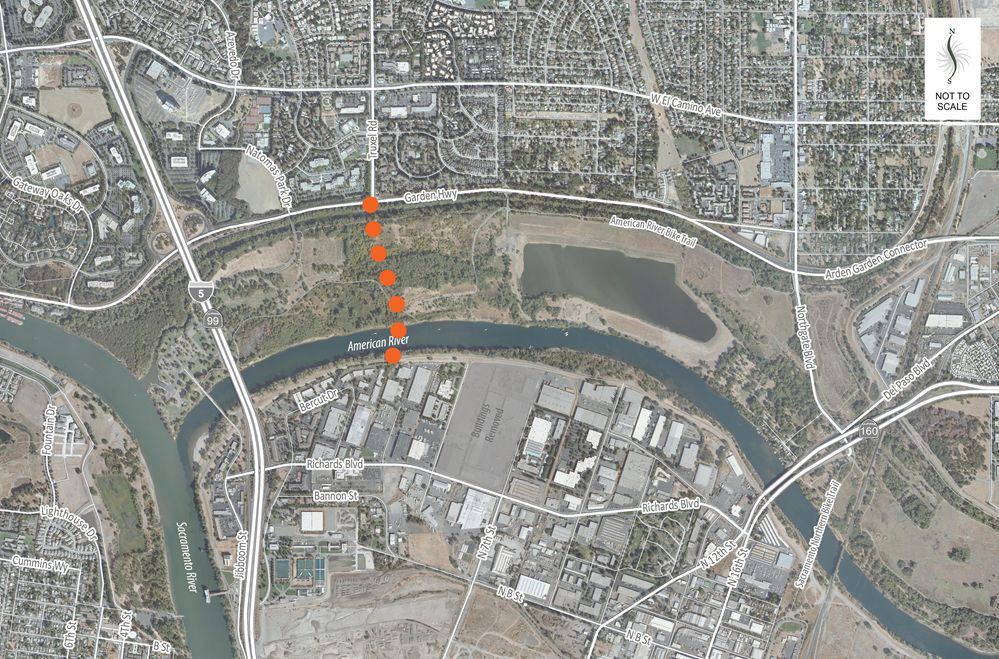
The City of Sacramento undertook an engineering feasibility study for a new multi-modal bridge across the lower American River between Truxel Road and Sequoia Pacific Boulevard to better connect North and South Natomas with the Central City.
In 2013 the City of Sacramento completed the American River crossings alternatives study, and City Council adopted the vision for a new multi-modal crossing at Truxel Road as the preferred alignment. The Truxel Bridge alignment was chosen based on its ability to address limited connectivity across the lower American River which creates a barrier to economic activity, land use development, social exchanges and access to jobs within the Central City by communities just north of the river including South Natomas and North Natomas where a significant portion of Sacramento City residents live, and a considerable amount of residential growth is planned.
Currently, there is a lack of direct multi-modal crossings over the American River, which discourages alternative modes of travel besides driving, therefore resulting in higher greenhouse gas emissions, higher vehicle miles traveled (VMT) due to longer trips, inefficient routes for transit services, and reduced public health and air quality. Additionally, this limited connectivity leads to longer emergency response times and can hinder evacuation during future natural disasters.
The purpose of the study was to refine the adopted alternative for the new bridge by conducting an inclusive public outreach and engagement process in collaboration with the detailed engineering and environmental analysis. The neighboring communities, including the priority populations who have been historically under-represented, as well as the larger public were engaged through community-based engagement to ensure the bridge fits within the context of the existing communities and serves the needs of the community. The project team gathered feedback on bridge configuration concepts, constraints analysis and design drawings. A few of the key elements that required stakeholder input included avoidance of known constraints, minimizing impacts to the Lower American River and associated wildlife, configuration of right-of-way on the bridge for all modes of travel, and connections to existing bicycle and pedestrian pathways.
Community Benefits
A new crossing at Truxel Road will have several community benefits including:
- Improving multi-modal connectivity for the South Natomas and North Natomas communities and overall improved regional connectivity.
- Encouraging alternate modes of travel besides driving by providing safe and efficient routes for pedestrians, bicyclists, and transit users across the American River.
- Reducing VMT resulting in lower greenhouse gas (GHG) emissions by providing a shorter, more direct route between communities on either side of the American River.
- Providing a framework for future development and transportation projects in the surrounding area, including a planned Kaiser Permanente medical facility just south of the American River.
- Supporting access for social services, jobs, recreation, local destinations, and education.
Cost and Funding
The Conceptual Plan for the Truxel Bridge was funded by a Caltrans Sustainability grant obtained by the City of Sacramento in partnership with the Sacramento Area Council of Governments (SACOG) and supplemented by local funds from the Sacramento Regional Transit District and developer fees. The overall cost of the Truxel Bridge, which is estimated at nearly $228 million, is anticipated to be funded through a combination of Infrastructure Investment and Jobs Act (IIJA) and other federal funds, the Road Repair and Accountability Act (SB1) and other state funds, and a variety of local funding sources, including a future transportation sales tax and developer impact fees.
Community Involvement
The Truxel Bridge Concept and Feasibility Study included a robust community engagement program that involved the community throughout the process and obtained input at key touchpoints.
City Council Hearing – February 18, 2025
The feasibility study and the concepts developed were presented to City Council for approval and the selection of a preferred alternative. The all-modes Alternative 3B was adopted as the concept for further development.
Active Transportation Commission – January 16, 2025
The feasilbility study and the concepts developed were presented to the Active Transportation Commission for an advisory vote on a preferred alternative.
Community Open House – November 13, 2024
As the feasibility study approached completion, the community was invited to hear from the City about some of the study conclusions and next steps for the project and share their thoughts.
- Wednesday, November 13 from 5:30 – 7:00 p.m.
- SMUD Museum of Science and Curiosity (MOSAC), 400 Jibboom Street, Sacramento
Stakeholder Focus Group Meeting – April 9, 2024
On April 9, the Truxel Bridge project team held a stakeholder focus group meeting with 10 representatives from partner organizations and agencies to gather feedback on the revised options for bridge cross sections and mix of uses.
Online Community Questionnaire – February 2024
The online questionnaire is now closed.
Community conversation – January 10, 2024
Our first community conversation was held on January 10 from 5:30 at the Read Academy.
Schedule
 open_in_full
Resources
Frequently Asked Questions
Can the project be built if there are environmental impacts identified?
Yes; most projects have some level of impact to the environment, but it is critical that environmental impacts are identified, disclosed to the public, and minimized. The Truxel Road Bridge project will go through an environmental clearance process which consists of identifying, documenting, analyzing, and mitigating impacts to sensitive environmental resources. The City of Sacramento will be the lead agency for the California Environmental Quality Act (CEQA) process. The objective of CEQA is to disclose to decision makers and the public the environmental effects of proposed activities. The Truxel Road Bridge CEQA document would discuss impacts to environmental resources and would contain mitigation measures that either avoid, minimize, or mitigate impacts. The draft CEQA document would be circulated, allowing the public to review and comment. The final CEQA document would contain responses to comments received, and after considering the final EIR, the City of Sacramento may decide whether or how to approve or carry out the project. During and following the environmental document, various permits and approvals would need to be secured from many regional, state, and federal regulatory agencies that are responsible for overseeing laws that protect resources. These regulatory agencies will enforce additional avoidance, minimization, and mitigation measures associated with environmental impacts of the project.
Can a different bridge location be considered as one of the alternatives?
After the need for an American River bridge crossing was identified, the City of Sacramento completed the American River Crossing Alternatives Study. This study evaluated eight (8) different bridge locations to cross the American River between Jibboom Street and State Route 160, with the goal of connecting Sacramento’s Central City and South Natomas. In 2013, the Truxel Road alignment (between Truxel Road/Garden Highway and Sequoia Pacific Boulevard) was selected as the preferred alternative for a new all-modes crossing of the Lower American River because it best met the specific objectives of the study. Bicycle and pedestrian improvements to the I-5 bridge and reconfiguring the Northgate/I-5 interchange were also adopted for further consideration. Council approved the application and award of grant funding from Caltrans to advance the design options for this specific crossing location. A bridge in the Truxel location is also consistent with the adopted crossing location for the future Sacramento Regional Transit light rail extension from the Central City, the American River Parkway Plan, the City of Sacramento’s 2035 General Plan, and numerous Specific Plans.
Will the environmental document require consideration of multiple alternatives?
At this time, it is anticipated that the project’s CEQA document will be an Environmental Impact Report. The City will be responsible for selecting feasible project alternatives that accomplish the project’s objectives and that also may avoid or substantially lessen significant environmental effects. Once the initial environmental analysis has progressed, the City will determine which, if any, additional build alternatives should be included in the EIR to foster informed decision making and public participation.
Can a bridge without cars be considered as one of the alternatives?
At this time, the project addresses the need for a local jurisdiction multi-modal crossing of the lower American River which has been established in the Sacramento General Plan and recognized in the Metropolitan Transportation Plan/Sustainable Communities Strategy 2035, Sacramento Area Council of Governments, 2012. Some of the key objectives of the proposed project include:
- Improve connectivity across the Lower American River between the Central City and South Natomas for all modes of travel in order to enhance accessibility to resources, jobs, commerce, and social exchanges.
- Increase evacuation and emergency/disaster response options for Central City and South Natomas residents and businesses.
- Provide local connectivity between the Central City and South Natomas to reduce reliance of local trips on state and interstate facilities.
If a bridge without cars is considered as an alternative, it would not accomplish most of the project’s basic objectives.
Project-related documents for download.
Contact
Fedolia “Sparky” Harris, Project Manager
(916) 808-2996
fharris@cityofsacramento.org
ON THIS PAGE