- City Departments
-
-
Community Development
-
Community Response
-
Convention and Cultural Services
-
Finance
-
Fire Department
-
Human Resources
-
Information Technology
-
Mayor and Council
-
Office of Public Safety Accountability
-
Office of the City Attorney
-
Office of the City Auditor
-
Office of the City Clerk
-
Office of the City Manager
-
Office of the City Treasurer
-
Police Department
-
Public Works
-
Utilities
-
Youth, Parks, & Community Enrichment
-
- Browse by categories
-
-
hiking Activities
-
pets Animals & Pets
-
domain_add Building & Planning
-
store Business
-
account_tree City Administration
-
category City Assets & Data
-
explore City Regions
-
diversity_4 Community Support
-
theater_comedy Culture & History
-
business_center Employment
-
directions Infrastructure
-
gavel Law, Code & Compliance
-
payments Money
-
park Outdoors & Sustainability
-
local_police Safety
-
directions_car Transportation
-
delete_sweep Utility Services
-
Use the menus above to navigate by City Departments or Categories.
- Convention and Cultural Services
- Arts and Culture
- Convention and Cultural Services
- Convention and Cultural Services
- Convention and Cultural Services
- Convention and Cultural Services
- Home
- Arts and Culture
- Arts and Culture
- Arts and Culture
- Arts and Culture
- Arts and Culture
- Arts and Culture
- Convention and Cultural Services
- Recreation
- Recreation
- Youth, Parks, & Community Enrichment
- Community Engagement
- Community Engagement
- About YPCE
- Hart Senior Center
- Recreation
- Youth Workforce Development
- Older Adult Services
- Youth, Parks, & Community Enrichment
- Long Range
- Youth, Parks, & Community Enrichment
- Recreation
- Recreation
- Recreation
- Home
- Youth, Parks, & Community Enrichment
- About YPCE
- About YPCE
- Older Adult Services
- Recreation
- Home
- Parking
- Innovation and Grants
- Aquatics
- CCS Partners
- Convention and Cultural Services
- Community Engagement
- District 7 - Rick Jennings
- Request a Permit
- CCS Partners
- Fire Department
- About YPCE
- Recycling & Solid Waste
- River District Specific Plan
- Convention and Cultural Services
- CCS Partners
- Emergency Management
- CCS Partners
- Commercial Waste Services
- Home
- Recreation
- Access Leisure
- Recreation
- Recreation
- Recreation
- Specialty Parks
- Specialty Parks
- Permits for YPCE
- Recreation
- Youth, Parks, & Community Enrichment
- About YPCE
- Youth, Parks, & Community Enrichment
- Aquatics
- Recreation
- Home
- Animal Care
- Animal Care
- Community Development
- Animal Care
- Animal Care
- Animal Care
- Animal Care
- Animal Care
- Animal Care
- Specialty Parks
- Animal Care
- Animal Care
- Street Landscape Maintenance
- Accessory Dwelling Units
- City Government
- Community Development
- Building
- Contact CDD
- Building
- Building
- Building
- Building
- Business Waste Requirements
- Commercial Waste Services
- Maintenance Services
- Procurement Services Division
- Parks
- Utilities
- Public Works
- Engineering
- Fire Prevention
- Building
- Building
- Building
- Building
- Engineering
- Home
- Public Works
- Housing
- Engineering
- Housing
- Planning
- Fire Prevention
- Contact CDD
- Building
- Recycling & Solid Waste
- Fire Prevention
- Fire Prevention
- Community Development
- Community Development
- Building Programs
- Community Development
- Transportation
- Locate & Grow in Sacramento
- Planning
- Planning
- Planning
- Climate Action Initiatives
- Planning
- Planning
- Parks
- Community Development
- Community Development
- Planning
- List of City Manager's Office Projects and Programs
- Public Works
- Planning
- Planning
- Public Works
- Transportation
- Planning
- Planning
- Engineering
- 102-Acre Site
- Community Development Meetings and Hearings
- Major Planning Projects
- Locate & Grow in Sacramento
- Major Planning Projects
- Planning
- City Government
- Innovation and Economic Development
- Code Compliance
- Revenue Division
- Revenue Division
- Innovation and Economic Development
- Office of the City Manager
- Recycling & Solid Waste
- Business
- Business
- Procurement Services Division
- Revenue Division
- Business
- Major Planning Projects
- City Auditor Reports
- City Auditor Reports
- Cannabis Management
- Cannabis Management
- Cannabis Management
- Business Operations Tax
- Cannabis Management
- Office of the City Manager
- Cannabis Management
- City Auditor Reports
- Cannabis Management
- Major Planning Projects
- Parking
- COVID-19 Relief & Recovery
- Innovation and Economic Development
- Innovation and Economic Development
- Business
- Community Engagement
- Innovation and Economic Development
- Innovation and Economic Development
- Innovation and Economic Development
- Innovation and Economic Development
- Office of the City Manager
- Business
- Business
- Innovation and Economic Development
- Innovation and Economic Development
- Business
- Innovation and Economic Development
- Office of the City Manager
- Business
- Finance
- Accounting Division
- Police Services
- Procurement Services Division
- City Government
- Code Compliance Programs
- Code Compliance Programs
- Commercial Waste Services
- Procurement Services Division
- Procurement Services Division
- Home
- Commercial Waste Services
- Procurement Services Division
- Finance
- Finance
- Procurement Services Division
- Procurement Services Division
- Office of the City Auditor
- Police Transparency
- Office of the City Auditor
- Office of the City Auditor
- Accounting Division
- Office of the City Clerk
- Home
- About YPCE
- Arts and Culture
- Diversity and Equity
- Records Management
- Office of the City Auditor
- Director Hearings
- Director Hearings
- Director Hearings
- Director Hearings
- District 1 - Lisa Kaplan
- District 2 - Roger Dickinson
- City Auditor Reports
- Office of the City Clerk
- About YPCE
- Police Transparency
- Home
- Records Management
- Office of the City Manager
- Office of the City Manager
- Neighborhood Directory
- Neighborhood Directory
- Community Engagement
- Office of the City Clerk
- Office of the City Manager
- Innovation and Grants
- Office of the City Manager
- Office of the City Manager
- Office of the City Manager
- Home
- River District Specific Plan
- City Government
- Engineering
- City Government
- Long Range
- City Government
- City Government
- City Government
- City Government
- Information Technology
- Camp Sacramento
- Parking
- About YPCE
- Finance
- Drinking Water Quality
- Utilities
- Office of Public Safety Accountability
- Pay Your Utility Bill
- Police Services
- Police Services
- Marina
- Police Services
- Contact Us
- Police Services
- Office of the City Clerk
- Home
- Mayor and Council
- Mayor and Council
- Mayor and Council
- Mayor and Council
- Mayor and Council
- Mayor and Council
- Mayor and Council
- Mayor and Council
- Mayor and Council
- Office of the City Clerk
- Mayor and Council
- Home
- Diversity and Equity
- Office of the City Auditor
- Office of Public Safety Accountability
- About the City Attorney's Office
- Office of the City Auditor
- Office of the City Auditor
- Police Department
- Maps and Geographic Information Systems
- Office of Public Safety Accountability
- Police Department
- City Government
- Office of the City Auditor
- Sacramento for All: Housing Education Resource Center
- 102-Acre Site
- 102-Acre Site
- 102-Acre Site
- Public Works
- Construction & Demolition Recycling
- About SPD
- Facilities & Real Property Management
- Public Works
- Adult Sports Activities and Resources
- Climate Action Initiatives
- Fleet Services
- Public Works
- Director Hearings
- Director Hearings
- Director Hearings
- Director Hearings
- Director Hearings
- Director Hearings
- General Plans
- Police Transparency
- Convention and Cultural Services
- Legislative Management
- District 1 - Lisa Kaplan
- Home
- Maps and Geographic Information Systems
- Office of the City Clerk
- Police Services
- Office of the City Auditor
- Office of Public Safety Accountability
- About the City Attorney's Office
- Office of the City Auditor
- Office of the City Auditor
- Police Department
- Maps and Geographic Information Systems
- Office of Public Safety Accountability
- Police Department
- City Government
- Office of the City Auditor
- Mayor and Council
- Mayor and Council
- Mayor and Council
- Mayor and Council
- Mayor and Council
- Mayor and Council
- Mayor and Council
- Mayor and Council
- Maps and Geographic Information Systems
- City Elections
- Police News
- Community Resources and Financial Empowerment
- Long Range
- Community Engagement
- Youth Workforce Development
- Locate & Grow in Sacramento
- Major Planning Projects
- Public Art Projects
- Engineering
- 102-Acre Site
- Community Development Meetings and Hearings
- Major Planning Projects
- Locate & Grow in Sacramento
- Major Planning Projects
- Planning
- Youth, Parks, & Community Enrichment
- Specialty Parks
- Long Range
- City Government
- Parking
- Transportation Projects
- About YPCE
- Home
- Engineering Programs & Services
- About OAC
- Youth, Parks, & Community Enrichment
- Maintenance Services
- City Government
- Older Adult Services
- Housing
- Home
- Youth, Parks, & Community Enrichment
- About YPCE
- About YPCE
- Older Adult Services
- Recreation
- Home
- 102-Acre Site
- Sacramento for All: Housing Education Resource Center
- Long Range
- City Auditor Reports
- Priority Projects/Investments
- Community Engagement
- Innovation and Economic Development
- Diversity and Equity
- Join Sacramento Fire
- Innovation and Economic Development
- Transportation
- Responding to Homelessness
- Office of the City Manager
- District 5 - Caity Maple
- Measure U
- Office of the City Manager
- Police News
- Safety and Crime Prevention Tips
- Youth Workforce Development
- Police Department
- Community Development Meetings and Hearings
- River District Specific Plan
- Diversity and Equity
- Older Adult Services
- Vision Zero: Transportation Safety
- About Access Leisure
- Access Leisure Sports
- Access Leisure Sports
- Cannabis Management
- Office of the City Auditor
- Office of the City Auditor
- Human Resources
- Financial Empowerment
- Home
- Innovation and Economic Development
- Police Community Programs
- Community Response
- Community Response
- Workforce Development
- Police Community Programs
- Community Response
- Mayor McCarty Memo
- Community Response
- Office of the City Manager
- Planning
- Housing
- Housing Development Toolkit
- City and County Partnership
- Housing Development Toolkit
- Housing
- Housing
- City and County Partnership
- Code Compliance
- Housing
- Revenue Division
- Priority Projects/Investments
- Housing
- Long Range
- District 1 - Lisa Kaplan
- About YPCE
- Older Adult Services
- Recreation
- Older Adult Services
- Youth, Parks, & Community Enrichment
- Youth, Parks, & Community Enrichment
- Older Adult Services
- Housing
- Home
- District 5 - Caity Maple
- About the Office of the City Auditor
- Join Sacramento Fire
- Animal Care
- District 7 Resources
- District 1 - Lisa Kaplan
- Community Engagement
- Police Community Programs
- About YPCE
- Police Department
- Youth, Parks, & Community Enrichment
- Specialty Parks
- Aquatics Programs
- Funding and Grants for Arts and Culture
- District 7 Resources
- Youth, Parks, & Community Enrichment
- CCS Partners
- Join Sacramento Fire
- About YPCE
- Aquatics Programs
- Recreation
- Aquatics
- City Auditor Reports
- Youth, Parks, & Community Enrichment
- Police Community Programs
- Youth, Parks, & Community Enrichment
- Public Art Projects
- Youth, Parks, & Community Enrichment
- Youth, Parks, & Community Enrichment
- Police Community Programs
- Youth, Parks, & Community Enrichment
- Recreation
- Recreation
- Youth, Parks, & Community Enrichment
- Home
- Convention and Cultural Services
- Arts and Culture
- Convention and Cultural Services
- Convention and Cultural Services
- Convention and Cultural Services
- Convention and Cultural Services
- Home
- Arts and Culture
- Arts and Culture
- Arts and Culture
- Arts and Culture
- Arts and Culture
- Arts and Culture
- Convention and Cultural Services
- Parking
- Innovation and Grants
- Aquatics
- CCS Partners
- Convention and Cultural Services
- Community Engagement
- District 7 - Rick Jennings
- Request a Permit
- CCS Partners
- Fire Department
- About YPCE
- Recycling & Solid Waste
- River District Specific Plan
- Convention and Cultural Services
- CCS Partners
- Emergency Management
- CCS Partners
- Commercial Waste Services
- Home
- Sacramento for All: Housing Education Resource Center
- Sacramento for All: Housing Education Resource Center
- Convention and Cultural Services
- About the City Attorney's Office
- Specialty Parks
- Planning
- Public Art Projects
- About Sacramento Fire
- CCS Partners
- Public Works
- Police Department
- About Access Leisure
- Access Leisure Sports
- Access Leisure Sports
- Cannabis Management
- Office of the City Auditor
- Office of the City Auditor
- Human Resources
- Financial Empowerment
- Home
- Innovation and Economic Development
- Police Community Programs
- Human Resources
- Human Resources
- Human Resources
- Human Resources
- Home
- Human Resources
- Payroll Division
- Camp Sacramento
- HR Documents & Resources
- Human Resources
- Human Resources
- Home
- District 7 Resources
- Fire Department
- Leisure Enrichment
- Employee & Retiree Benefits
- Youth Workforce Development
- Sacramento START
- Police Services
- District 5 - Caity Maple
- About the Office of the City Auditor
- Join Sacramento Fire
- Animal Care
- District 7 Resources
- District 1 - Lisa Kaplan
- Community Engagement
- Police Community Programs
- About YPCE
- Police Department
- Funding and Grants for Arts and Culture
- Youth Workforce Development
- Innovation and Economic Development
- Transportation Projects
- Transportation Projects
- Transportation Projects
- Transportation Projects
- Current Transportation Efforts, Plans and Programs
- Utilities
- Utilities
- Utilities
- Utilities
- Utilities
- Utilities
- Utilities
- Home
- Utilities
- Information Technology
- Information Technology
- City Government
- Information Technology
- Information Technology
- Information Technology
- Information Technology
- Home
- Fire Operations
- Information Technology
- Information Technology
- Collection Calendar
- City Government
- Information Technology
- Infrastructure Finance Division
- Home
- Infrastructure Finance Division
- Finance
- Infrastructure Finance Division
- Infrastructure Finance Division
- Building Programs
- Utilities
- Utilities
- Office of the City Manager
- Utilities
- Utilities
- Utilities
- Utilities
- Utilities
- Utilities
- Home
- Safety Tips
- Construction Coordination
- Transportation
- Transportation
- Utilities
- Public Works
- Maintenance Services
- Public Works
- Police Community Programs
- Home
- Survey Services
- Maintenance Services
- Maintenance Services
- Maintenance Services
- Maintenance Services
- Collection Services
- Tree Permits and Ordinances
- Public Works
- Transportation
- Transportation
- Engineering
- Transportation
- Transportation
- Park Planning & Development
- Parks
- Public Works
- Transportation Projects
- Parks
- Transportation Projects
- Transportation Projects
- Transportation Projects
- Utilities
- Utilities
- Utilities
- Stormwater Quality
- Utilities
- Utilities
- Utilities
- Stormwater Quality
- Home
- Community Development
- Community Development
- Code Compliance
- Code Compliance
- Community Development
- Code Compliance
- Code Compliance
- Community Development
- Fire Prevention
- Construction & Demolition Recycling
- Code Compliance
- Recycling & Solid Waste
- Code Compliance
- Franchise Waste Haulers
- Residential Permit Parking (RPP)
- Code Compliance
- Fire Prevention
- Contact CDD
- Building
- Recycling & Solid Waste
- Fire Prevention
- Fire Prevention
- Commercial Waste Services
- Cannabis Management
- City Government
- Recycling & Solid Waste
- Commercial Waste Services
- Disabled Person Parking
- Electric Vehicle Parking
- Fire Code Enforcement
- Police Transparency
- Commercial Waste Services
- Contact Parking Services
- Residential Permit Parking (RPP)
- Community Development
- Request a Permit
- Request a Permit
- Fire Prevention
- Contact CDD
- Public Records
- Code Compliance
- Revenue Division
- Cannabis Management
- Request a Permit
- Request a Permit
- Engineering
- Request a Permit
- Housing Development Incentives
- Arts and Culture
- Housing Development Incentives
- Public Works
- Public Works
- Building
- Youth, Parks, & Community Enrichment
- Locate & Grow in Sacramento
- Building
- Request a Permit
- Public Works
- Revenue Division
- Commercial Waste Services
- Building Programs
- Mayor McCarty Memo
- Urban Forestry
- Planning
- Finance
- Accounting Division
- Home
- Accounting Division
- City Auditor Reports
- Collection Services
- Payroll Division
- Office of the City Manager
- Finance
- Budget Division
- Budget Division
- Home
- Measure U
- Mayor McCarty Memo
- Access Leisure
- Climate and Sustainability Planning
- Pay Your Utility Bill
- Hart Senior Center
- Recycling & Solid Waste
- Discount Deals
- Water Conservation
- Youth, Parks, & Community Enrichment
- Aquatics
- Finance
- Utility User Tax
- Recreation
- Office of the City Treasurer
- Office of the City Treasurer
- Office of the City Treasurer
- Home
- Office of the City Treasurer
- Parking
- COVID-19 Relief & Recovery
- Innovation and Economic Development
- Innovation and Economic Development
- Business
- Community Engagement
- Innovation and Economic Development
- Innovation and Economic Development
- Innovation and Economic Development
- Innovation and Economic Development
- Office of the City Manager
- Business
- Business
- Innovation and Economic Development
- Innovation and Economic Development
- Business
- Innovation and Economic Development
- CORE
- Convention and Cultural Services
- Stormwater Quality
- Funding and Grants for Arts and Culture
- Funding and Grants for Arts and Culture
- Funding and Grants for Arts and Culture
- Economic Gardening
- Arts and Culture
- Forward Together Pilot Grant for North Sacramento
- Innovation and Grants
- Recycling & Solid Waste
- Innovation and Grants
- Innovation and Grants
- Youth, Parks, & Community Enrichment
- About OAC
- Engineering
- Infrastructure Finance Division
- Home
- Infrastructure Finance Division
- Finance
- Infrastructure Finance Division
- Infrastructure Finance Division
- Building Programs
- Office of the City Treasurer
- Office of the City Treasurer
- Home
- Office of the City Treasurer
- Building
- Revenue Division
- Cannabis Business Operating Permits
- Recycling & Solid Waste
- Revenue Division
- Development Standards
- Development Standards
- Emergency Medical Services
- Finance
- Community Engagement
- Marina
- Household Hazardous Waste
- Public Works
- Community Development
- Utilities
- City Government
- Finance
- Animal Care
- Home
- Revenue Division
- Development Standards
- Marina
- Permits for YPCE
- Revenue Division
- Infrastructure Finance Division
- Home
- Workforce Development
- List of City Manager's Office Projects and Programs
- About YPCE
- Revenue Division
- Budget Division
- Revenue Division
- Revenue Division
- Transportation
- Current Transportation Efforts, Plans and Programs
- Transportation Projects
- Climate Action Initiatives
- Housing
- Public Works
- Current Transportation Efforts, Plans and Programs
- Current Transportation Efforts, Plans and Programs
- Current Transportation Efforts, Plans and Programs
- Current Transportation Efforts, Plans and Programs
- Public Works
- Home
- Recreation
- Recreation
- Street Landscape Maintenance
- Climate Action and Sustainability
- Climate Action and Sustainability
- Public Works
- Climate Action and Sustainability
- Climate and Sustainability Planning
- Planning
- Fleet Services
- Climate Action and Sustainability
- Procurement Services Division
- Business Waste Requirements
- Permit Services
- Utilities
- Climate Action and Sustainability
- Utilities
- Recreation
- About YPCE
- Public Works
- Youth, Parks, & Community Enrichment
- About YPCE
- Public Art Projects
- Commercial Waste Services
- Permits for YPCE
- About YPCE
- Home
- Current Transportation Efforts, Plans and Programs
- Recreation
- Access Leisure
- Recreation
- Recreation
- Recreation
- Specialty Parks
- Specialty Parks
- Permits for YPCE
- Recreation
- Youth, Parks, & Community Enrichment
- About YPCE
- Youth, Parks, & Community Enrichment
- Aquatics
- Recreation
- Home
- Park Planning & Development
- Parks
- Public Works
- Transportation Projects
- Parks
- Transportation Projects
- Transportation Projects
- Transportation Projects
- Urban Forestry
- Parks
- Public Works
- Parks
- Home
- Urban Forestry
- Urban Forestry
- Urban Forestry
- Climate Action Initiatives
- Maintenance Services
- Safety Tips
- Office of the City Manager
- Specialty Parks
- Community Response
- Community Response
- Home
- Office of the City Manager
- Contact Us
- Contact Us
- Crime and Safety
- Crime and Safety
- Crime and Safety
- Crime and Safety
- Crime and Safety
- Police Services
- Fire Prevention
- Crime and Safety
- Police Services
- Crime and Safety
- Pay Your Utility Bill
- Crime and Safety
- Office of the City Auditor
- City Auditor Reports
- Fire Prevention
- Office of the City Manager
- Fire Department
- Join Sacramento Fire
- Crime and Safety
- Join Sacramento Fire
- Emergency Management
- Fire Department
- Fire Department
- Fire Department
- Fire Department
- Home
- Fire Department
- Fire Department
- Fire Department
- Home
- Fire Department
- Fire Prevention
- Contact CDD
- Building
- Recycling & Solid Waste
- Fire Prevention
- Fire Prevention
- Request a Permit
- Request a Permit
- Police Services
- Police Services
- Request a Permit
- Request a Permit
- Police Services
- Police Department
- Request a Permit
- Police Services
- Police Services
- Police Services
- Police Services
- Public Information Office
- Police Services
- Home
- Police Department
- Home
- Police Department
- Police Department
- Request a Permit
- Police Services
- Police Services
- Police Services
- Police Services
- Police Services
- Police Services
- Police Department
- Emergency Management
- Police Department
- Information Technology
- Flood Preparedness
- Fire Department
- District 1 - Lisa Kaplan
- Utilities
- Utilities
- Office of the City Manager
- Utilities
- Utilities
- Utilities
- Utilities
- Utilities
- Utilities
- Home
- Safety Tips
- Safety Tips
- Office of the City Manager
- Specialty Parks
- Transportation
- Current Transportation Efforts, Plans and Programs
- Transportation Projects
- Climate Action Initiatives
- Housing
- Public Works
- Current Transportation Efforts, Plans and Programs
- Current Transportation Efforts, Plans and Programs
- Current Transportation Efforts, Plans and Programs
- Current Transportation Efforts, Plans and Programs
- Public Works
- Home
- Current Transportation Efforts, Plans and Programs
- Transportation Technology
- Sacramento Valley Station
- Current Transportation Efforts, Plans and Programs
- Parking
- Fleet Services
- Climate Action Initiatives
- Current Transportation Efforts, Plans and Programs
- Police Services
- Marina
- Marina
- Public Works
- Housing
- Home
- Public Works
- Collection Services
- Sacramento Valley Station
- Vision Zero: Transportation Safety
- Current Transportation Efforts, Plans and Programs
- Transportation Projects
- Public Works
- Long Range
- Current Transportation Efforts, Plans and Programs
- Transportation
- Public Works
- Home
- Public Works
- File a Police Report
- Public Works
- Transportation
- Transportation
- Transportation
- Transportation
- Transportation
- Transportation
- Engineering
- Transportation
- Utilities
- Utilities
- Utilities
- Utilities
- Utilities
- Utilities
- Utilities
- Home
- Utilities
- Recycling & Solid Waste
- Recycling & Solid Waste
- Recycling & Solid Waste
- Recycling & Solid Waste
- Recycling & Solid Waste
- Recycling & Solid Waste
- Recycling & Solid Waste
- Public Works
- Climate Action Initiatives
- Recycling & Solid Waste
- Recycling & Solid Waste
- Recycling & Solid Waste
- Recycling & Solid Waste
- Recycling & Solid Waste
- Recycling & Solid Waste
- Recycling & Solid Waste
- Recycling & Solid Waste
- Recycling & Solid Waste
- Public Works
- Climate Action Initiatives
- Recycling & Solid Waste
- Utilities
- Utilities
- Utilities
- Stormwater Quality
- Utilities
- Utilities
- Utilities
- Stormwater Quality
- Home
- City Departments
-
-
Community Development
-
Community Response
-
Convention and Cultural Services
-
Finance
-
Fire Department
-
Human Resources
-
Information Technology
-
Mayor and Council
-
Office of Public Safety Accountability
-
Office of the City Attorney
-
Office of the City Auditor
-
Office of the City Clerk
-
Office of the City Manager
-
Office of the City Treasurer
-
Police Department
-
Public Works
-
Utilities
-
Youth, Parks, & Community Enrichment
-
- Browse by categories
-
-
hiking Activities
-
pets Animals & Pets
-
domain_add Building & Planning
-
store Business
-
account_tree City Administration
-
category City Assets & Data
-
explore City Regions
-
diversity_4 Community Support
-
theater_comedy Culture & History
-
business_center Employment
-
directions Infrastructure
-
gavel Law, Code & Compliance
-
payments Money
-
park Outdoors & Sustainability
-
local_police Safety
-
directions_car Transportation
-
delete_sweep Utility Services
-
Use the menus above to navigate by City Departments or Categories.
You can also use the Search function below to find specific content on our site.
- Convention and Cultural Services
- Arts and Culture
- Convention and Cultural Services
- Convention and Cultural Services
- Convention and Cultural Services
- Convention and Cultural Services
- Home
- Arts and Culture
- Arts and Culture
- Arts and Culture
- Arts and Culture
- Arts and Culture
- Arts and Culture
- Convention and Cultural Services
- Recreation
- Recreation
- Youth, Parks, & Community Enrichment
- Community Engagement
- Community Engagement
- About YPCE
- Hart Senior Center
- Recreation
- Youth Workforce Development
- Older Adult Services
- Youth, Parks, & Community Enrichment
- Long Range
- Youth, Parks, & Community Enrichment
- Recreation
- Recreation
- Recreation
- Home
- Youth, Parks, & Community Enrichment
- About YPCE
- About YPCE
- Older Adult Services
- Recreation
- Home
- Parking
- Innovation and Grants
- Aquatics
- CCS Partners
- Convention and Cultural Services
- Community Engagement
- District 7 - Rick Jennings
- Request a Permit
- CCS Partners
- Fire Department
- About YPCE
- Recycling & Solid Waste
- River District Specific Plan
- Convention and Cultural Services
- CCS Partners
- Emergency Management
- CCS Partners
- Commercial Waste Services
- Home
- Recreation
- Access Leisure
- Recreation
- Recreation
- Recreation
- Specialty Parks
- Specialty Parks
- Permits for YPCE
- Recreation
- Youth, Parks, & Community Enrichment
- About YPCE
- Youth, Parks, & Community Enrichment
- Aquatics
- Recreation
- Home
- Animal Care
- Animal Care
- Community Development
- Animal Care
- Animal Care
- Animal Care
- Animal Care
- Animal Care
- Animal Care
- Specialty Parks
- Animal Care
- Animal Care
- Street Landscape Maintenance
- Accessory Dwelling Units
- City Government
- Community Development
- Building
- Contact CDD
- Building
- Building
- Building
- Building
- Business Waste Requirements
- Commercial Waste Services
- Maintenance Services
- Procurement Services Division
- Parks
- Utilities
- Public Works
- Engineering
- Fire Prevention
- Building
- Building
- Building
- Building
- Engineering
- Home
- Public Works
- Housing
- Engineering
- Housing
- Planning
- Fire Prevention
- Contact CDD
- Building
- Recycling & Solid Waste
- Fire Prevention
- Fire Prevention
- Community Development
- Community Development
- Building Programs
- Community Development
- Transportation
- Locate & Grow in Sacramento
- Planning
- Planning
- Planning
- Climate Action Initiatives
- Planning
- Planning
- Parks
- Community Development
- Community Development
- Planning
- List of City Manager's Office Projects and Programs
- Public Works
- Planning
- Planning
- Public Works
- Transportation
- Planning
- Planning
- Engineering
- 102-Acre Site
- Community Development Meetings and Hearings
- Major Planning Projects
- Locate & Grow in Sacramento
- Major Planning Projects
- Planning
- City Government
- Innovation and Economic Development
- Code Compliance
- Revenue Division
- Revenue Division
- Innovation and Economic Development
- Office of the City Manager
- Recycling & Solid Waste
- Business
- Business
- Procurement Services Division
- Revenue Division
- Business
- Major Planning Projects
- City Auditor Reports
- City Auditor Reports
- Cannabis Management
- Cannabis Management
- Cannabis Management
- Business Operations Tax
- Cannabis Management
- Office of the City Manager
- Cannabis Management
- City Auditor Reports
- Cannabis Management
- Major Planning Projects
- Parking
- COVID-19 Relief & Recovery
- Innovation and Economic Development
- Innovation and Economic Development
- Business
- Community Engagement
- Innovation and Economic Development
- Innovation and Economic Development
- Innovation and Economic Development
- Innovation and Economic Development
- Office of the City Manager
- Business
- Business
- Innovation and Economic Development
- Innovation and Economic Development
- Business
- Innovation and Economic Development
- Office of the City Manager
- Business
- Finance
- Accounting Division
- Police Services
- Procurement Services Division
- City Government
- Code Compliance Programs
- Code Compliance Programs
- Commercial Waste Services
- Procurement Services Division
- Procurement Services Division
- Home
- Commercial Waste Services
- Procurement Services Division
- Finance
- Finance
- Procurement Services Division
- Procurement Services Division
- Office of the City Auditor
- Police Transparency
- Office of the City Auditor
- Office of the City Auditor
- Accounting Division
- Office of the City Clerk
- Home
- About YPCE
- Arts and Culture
- Diversity and Equity
- Records Management
- Office of the City Auditor
- Director Hearings
- Director Hearings
- Director Hearings
- Director Hearings
- District 1 - Lisa Kaplan
- District 2 - Roger Dickinson
- City Auditor Reports
- Office of the City Clerk
- About YPCE
- Police Transparency
- Home
- Records Management
- Office of the City Manager
- Office of the City Manager
- Neighborhood Directory
- Neighborhood Directory
- Community Engagement
- Office of the City Clerk
- Office of the City Manager
- Innovation and Grants
- Office of the City Manager
- Office of the City Manager
- Office of the City Manager
- Home
- River District Specific Plan
- City Government
- Engineering
- City Government
- Long Range
- City Government
- City Government
- City Government
- City Government
- Information Technology
- Camp Sacramento
- Parking
- About YPCE
- Finance
- Drinking Water Quality
- Utilities
- Office of Public Safety Accountability
- Pay Your Utility Bill
- Police Services
- Police Services
- Marina
- Police Services
- Contact Us
- Police Services
- Office of the City Clerk
- Home
- Mayor and Council
- Mayor and Council
- Mayor and Council
- Mayor and Council
- Mayor and Council
- Mayor and Council
- Mayor and Council
- Mayor and Council
- Mayor and Council
- Office of the City Clerk
- Mayor and Council
- Home
- Diversity and Equity
- Office of the City Auditor
- Office of Public Safety Accountability
- About the City Attorney's Office
- Office of the City Auditor
- Office of the City Auditor
- Police Department
- Maps and Geographic Information Systems
- Office of Public Safety Accountability
- Police Department
- City Government
- Office of the City Auditor
- Sacramento for All: Housing Education Resource Center
- 102-Acre Site
- 102-Acre Site
- 102-Acre Site
- Public Works
- Construction & Demolition Recycling
- About SPD
- Facilities & Real Property Management
- Public Works
- Adult Sports Activities and Resources
- Climate Action Initiatives
- Fleet Services
- Public Works
- Director Hearings
- Director Hearings
- Director Hearings
- Director Hearings
- Director Hearings
- Director Hearings
- General Plans
- Police Transparency
- Convention and Cultural Services
- Legislative Management
- District 1 - Lisa Kaplan
- Home
- Maps and Geographic Information Systems
- Office of the City Clerk
- Police Services
- Office of the City Auditor
- Office of Public Safety Accountability
- About the City Attorney's Office
- Office of the City Auditor
- Office of the City Auditor
- Police Department
- Maps and Geographic Information Systems
- Office of Public Safety Accountability
- Police Department
- City Government
- Office of the City Auditor
- Mayor and Council
- Mayor and Council
- Mayor and Council
- Mayor and Council
- Mayor and Council
- Mayor and Council
- Mayor and Council
- Mayor and Council
- Maps and Geographic Information Systems
- City Elections
- Police News
- Community Resources and Financial Empowerment
- Long Range
- Community Engagement
- Youth Workforce Development
- Locate & Grow in Sacramento
- Major Planning Projects
- Public Art Projects
- Engineering
- 102-Acre Site
- Community Development Meetings and Hearings
- Major Planning Projects
- Locate & Grow in Sacramento
- Major Planning Projects
- Planning
- Youth, Parks, & Community Enrichment
- Specialty Parks
- Long Range
- City Government
- Parking
- Transportation Projects
- About YPCE
- Home
- Engineering Programs & Services
- About OAC
- Youth, Parks, & Community Enrichment
- Maintenance Services
- City Government
- Older Adult Services
- Housing
- Home
- Youth, Parks, & Community Enrichment
- About YPCE
- About YPCE
- Older Adult Services
- Recreation
- Home
- 102-Acre Site
- Sacramento for All: Housing Education Resource Center
- Long Range
- City Auditor Reports
- Priority Projects/Investments
- Community Engagement
- Innovation and Economic Development
- Diversity and Equity
- Join Sacramento Fire
- Innovation and Economic Development
- Transportation
- Responding to Homelessness
- Office of the City Manager
- District 5 - Caity Maple
- Measure U
- Office of the City Manager
- Police News
- Safety and Crime Prevention Tips
- Youth Workforce Development
- Police Department
- Community Development Meetings and Hearings
- River District Specific Plan
- Diversity and Equity
- Older Adult Services
- Vision Zero: Transportation Safety
- About Access Leisure
- Access Leisure Sports
- Access Leisure Sports
- Cannabis Management
- Office of the City Auditor
- Office of the City Auditor
- Human Resources
- Financial Empowerment
- Home
- Innovation and Economic Development
- Police Community Programs
- Community Response
- Community Response
- Workforce Development
- Police Community Programs
- Community Response
- Mayor McCarty Memo
- Community Response
- Office of the City Manager
- Planning
- Housing
- Housing Development Toolkit
- City and County Partnership
- Housing Development Toolkit
- Housing
- Housing
- City and County Partnership
- Code Compliance
- Housing
- Revenue Division
- Priority Projects/Investments
- Housing
- Long Range
- District 1 - Lisa Kaplan
- About YPCE
- Older Adult Services
- Recreation
- Older Adult Services
- Youth, Parks, & Community Enrichment
- Youth, Parks, & Community Enrichment
- Older Adult Services
- Housing
- Home
- District 5 - Caity Maple
- About the Office of the City Auditor
- Join Sacramento Fire
- Animal Care
- District 7 Resources
- District 1 - Lisa Kaplan
- Community Engagement
- Police Community Programs
- About YPCE
- Police Department
- Youth, Parks, & Community Enrichment
- Specialty Parks
- Aquatics Programs
- Funding and Grants for Arts and Culture
- District 7 Resources
- Youth, Parks, & Community Enrichment
- CCS Partners
- Join Sacramento Fire
- About YPCE
- Aquatics Programs
- Recreation
- Aquatics
- City Auditor Reports
- Youth, Parks, & Community Enrichment
- Police Community Programs
- Youth, Parks, & Community Enrichment
- Public Art Projects
- Youth, Parks, & Community Enrichment
- Youth, Parks, & Community Enrichment
- Police Community Programs
- Youth, Parks, & Community Enrichment
- Recreation
- Recreation
- Youth, Parks, & Community Enrichment
- Home
- Convention and Cultural Services
- Arts and Culture
- Convention and Cultural Services
- Convention and Cultural Services
- Convention and Cultural Services
- Convention and Cultural Services
- Home
- Arts and Culture
- Arts and Culture
- Arts and Culture
- Arts and Culture
- Arts and Culture
- Arts and Culture
- Convention and Cultural Services
- Parking
- Innovation and Grants
- Aquatics
- CCS Partners
- Convention and Cultural Services
- Community Engagement
- District 7 - Rick Jennings
- Request a Permit
- CCS Partners
- Fire Department
- About YPCE
- Recycling & Solid Waste
- River District Specific Plan
- Convention and Cultural Services
- CCS Partners
- Emergency Management
- CCS Partners
- Commercial Waste Services
- Home
- Sacramento for All: Housing Education Resource Center
- Sacramento for All: Housing Education Resource Center
- Convention and Cultural Services
- About the City Attorney's Office
- Specialty Parks
- Planning
- Public Art Projects
- About Sacramento Fire
- CCS Partners
- Public Works
- Police Department
- About Access Leisure
- Access Leisure Sports
- Access Leisure Sports
- Cannabis Management
- Office of the City Auditor
- Office of the City Auditor
- Human Resources
- Financial Empowerment
- Home
- Innovation and Economic Development
- Police Community Programs
- Human Resources
- Human Resources
- Human Resources
- Human Resources
- Home
- Human Resources
- Payroll Division
- Camp Sacramento
- HR Documents & Resources
- Human Resources
- Human Resources
- Home
- District 7 Resources
- Fire Department
- Leisure Enrichment
- Employee & Retiree Benefits
- Youth Workforce Development
- Sacramento START
- Police Services
- District 5 - Caity Maple
- About the Office of the City Auditor
- Join Sacramento Fire
- Animal Care
- District 7 Resources
- District 1 - Lisa Kaplan
- Community Engagement
- Police Community Programs
- About YPCE
- Police Department
- Funding and Grants for Arts and Culture
- Youth Workforce Development
- Innovation and Economic Development
- Transportation Projects
- Transportation Projects
- Transportation Projects
- Transportation Projects
- Current Transportation Efforts, Plans and Programs
- Utilities
- Utilities
- Utilities
- Utilities
- Utilities
- Utilities
- Utilities
- Home
- Utilities
- Information Technology
- Information Technology
- City Government
- Information Technology
- Information Technology
- Information Technology
- Information Technology
- Home
- Fire Operations
- Information Technology
- Information Technology
- Collection Calendar
- City Government
- Information Technology
- Infrastructure Finance Division
- Home
- Infrastructure Finance Division
- Finance
- Infrastructure Finance Division
- Infrastructure Finance Division
- Building Programs
- Utilities
- Utilities
- Office of the City Manager
- Utilities
- Utilities
- Utilities
- Utilities
- Utilities
- Utilities
- Home
- Safety Tips
- Construction Coordination
- Transportation
- Transportation
- Utilities
- Public Works
- Maintenance Services
- Public Works
- Police Community Programs
- Home
- Survey Services
- Maintenance Services
- Maintenance Services
- Maintenance Services
- Maintenance Services
- Collection Services
- Tree Permits and Ordinances
- Public Works
- Transportation
- Transportation
- Engineering
- Transportation
- Transportation
- Park Planning & Development
- Parks
- Public Works
- Transportation Projects
- Parks
- Transportation Projects
- Transportation Projects
- Transportation Projects
- Utilities
- Utilities
- Utilities
- Stormwater Quality
- Utilities
- Utilities
- Utilities
- Stormwater Quality
- Home
- Community Development
- Community Development
- Code Compliance
- Code Compliance
- Community Development
- Code Compliance
- Code Compliance
- Community Development
- Fire Prevention
- Construction & Demolition Recycling
- Code Compliance
- Recycling & Solid Waste
- Code Compliance
- Franchise Waste Haulers
- Residential Permit Parking (RPP)
- Code Compliance
- Fire Prevention
- Contact CDD
- Building
- Recycling & Solid Waste
- Fire Prevention
- Fire Prevention
- Commercial Waste Services
- Cannabis Management
- City Government
- Recycling & Solid Waste
- Commercial Waste Services
- Disabled Person Parking
- Electric Vehicle Parking
- Fire Code Enforcement
- Police Transparency
- Commercial Waste Services
- Contact Parking Services
- Residential Permit Parking (RPP)
- Community Development
- Request a Permit
- Request a Permit
- Fire Prevention
- Contact CDD
- Public Records
- Code Compliance
- Revenue Division
- Cannabis Management
- Request a Permit
- Request a Permit
- Engineering
- Request a Permit
- Housing Development Incentives
- Arts and Culture
- Housing Development Incentives
- Public Works
- Public Works
- Building
- Youth, Parks, & Community Enrichment
- Locate & Grow in Sacramento
- Building
- Request a Permit
- Public Works
- Revenue Division
- Commercial Waste Services
- Building Programs
- Mayor McCarty Memo
- Urban Forestry
- Planning
- Finance
- Accounting Division
- Home
- Accounting Division
- City Auditor Reports
- Collection Services
- Payroll Division
- Office of the City Manager
- Finance
- Budget Division
- Budget Division
- Home
- Measure U
- Mayor McCarty Memo
- Access Leisure
- Climate and Sustainability Planning
- Pay Your Utility Bill
- Hart Senior Center
- Recycling & Solid Waste
- Discount Deals
- Water Conservation
- Youth, Parks, & Community Enrichment
- Aquatics
- Finance
- Utility User Tax
- Recreation
- Office of the City Treasurer
- Office of the City Treasurer
- Office of the City Treasurer
- Home
- Office of the City Treasurer
- Parking
- COVID-19 Relief & Recovery
- Innovation and Economic Development
- Innovation and Economic Development
- Business
- Community Engagement
- Innovation and Economic Development
- Innovation and Economic Development
- Innovation and Economic Development
- Innovation and Economic Development
- Office of the City Manager
- Business
- Business
- Innovation and Economic Development
- Innovation and Economic Development
- Business
- Innovation and Economic Development
- CORE
- Convention and Cultural Services
- Stormwater Quality
- Funding and Grants for Arts and Culture
- Funding and Grants for Arts and Culture
- Funding and Grants for Arts and Culture
- Economic Gardening
- Arts and Culture
- Forward Together Pilot Grant for North Sacramento
- Innovation and Grants
- Recycling & Solid Waste
- Innovation and Grants
- Innovation and Grants
- Youth, Parks, & Community Enrichment
- About OAC
- Engineering
- Infrastructure Finance Division
- Home
- Infrastructure Finance Division
- Finance
- Infrastructure Finance Division
- Infrastructure Finance Division
- Building Programs
- Office of the City Treasurer
- Office of the City Treasurer
- Home
- Office of the City Treasurer
- Building
- Revenue Division
- Cannabis Business Operating Permits
- Recycling & Solid Waste
- Revenue Division
- Development Standards
- Development Standards
- Emergency Medical Services
- Finance
- Community Engagement
- Marina
- Household Hazardous Waste
- Public Works
- Community Development
- Utilities
- City Government
- Finance
- Animal Care
- Home
- Revenue Division
- Development Standards
- Marina
- Permits for YPCE
- Revenue Division
- Infrastructure Finance Division
- Home
- Workforce Development
- List of City Manager's Office Projects and Programs
- About YPCE
- Revenue Division
- Budget Division
- Revenue Division
- Revenue Division
- Transportation
- Current Transportation Efforts, Plans and Programs
- Transportation Projects
- Climate Action Initiatives
- Housing
- Public Works
- Current Transportation Efforts, Plans and Programs
- Current Transportation Efforts, Plans and Programs
- Current Transportation Efforts, Plans and Programs
- Current Transportation Efforts, Plans and Programs
- Public Works
- Home
- Recreation
- Recreation
- Street Landscape Maintenance
- Climate Action and Sustainability
- Climate Action and Sustainability
- Public Works
- Climate Action and Sustainability
- Climate and Sustainability Planning
- Planning
- Fleet Services
- Climate Action and Sustainability
- Procurement Services Division
- Business Waste Requirements
- Permit Services
- Utilities
- Climate Action and Sustainability
- Utilities
- Recreation
- About YPCE
- Public Works
- Youth, Parks, & Community Enrichment
- About YPCE
- Public Art Projects
- Commercial Waste Services
- Permits for YPCE
- About YPCE
- Home
- Current Transportation Efforts, Plans and Programs
- Recreation
- Access Leisure
- Recreation
- Recreation
- Recreation
- Specialty Parks
- Specialty Parks
- Permits for YPCE
- Recreation
- Youth, Parks, & Community Enrichment
- About YPCE
- Youth, Parks, & Community Enrichment
- Aquatics
- Recreation
- Home
- Park Planning & Development
- Parks
- Public Works
- Transportation Projects
- Parks
- Transportation Projects
- Transportation Projects
- Transportation Projects
- Urban Forestry
- Parks
- Public Works
- Parks
- Home
- Urban Forestry
- Urban Forestry
- Urban Forestry
- Climate Action Initiatives
- Maintenance Services
- Safety Tips
- Office of the City Manager
- Specialty Parks
- Community Response
- Community Response
- Home
- Office of the City Manager
- Contact Us
- Contact Us
- Crime and Safety
- Crime and Safety
- Crime and Safety
- Crime and Safety
- Crime and Safety
- Police Services
- Fire Prevention
- Crime and Safety
- Police Services
- Crime and Safety
- Pay Your Utility Bill
- Crime and Safety
- Office of the City Auditor
- City Auditor Reports
- Fire Prevention
- Office of the City Manager
- Fire Department
- Join Sacramento Fire
- Crime and Safety
- Join Sacramento Fire
- Emergency Management
- Fire Department
- Fire Department
- Fire Department
- Fire Department
- Home
- Fire Department
- Fire Department
- Fire Department
- Home
- Fire Department
- Fire Prevention
- Contact CDD
- Building
- Recycling & Solid Waste
- Fire Prevention
- Fire Prevention
- Request a Permit
- Request a Permit
- Police Services
- Police Services
- Request a Permit
- Request a Permit
- Police Services
- Police Department
- Request a Permit
- Police Services
- Police Services
- Police Services
- Police Services
- Public Information Office
- Police Services
- Home
- Police Department
- Home
- Police Department
- Police Department
- Request a Permit
- Police Services
- Police Services
- Police Services
- Police Services
- Police Services
- Police Services
- Police Department
- Emergency Management
- Police Department
- Information Technology
- Flood Preparedness
- Fire Department
- District 1 - Lisa Kaplan
- Utilities
- Utilities
- Office of the City Manager
- Utilities
- Utilities
- Utilities
- Utilities
- Utilities
- Utilities
- Home
- Safety Tips
- Safety Tips
- Office of the City Manager
- Specialty Parks
- Transportation
- Current Transportation Efforts, Plans and Programs
- Transportation Projects
- Climate Action Initiatives
- Housing
- Public Works
- Current Transportation Efforts, Plans and Programs
- Current Transportation Efforts, Plans and Programs
- Current Transportation Efforts, Plans and Programs
- Current Transportation Efforts, Plans and Programs
- Public Works
- Home
- Current Transportation Efforts, Plans and Programs
- Transportation Technology
- Sacramento Valley Station
- Current Transportation Efforts, Plans and Programs
- Parking
- Fleet Services
- Climate Action Initiatives
- Current Transportation Efforts, Plans and Programs
- Police Services
- Marina
- Marina
- Public Works
- Housing
- Home
- Public Works
- Collection Services
- Sacramento Valley Station
- Vision Zero: Transportation Safety
- Current Transportation Efforts, Plans and Programs
- Transportation Projects
- Public Works
- Long Range
- Current Transportation Efforts, Plans and Programs
- Transportation
- Public Works
- Home
- Public Works
- File a Police Report
- Public Works
- Transportation
- Transportation
- Transportation
- Transportation
- Transportation
- Transportation
- Engineering
- Transportation
- Utilities
- Utilities
- Utilities
- Utilities
- Utilities
- Utilities
- Utilities
- Home
- Utilities
- Recycling & Solid Waste
- Recycling & Solid Waste
- Recycling & Solid Waste
- Recycling & Solid Waste
- Recycling & Solid Waste
- Recycling & Solid Waste
- Recycling & Solid Waste
- Public Works
- Climate Action Initiatives
- Recycling & Solid Waste
- Recycling & Solid Waste
- Recycling & Solid Waste
- Recycling & Solid Waste
- Recycling & Solid Waste
- Recycling & Solid Waste
- Recycling & Solid Waste
- Recycling & Solid Waste
- Recycling & Solid Waste
- Public Works
- Climate Action Initiatives
- Recycling & Solid Waste
- Utilities
- Utilities
- Utilities
- Stormwater Quality
- Utilities
- Utilities
- Utilities
- Stormwater Quality
- Home
Search for content
- Home
- Public Works
- Sacramento Valley Station
- SVS Western Connector: Bercut St.Extension & Class Bikeways
SITE NAVIGATION
- Contact Sacramento Valley Station Staff
- SVS Commuter Bus Stop Consolidation Project
- SVS Current Planning
- SVS Leasing Opportunities
- SVS Projects - Current, Past, and Future
- SVS Railyards North Entrance
- SVS Transit Services & Active Modes
- Sacramento Valley Station Amenities
- Sacramento Valley Station History Overview
- Vehicle and Bike Parking Services at SVS
SVS Western Connector: Bercut St.Extension & Class Bikeways
 open_in_full
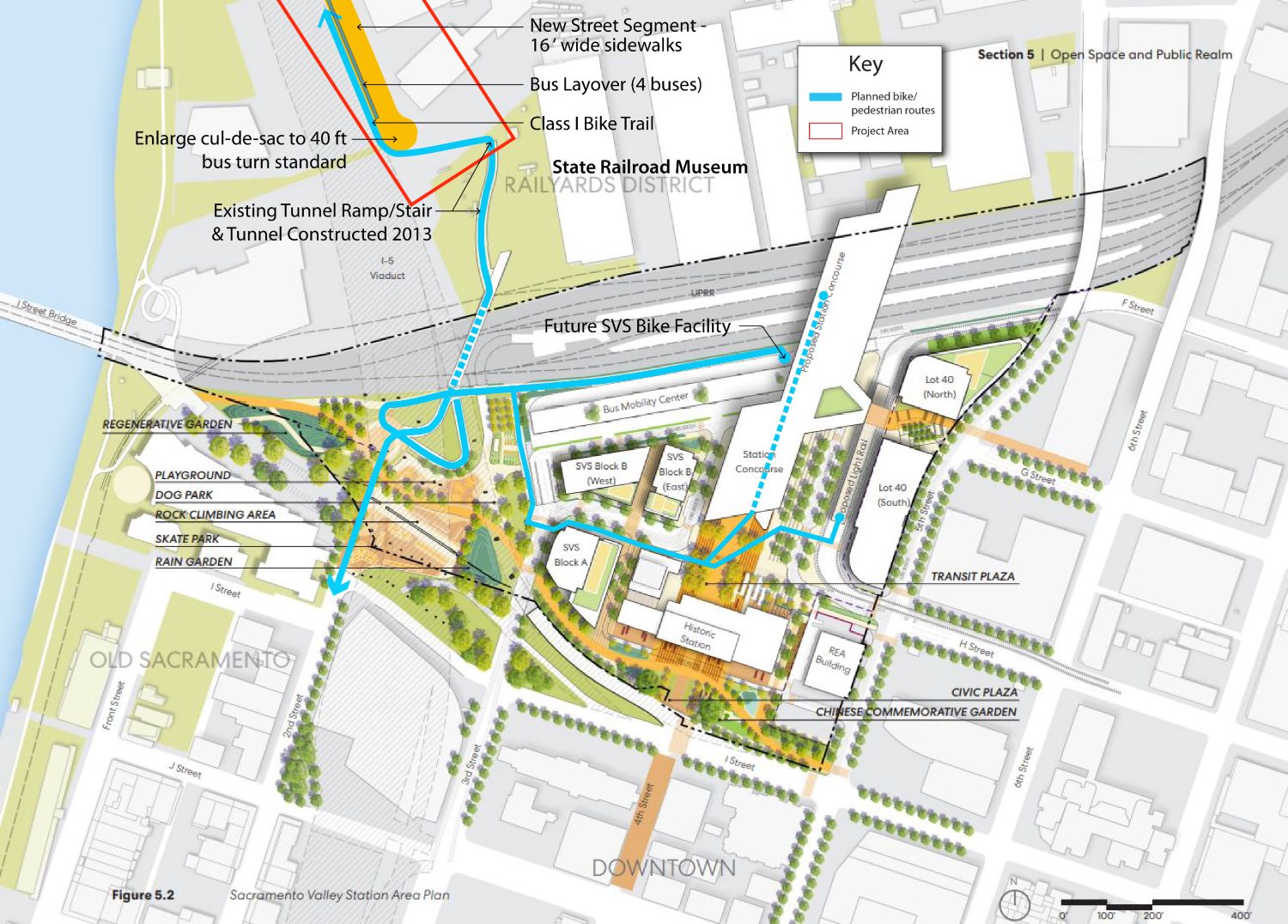
Western Connector map with Bike-Pedestrian Routes
Project Overview
Recent funding to the Railyards has allowed construction of primary street infrastructure which this project will fill in the missing link for bike and pedestrians traversing the railroad tracks along the west side of the Railyards development and historic shops.
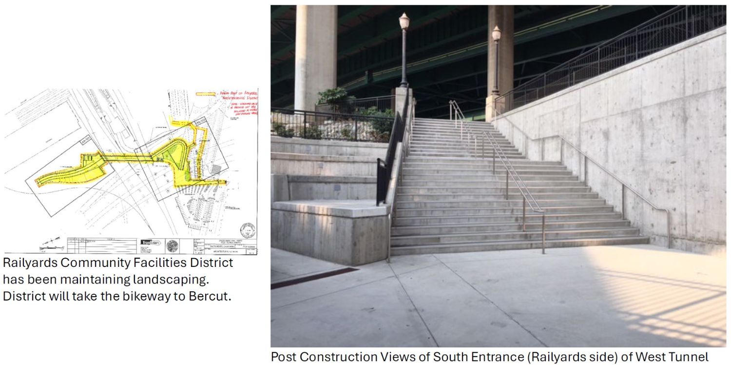
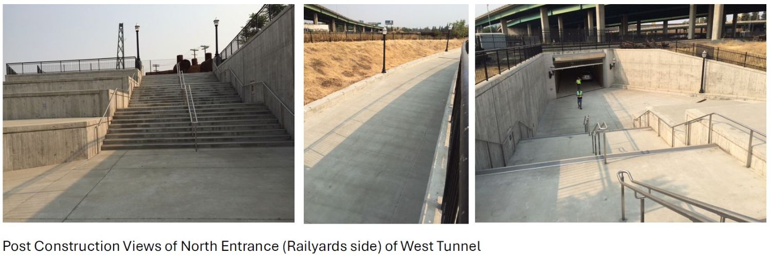
The project completes the remain 390 feet Bercut Drive that will also extend the Class I bike trail with a Class IV section to the entrance ramp of the existing West Tunnel that was constructed in 2012 but has yet to open pending this access to a public street. The tunnel is 20 feet wide with a wide staircase and separate ramp through a landscaped area that provides direct access to the Old Sacramento Waterfront and the walkway to the Sacramento Valley Station. The tunnel and approaches were completed in 2012 with the project to relocate the existing railroad mainline and the new passenger station infrastructure has been closed due to lack of connection to the public way on the north side of the privately held Railyards development area.
The project also provides for the opportunity for Sacramento Regional Transit bus layover facilities for routes serving the Railyards and the upcoming Kaiser medical facilities. The planned cul-de-sac terminus of Bercut Street will be enlarge to accommodate SacRT buses to turnaround and have curbside layover for their end of line for Railyards area services. The project will also provide a secure and dedicated restroom for the use of drivers at their end-of-line service break. The location of this layover will also make the boardings and alightings of large groups, such as school groups, easier when accessing the future California Railroad Museum facilities on the western edge of the historic Central Shops District.
Pedestrian sidewalks will be 8 ft in width and the existing Class 1 bike facility will extend around the cul-de-sac and connect to the existing Sacramento Valley Station Westside Tunnel with a Class IV parkway section for bike and pedestrian access, as well as small electric shuttles.
Future patrons of the California State Railroad Museum will also benefit from this connection, including the use of shuttle vehicles connecting the Museum assets on either side of the railroad mainline.
 open_in_full
South Side Westside Tunnel
Project Timeline
- July 2025 – Initiation of Engineering Design and Documents
- July 2026– Completion of Engineering Design and Documents
- Fall 2026 - Start of Construction
- Fall 2027 - Anticipated Construction Completion/Public Access
 open_in_full
North Side Westside Tunnel
Contact Us
For more information about the SVS Bus Stop 5th Street Extension project, please contact:
Greg Taylor, AIA, LEED AP, Supervising Architect, Project Manager
Email: gtaylor@cityofsacramento.org
Together, we can create a more efficient and accessible public transit system for everyone in Sacramento. Thank you for your patience and support as we work towards a better, more connected city!
ON THIS PAGE